Rural Municipality of Edenwold No. 158
The Rural Municipality of Edenwold No. 158 (2016 population: 4,490) is a rural municipality (RM) in the Canadian province of Saskatchewan within Census Division No. 6 and SARM Division No. 2. It is located in the southeast portion of the portion of the province, east of the City of Regina.
Edenwold No. 158 | |
|---|---|
| Rural Municipality of Edenwold No. 158 | |
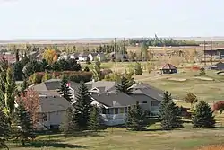 The community of Emerald Park | |
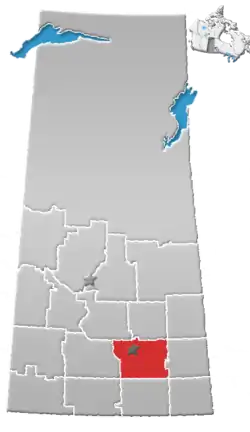
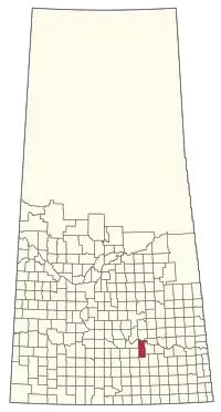 Location of the RM of Edenwold No. 158 in Saskatchewan | |
| Coordinates: 50.648°N 104.349°W[1] | |
| Country | Canada |
| Province | Saskatchewan |
| Census division | 6 |
| SARM division | 2 |
| Formed[2] | December 9, 1912 |
| Government | |
| • Reeve | Mitchell Huber |
| • Governing body | RM of Edenwold No. 158 Council |
| • Administrator | Kim McIvor |
| • Office location | Emerald Park |
| Area (2016)[4] | |
| • Land | 849.04 km2 (327.82 sq mi) |
| Population (2016)[4] | |
| • Total | 4,490 |
| • Density | 5.3/km2 (14/sq mi) |
| Time zone | CST |
| • Summer (DST) | CST |
| Area code(s) | 306 and 639 |
| Website | Official website |
History
The RM of Edenwold No. 158 incorporated as a rural municipality on December 9, 1912.[2]
Geography
In this area, the loggerhead shrike (Lanius ludovicianus excubitorides) and Sprague's pipit (Anthus spragueii) are both threatened species that are being monitored by conservationists.[5]
Communities and localities
The following urban municipalities are surrounded by the RM.
The following unincorporated communities are within the RM.
- Organized hamlets[6]
- Localities
- Coppersands
- Dreghorn
- Emerald Park
- Franksburg
- Frankslake
- Jameson
- Kathrintal Colony
- Milaty
- Poplar Park
- Richardson
- Seitzville
- Zehner
The RM also neighbours include six First Nations and six other RMs.
Climate
The RM of Edenwold experiences a dry humid continental climate (Köppen: Dfb) in the NRC Plant Hardiness Zone 3b.[7] The RM of Edenwold has warm summers and cold, dry winters, prone to extremes at all times of the year.
Demographics
In the 2016 Census of Population conducted by Statistics Canada, the RM of Edenwold No. 158 recorded a population of 4,490 living in 1,509 of its 1,546 total private dwellings, a 8.7% change from its 2011 population of 4,132. With a land area of 849.04 km2 (327.82 sq mi), it had a population density of 5.3/km2 (13.7/sq mi) in 2016.[4] The RM of Edenwold No. 158 is the second largest rural municipality in Saskatchewan and the 19th largest municipality in the province overall.[4]
In the 2011 Census of Population, the RM of Edenwold No. 158 recorded a population of 4,167, a 15.6% change from its 2006 population of 3,606. With a land area of 880.96 km2 (340.14 sq mi), it had a population density of 4.7/km2 (12.3/sq mi) in 2011.[10]
Government
The RM of Edenwold No. 158 is governed by an elected municipal council and an appointed administrator that meets on the second and fourth Tuesday of every month.[3] The reeve of the RM is Mitchell Huber while its administrator is Kim McIvor.[3] The RM's office is located in Emerald Park.[3]
References
- "Pre-packaged CSV files - CGN, Canada/Province/Territory (cgn_sk_csv_eng.zip)". Government of Canada. July 24, 2019. Retrieved May 23, 2020.
- "Rural Municipality Incorporations (Alphabetical)". Saskatchewan Ministry of Municipal Affairs. Archived from the original on April 21, 2011. Retrieved May 9, 2020.
- "Municipality Details: RM of Edenwold No. 158". Government of Saskatchewan. Retrieved May 21, 2020.
- "Population and dwelling counts, for Canada, provinces and territories, and census subdivisions (municipalities), 2016 and 2011 censuses – 100% data (Saskatchewan)". Statistics Canada. February 8, 2017. Retrieved May 1, 2020.
- "Saskatchewan Conservation Data Centre - Conservation Database". Saskatchewan Conservation Data Centre. 2007. Retrieved December 26, 2007.
- "2019-2020 Rural Revenue Sharing Organized Hamlet Grant". Government of Saskatchewan. Retrieved May 4, 2020.
- "Plant Hardiness Zone by Municipality". Natural Resources Canada. Government of Canada. Archived from the original on August 17, 2016. Retrieved July 31, 2016.
- "Saskatchewan Census Population" (PDF). Saskatchewan Bureau of Statistics. Archived from the original (PDF) on September 24, 2015. Retrieved May 9, 2020.
- "Saskatchewan Census Population". Saskatchewan Bureau of Statistics. Retrieved May 9, 2020.
- "Population and dwelling counts, for Canada, provinces and territories, and census subdivisions (municipalities), 2011 and 2006 censuses (Saskatchewan)". Statistics Canada. June 3, 2019. Retrieved May 1, 2020.
| Wikimedia Commons has media related to Edenwold No. 158. |
Places adjacent to Rural Municipality of Edenwold No. 158 | ||||||||||
|---|---|---|---|---|---|---|---|---|---|---|
| ||||||||||