Whitesboro, Oklahoma
Whitesboro is an unincorporated community and census-designated place (CDP) in Le Flore County, Oklahoma, United States. The population was 250 as of the 2010 census.[2]
Whitesboro, Oklahoma | |
|---|---|
 Whitesboro  Whitesboro | |
| Coordinates: 34°41′33″N 94°53′7″W | |
| Country | United States |
| State | Oklahoma |
| County | Le Flore |
| Area | |
| • Total | 3.31 sq mi (8.57 km2) |
| • Land | 3.31 sq mi (8.57 km2) |
| • Water | 0.0 sq mi (0.0 km2) |
| Elevation | 696 ft (212 m) |
| Population | |
| • Total | 250 |
| • Density | 76/sq mi (29.2/km2) |
| Time zone | UTC-6 (Central (CST)) |
| • Summer (DST) | UTC-5 (CDT) |
| ZIP code | 74577 |
| FIPS code | 40-80900 |
| GNIS feature ID | 1101736 |
A post office opened at Whitesboro, Indian Territory on April 14, 1902. The community took its name from Paul White, an early-day settler.[3]
At the time of its founding, Whitesboro was located in Wade County, a part of the Apukshunnubbee District of the Choctaw Nation.[4]
References
- "U.S. Gazetteer Files: 2019: Places: Oklahoma". U.S. Census Bureau Geography Division. Retrieved August 6, 2020.
- "Total Population: 2010 Census DEC Summary File 1 (P1), Whitesboro CDP, Oklahoma". data.census.gov. U.S. Census Bureau. Retrieved August 6, 2020.
- Shirk, George H. Oklahoma Place Names (Norman: University of Oklahoma, 1965), p. 222.
- Morris, John W. Historical Atlas of Oklahoma (Norman: University of Oklahoma, 1986), plate 38.
Municipalities and communities of Le Flore County, Oklahoma, United States | ||
|---|---|---|
| Cities | 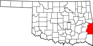 Le Flore County map | |
| Towns | ||
| CDPs | ||
| Other unincorporated communities | ||
| Indian reservation | ||
| Footnotes | ‡This populated place also has portions in another county or counties | |
| ||
This article is issued from Wikipedia. The text is licensed under Creative Commons - Attribution - Sharealike. Additional terms may apply for the media files.