Willow Glen, San Jose
Willow Glen is a neighborhood of San Jose, California, in Silicon Valley. Formerly its own municipality, the community was annexed by San Jose in 1936. Willow Glen is known for its historic downtown, dining and shopping, and is one of the most expensive neighborhoods to live in San Jose.[1]
Willow Glen | |
|---|---|
Neighborhood of San Jose | |
.jpg.webp) .jpg.webp) .jpg.webp) Clockwise: Garden Theatre, WG Stone Church, and Willow Glen Branch of the San José Public Library. | |
| |
| Coordinates: 37.30357°N 121.897345°W | |
| Country | United States |
| State | California |
| County | Santa Clara |
| City | San Jose |
| Elevation | 115 ft (35 m) |
History
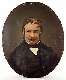
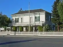
The neighborhood began in the mid-1800s as Rancho de los Coches and Rancho San Juan Bautista, Mexican land grants adjacent to the San Jose pueblo. Don Antonio Suñol, who owned Rancho de los Coches and built the Suñol House, is considered to be the founder of the community.[2] By the 1860s the small unincorporated community needed its first school, and Willow Glen Elementary School was founded in 1863 on land donated by Ira Cottle. Willow Glen continued as an unincorporated community until the 1920s, when the City of San Jose ordered the Southern Pacific Railroad to re-route the Southern Pacific Railroad trunk line which at that time was going down Fourth Street. The Southern Pacific then proposed to re-route down Lincoln Avenue. In order to forestall that attempt, Willow Glen was incorporated as a city in 1927.[3] The railroad was instead re-routed to its current route through a then-unincorporated area now known as North Willow Glen,[4] where its principal user is now Caltrain.
Being a city, however, required thinking about issues such as sewage. Willow Glen had no sewer system – individual homes had their own cesspools or septic systems. Because the area was marshy before being drained for Willow Glen,[5] the high water table resulted in raw sewage often spilling above-ground from flooded cesspools. Rather than build their own very expensive sewage treatment system, in 1936 Willow Glen's residents opted to be annexed to San Jose and be linked to San Jose's sewage system, the measure passing by a vote of 17 to 38.[6]
Lincoln Avenue was renamed from "Willow Glen Road" in 1865, shortly after the assassination of President Abraham Lincoln.[6]
Etymology and Development
"Willow Glen" was named for the marshy wet area between the Guadalupe River and Los Gatos Creek. The soggy land tended to produce vegetation like willows and cattails that are somewhat unique to the immediately surrounding area. As both waterways run south to north, the marsh was damper and less viable for planting and grazing year-round north toward the fork. What was historically called 'Willow Glen' would have actually originated at its northernmost point where the Los Gatos Creek runs into the Guadalupe River. This is the approximate site of the SAP Center in downtown San Jose today and would not be considered part of the Willow Glen neighborhood.
Over time, the historical community developed between the Guadalupe River and Los Gatos Creek, roughly two miles south of the point where they intersect, and beneath what is today Interstate 280. The modern community was largely founded by Frank Lewis and Isaac Bird (the namesake of "Bird Avenue"). Lewis noticed the potential of the marsh for raising crops and orchards, and in 1860 dug the channel between Willow Street and Curtner Avenue that carries the Guadalupe River to this day. That channel effectively drained the marsh and opened Willow Glen for farming. In turn, Bird started farming hops on the newly available farmland and found instant success producing some of the best hops and barley in the region. Bird's continued success brought fame to the region among local growers. By the late 1800s, Willow Glen was generally considered one of the most ideal spots in all of Santa Clara County for raising wheat, barley, hay, tobacco and hops. By 1880, plots of Willow Glen farmland were priced nearly 10 times higher than similar plots in the valley.
Geography
.jpg.webp)
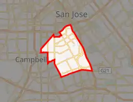
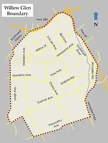
Willow Glen includes areas within zip code 95125, though not all of the zip code area can actually be considered to be part of the Willow Glen neighborhood, and there are areas within the 95126 zip code that many people would consider to be part of Willow Glen. The Willow Glen Neighborhood Association's by-laws reserve voting memberships to individuals and businesses within boundaries of the Association defined by the San Jose 2009 Greenprint - Willow Glen Planning Area Map, and within 1/2 mile of the Greenprint boundary.[7]
Interstate 280 is almost universally accepted as the community's northern border. The Guadalupe River was the original eastern border of Willow Glen during its time as a municipality. The Los Gatos Creek originally served as a natural western end for the community, until 1866, when extreme flooding of the creek caused it to naturally cut a new channel running far west around what was traditionally considered Willow Glen. The reshaped creek left behind a dry creek bed, known as the "Dry Creek," and opened up Willow Glen for greater southwest expansion.[8]
Architecture
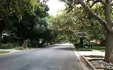
Willow Glen neighborhoods are almost exclusively composed of custom or semi-custom homes in a diverse range of architectural styles. Many architect-commissioned houses can be seen in the neighborhood, including Victorian, Neoclassical (Queen Anne Cottage and Neocolonial), Colonial Revival, Craftsman, Mission, Prairie, Spanish Eclectic, Eichler Homes, and Tudor.[9] In recent years many smaller houses have been replaced with larger houses.
Events
Dancin' on the Avenue
Dancin' on the Avenue was Willow Glen's annual street party that occurs on one day in the summer, along Lincoln Avenue between Willow Street and Minnesota Avenue. The event was organized by the Willow Glen Business Association. It ran from 1995 to 2018.[10]
Founders' Day
Founders' Day occurs in September although it has not been celebrated every year. The event celebrates the rich history, cultural heritage, and progressive present of the neighborhoods, homes, and community of Willow Glen. The highlight is a festive parade that proceeds down Lincoln Avenue. The origins of Founders' Day are not known. Archives of the Willow Glen Resident newspaper indicate it originates from the area's nine years of independence from San Jose between September 8, 1927 and September 4, 1936. Another view is that it celebrates the work of Antonio Suñol who built Laura Ville in 1847.
Christmas tree lights
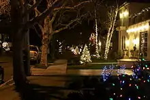
Willow Glen residents have a distinct Christmas tree decoration tradition. This tradition involves buying similar, very small, Christmas trees and placing them in the front yard ten feet from the sidewalk with multicolored lights. People and businesses in the neighborhood generally make significant decorations every year, both within the neighborhood and in the Lincoln Avenue business district, drawing visitors from all around the area.
The tradition of a Christmas tree on each residence's lawn was started in 1950 by Robert and Arlene Cimino. Trees were purchased in bulk from the Knights of Columbus and delivered to participating homes. The Ciminos moved from the area in 1956 and the tradition was continued by Frank Badagliacca, Jr. His wife, Dolores Badagliacca, came up with the idea of putting a single white light on the top of each tree. The tradition now stretches to over 200 streets in the greater San Jose area.[11]
Transportation
Although no railway stations exist within Willow Glen, the area is served well by VTA light rail's Blue Line[12] and Caltrain stations on or near its borders: Fruitdale, Race, Curtner, Tamien, Diridon, and Virginia.
Trails and bikeways
The two sections of the Los Gatos Creek Trail terminate in Willow Glen. The connection requires on-street travel through much of Willow Glen.
One section of the Guadalupe River Trail terminates near the far north east edge of Willow Glen but otherwise does not run through it.
The Highway 87 Bikeway runs along the eastern edge of Willow Glen but terminates at Willow Street at its most northern point.
The Three Creeks Trail runs diagonally through Willow Glen and passes close to downtown.
References
- "Willow Glen Business Association". Willow Glen Business Association. Retrieved July 24, 2020.
- [mercurynews.com/2013/09/04/parade-is-planned-for-founders-day-in-san-joses-willow-glen-community/ Mercury News - Parade is Planned for Founders Day in San Jose's Willow Glen Community]
- Barnes, Cecily (September 16, 1998). "Willow Glen residents think of their community, rather than their history, on Founders Day 1998". Willow Glen Resident. San Jose, California: Metro Publishing. Archived from the original on January 5, 2009.
- Erceg, Dan; et al. "A Short History of Willow Glen". North Willow Glen Neighborhood Association. Retrieved July 24, 2020.
- "The History of San Jose's Willow Glen District". Downtown Willow Glen. Willow Glen Business Association. Archived from the original on 2007-09-12. Retrieved 2007-04-18.
- Halberstadt, April Hope. "Willow Glen History". WillowGlen.com. Boulevards New Media. Archived from the original on March 25, 2016.
- "Planning Area". Willow Glen Neighborhood Association. Retrieved July 24, 2020.
- Halberstadt, April Hope (1997). The Willow Glen Neighborhood: Then and Now. San Jose Neighborhood Series. San Jose, California: Renasci. p. 14. ISBN 0-9641102-1-0.
- Ken Eklund (February 2003). "What Style is my House?". North Willow Glen Neighborhood Association. Retrieved August 10, 2013.
- Pizarro, Sal (June 8, 2018). "San Jose's big Dancin' on the Avenue bash calls it quits after two decades". The Mercury News. San Jose, California. Retrieved July 24, 2020.
- O'Hare, Meghan. "A Christmas Tale: Family that started the tree tradition". Archived from the original on December 31, 2012.,
- "Baypointe–Santa Theresa Line". Valley Transportation Authority. Retrieved July 24, 2020.
External links
| Wikimedia Commons has media related to Willow Glen, San Jose, California. |
