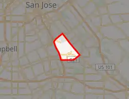
Communications Hill, San Jose
Communications Hill is a neighborhood located in the San Juan Bautista Hills of San Jose, California, in Silicon Valley.
Communications Hill | |
|---|---|
Neighborhood of San Jose | |
.jpg.webp) .jpg.webp) _(cropped).jpg.webp) .jpg.webp) | |
| |
| Coordinates: 37.2890°N 121.8551°W | |
| Country | United States |
| State | California |
| County | Santa Clara |
| City | San Jose |
| Elevation | 438.87 ft (133.77[1] m) |
| Population (2016)[2] | |
| • Total | 11,267 |
History
Before the Spanish entrada, the Tamyen people mined the area for chert, which was typically used for debitage and arrow points.
On November 29, 1777, Juan Bautista de Anza selected the area to become the southernmost region in the first land tract of the San Jose pueblo (the first pueblo-town in California not associated with a mission or a military post). Although similarly named, the area was not part of the neighboring Rancho San Juan Bautista Mexican land grant.[3]
Located in the northern area of Communications Hill,[4] Oak Hill Memorial Park, the oldest secular cemetery operating in California, performed its first recorded burial in 1847.
Cinnabar is believed to have been discovered in the San Juan Bautista Hills in 1847 by a member of the Chaboya family.[5] Soon afterwards, the Hillsdale Mine was established. However, operations were unsuccessful and the mine ceased operations in 1907.
Tyler Beach purchased the Dairy Hill area in the late 1860s and named it Beach Hill Farm, which was used to supply the former St. James Hotel.
On March 2, 1886, Southern Pacific incorporated the San Jose & Almaden Railroad (consolidated with the Southern Pacific on May 14, 1888) to build the Lick Branch from Hillsdale (now Capitol Station) 7.7 miles to Almaden. The branch was opened on November 16, 1866 and ran for several years.[6] However, the line was shortened due to an abandonment in 1937 (probably due to the New Almaden mine shutting down after the Great Depression). The remainder of the Lick Branch was formally abandoned in January of 1981.[7]
Between 1887 and 1890, the San Jose Vineyard operated in the area.[8]
.jpg.webp)
In the late 1800s, José S. Azevedo (of the Azevedo-Machado-Vieira family, a prominent Portuguese-American family of San Jose) emigrated from São Jorge Island in the Azores. He purchased 96 acres of land in the area in 1896 and created a dairy farm known as the American Dairy Company.[9][10]
In 1916 (after José S. Azevedo's passing in 1915), Manuel Azevedo and Manuel Lewis took over the dairy farm.[11] Manuel Azevedo’s nephew, Manuel Bettencourt managed the creamery after Manuel Azevedo passed away. After Manuel Bettencourt passed away, control of the dairy went to Bettencourt’s nephew, Anthony Bettencourt. In the 1970s, control of the ranch passed to Anthony Bettencourt’s son, Robert J. Bettencourt who continues own land in the area through a family trust known as Mta Land Corporation.[12]
The Azevedo Quarry was actively mined by Raisch Products from 1971 to 2006 (reclamation activity continued until 2009).[13] An aggregate recycling facility remains on the land, but it is also expected to shutdown in 2023 and be redeveloped into an office park when the county use permit expires.[14]
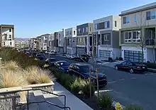
Starting in 1984, the Government of San Jose began preparing Communications Hill, then largely barren, for development into a mixed-use, high density, urban neighborhood. This was formalized with the creation of the Communications Hill Specific Plan in 1992.[15] Mta Land Corporation, a family trust managed by the Bettencourt family, began the process of residential development in 2002.[16]
Annexation of parcels to the city of San Jose has occurred as recently as December 9, 2014.[17]
The area is currently undergoing significant construction, which has been divided into four phases.[18]
A "village center" is planned, which will include shops and restaurants positioned to have a view of the Downtown San Jose skyline.[19]
Geography
The Communications Hill neighborhood is located east of California State Route 87, west of Monterey Road, north of Capitol Expressway and south of Curtner Avenue.[20][21][22]
Parks and trails
.jpg.webp)
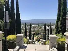
The neighborhood has multiple scenic overlooks of the Santa Cruz Mountains, Diablo Range, and the surrounding Santa Clara Valley.[23]
Communications Hill is home to the following parks and trails:[24]
- Vieira Park
- Communications Hill Trail
- Elaine Richardson Park
- Communications Hill Grand Staircase
- Hillcrest Open Space[25][26]
- Hillsdale Fitness Park
- Kurte Park
- Margaret Kell Park
- Rancho San Juan Bautista Park
- Waterford Park
- William Lewis Manly Park
Transportation
Nearby public transportation options include:
- Capitol station (VTA) for light rail.
- Capitol station (Caltrain) for commuter rail.
- Curtner station for light rail.
A pedestrian bridge and trail are planned to allow easier access to the Capitol Caltrain station.[27]
Public services
Communications Hill is home to Engine House 33 of the San José Fire Department.
References
| Wikimedia Commons has media related to Communications Hill, San Jose, California. |
- https://www.usgs.gov/core-science-systems/ngp/3dep
- https://www.sccgov.org/sites/phd/hi/hd/Documents/City%20Profiles/San%20Jose%20Neighborhoods/CommHill_neighprofilesPDF15017.pdf
- 1876 map showing San Juan Bautista Hills in the San Jose Pueblo Tract No. 1
- Map of Communications Hill showing the location of Oak Hill Memorial Park
- Bradley, W.W. (1918). Quicksilver resources of California, with a section on metallurgy and ore dressing: California Mining Bureau. 78.
- The Western Railroader - Page Three, NEW ALMADEN BRANCHES, South Pacific Coast Railway, Southern Pacific Railroad
- Abandoned Rails of San Jose, California - Lick Branch
- Communications Hill Archaeological Evaluation
- UC Berkeley Bancroft Library Regional Oral History Office - Batista Vieira: An Oral History
- Valley Transportation Authority - VTA BART Silicon Valley - Phase II Extension Project Supplemental Report
- Dairy Hill - People - Manuel Azevedo
- The Azevedos and the American Dairy Company
- [http://sccgov.iqm2.com/Citizens/Detail_LegiFile.aspx?ID=70777 Report 70777 - Accept report from Department of Planning and Development relating to status of the County's Surface Mining and Reclamation Act (SMARA) Program]
- Communications Hill Air Quality Assessment 2014
- City of San Jose: Development - Communications Hill
- High-density housing development set
- Annexation - Communications Hill No. 1
- Communications Hill Permit Applications
- Planned Development Permit Amendment Phase 2 and Phase 3 Meeting: June 15, 2017
- Census Neighborhood Profile
- Communications Hill - City of San Jose
- OpenStreetMap Communications Hill Locality
- City of San Jose Neighborhood Boundaries Map
- City of San Jose - Parks & Recreation: Communications Hill
- Hillcrest Open Space OSM Relation
- San Jose Communications Hill Parkland Agreement
- San Jose 2040 Plan Proposed Amendments