Wilson Island (Ritchie's Archipelago)
Wilson Island is an island of the Andaman Islands. It belongs to the South Andaman administrative district, part of the Indian union territory of Andaman and Nicobar Islands.[6] the island lies 57 km (35 mi) northeast from Port Blair.
| Nickname: Sir Archdale Wilson Island | |
|---|---|
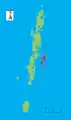
 Wilson Island Location of Wilson Island  Wilson Island Wilson Island (India) | |
| Geography | |
| Location | Bay of Bengal |
| Coordinates | 12.13°N 92.98°E |
| Archipelago | Andaman Islands |
| Adjacent bodies of water | Indian Ocean |
| Area | 14.3 km2 (5.5 sq mi)[1] |
| Length | 4.1 km (2.55 mi) |
| Width | 4.3 km (2.67 mi) |
| Coastline | 16.2 km (10.07 mi) |
| Highest elevation | 216 m (709 ft)[2] |
| Highest point | Round Hill |
| Administration | |
| District | South Andaman |
| Island group | Andaman Islands |
| Island sub-group | Ritchie's Archipelago |
| Tehsil | Port Blair Tehsil |
| Demographics | |
| Population | 0 (2011) |
| Additional information | |
| Time zone |
|
| PIN | 744202[3] |
| Telephone code | 031927 [4] |
| ISO code | IN-AN-00[5] |
| Official website | www |
Etymology
Wilson is named after Brigadier Commander Sir Archdale Wilson.
History
The establishment of a lighted beacon on Wilson Island was over due. It was during 1993-94 that the G.I. trestle was erected on the North-West shore of the island and the modern solar powered equipment from ‘Tide land’ of USA was installed over the trestle tower. The lighthouse was commissioned on 23 March 1994.[7] the lighthouse is accessible only by boat.
Geography
The island belongs to the Ritchie's Archipelago and is located between Nicholson Island and John Lawrence Island. a narrow channel (400 m (1,312 ft)) separates it from Sir William Peel Island to the south.
Administration
Politically, Wilson Island is part of Port Blair Taluk.[8]
Demographics
The island is uninhabited.
Image gallery
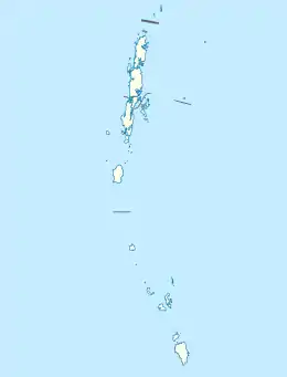
 Outline map of the Andaman Islands, with Ritchie's Archipelago highlighted (in red).
References
- "Islandwise Area and Population - 2011 Census" (PDF). Government of Andaman.
- Sailing Directions (Enroute), Pub. 173: India and the Bay of Bengal (PDF). Sailing Directions. United States National Geospatial-Intelligence Agency. 2017. p. 283.
- "A&N Islands - Pincodes". 22 September 2016. Archived from the original on 23 March 2014. Retrieved 22 September 2016.
- "STD Codes of Andaman and Nicobar". allcodesindia.in. Retrieved 23 September 2016.
- Registration Plate Numbers added to ISO Code
- "Village Code Directory: Andaman & Nicobar Islands" (PDF). Census of India. Retrieved 16 January 2011.
- "Government of India, Directorate General of Lighthouses and Lightships". www.dgll.nic.in. Retrieved 18 October 2016.
- "DEMOGRAPHIC – A&N ISLANDS" (PDF). andssw1.and.nic.in. Retrieved 23 September 2016.
 Ritchie's Archipelago travel guide from Wikivoyage