Wiri
Wiri is a mostly industrial-commercial focused suburb in Auckland, New Zealand. It was formerly part of Manukau City until the merger of all of Auckland's councils into the 'super city' in 2010.
Wiri | |
|---|---|
Suburb | |
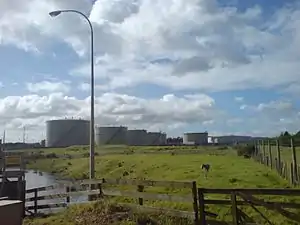 A petroleum-product storage depot at the western edge of Wiri | |

| |
| Country | New Zealand |
| Local authority | Auckland Council |
| Electoral ward | Manurewa-Papakura Ward |
| Local board | Manurewa Local Board |
| Population (2018) | |
| • Total | 5,355 |
| Train station(s) | Wiri Train Station (closed) |
| Papatoetoe, Mangere | Papatoetoe | Manukau Central |
| (Manukau Harbour) |
|
Goodwood Heights |
| (Manukau Harbour) | Clendon Park | Homai |
As of 2009, Ports of Auckland is building an inland port / rail siding in Wiri, to connect road freight to the port facilities on the Waitemata Harbour further north. The new facility will allow Ports of Auckland to reduce the number of trucks that have to travel through the Auckland Central area by up to 100,000 trips per year.[1]
Auckland Region Women's Corrections Facility (ARWCF) is located in Wiri. ARWCF is the first purpose-built women's prison in New Zealand to accommodate a growing number of female prisoners and services in the upper North Island. The facility can accommodate 286 prisoners and employs 167 staff.[2]
The adjacent Auckland South Corrections Facility is a high security men's prison which opened in 2015.[3] It is operated by Serco New Zealand under a Public Private Partnership with the Department of Corrections.[3] at 20 Hautu Drive, Wiri.[4]
As part of the Auckland railway electrification project, the $100 million EMU maintenance and stabling depot was built on 4.4 hectares of the old Winstone Quarry in Wiri, located next to the South-Western Motorway and bordered by Roscommon and Wiri Station Roads. It was officially opened by the Mayor of Auckland on 5 July 2013.[5]
The Matukutūruru (Wiri Mountain) and Matukutūreia (McLaughlins Mountain) volcanoes are in Wiri.
Demographics
| Year | Pop. | ±% p.a. |
|---|---|---|
| 2006 | 3,867 | — |
| 2013 | 3,921 | +0.20% |
| 2018 | 5,355 | +6.43% |
| Source: [6] | ||
Wiri, comprising the statistical areas of Wiri West and Wiri East, had a population of 5,355 at the 2018 New Zealand census, an increase of 1,434 people (36.6%) since the 2013 census, and an increase of 1,488 people (38.5%) since the 2006 census. There were 999 households. There were 2,814 males and 2,544 females, giving a sex ratio of 1.11 males per female, with 1,311 people (24.5%) aged under 15 years, 1,410 (26.3%) aged 15 to 29, 2,145 (40.1%) aged 30 to 64, and 492 (9.2%) aged 65 or older.
Ethnicities were 20.4% European/Pākehā, 31.2% Māori, 47.2% Pacific peoples, 18.0% Asian, and 2.0% other ethnicities (totals add to more than 100% since people could identify with multiple ethnicities).
The proportion of people born overseas was 33.8%, compared with 27.1% nationally.
Although some people objected to giving their religion, 24.9% had no religion, 51.8% were Christian, 4.7% were Hindu, 3.2% were Muslim, 1.3% were Buddhist and 7.6% had other religions.
Of those at least 15 years old, 363 (9.0%) people had a bachelor or higher degree, and 906 (22.4%) people had no formal qualifications. The employment status of those at least 15 was that 1,440 (35.6%) people were employed full-time, 387 (9.6%) were part-time, and 360 (8.9%) were unemployed.
Wiri West is mostly industrial and commercial, while Wiri East is mostly residential.[6]
Education
Wiri Central School is a full primary school (years 1–8) with a roll of 353 as of March 2020.[7][8]
Destiny School is a private evangelical Christian composite school (years 1–13) with a roll of 119 as of March 2020.[7][9]
Both schools are coeducational.
References
- Major milestone achieved for Wiri Inland Port rail link (Ports of Auckland press release, via infonews.co.nz, 12 November 2009. Accessed 2009-10-14.)
- http://2cu.co.nz/auckland/listings/101141-auckland-region-women-s-corrections-facility--arwcf-
- Vance, Anrea (20 February 2019). "$1.1m bonus for private prison company Serco, for keeping people out of jail". Retrieved 12 March 2019.
- http://www.stuff.co.nz/auckland/local-news/manukau-courier/8693586/Graduate-system-to-feature-in-prison
- http://www.aucklandtransport.govt.nz/about-us/News/LatestNews/Pages/Maintenance-and-stabling-facility-opens-for-Auckland%27s-new-trains.aspx
- "Statistical area 1 dataset for 2018 Census". Statistics New Zealand. March 2020. Wiri West (157600) and Wiri East (158400). 2018 Census place summary: Wiri West 2018 Census place summary: Wiri East
- "New Zealand Schools Directory". New Zealand Ministry of Education. Retrieved 26 April 2020.
- Education Counts: Wiri Central School
- Education Counts: Destiny School
External links
- Photographs of Wiri held in Auckland Libraries' heritage collections.
| Wikimedia Commons has media related to Wiri. |
