Wisconsin Highway 54
State Trunk Highway 54 (often called Highway 54, STH-54 or WIS 54) is a Wisconsin state highway running east–west across central Wisconsin. It is 243.12 miles (391.26 km) in length.
| ||||
|---|---|---|---|---|
| Wisconsin Firefighters and Emergency Medical Technicians Highway | ||||
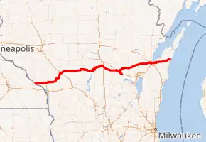
WIS-54 highlighted in red | ||||
| Route information | ||||
| Maintained by WisDOT | ||||
| Length | 243.12 mi[1][2] (391.26 km) | |||
| Major junctions | ||||
| West end | ||||
| East end | ||||
| Location | ||||
| Counties | Buffalo, Trempealeau, Jackson, Wood, Portage, Waupaca, Outagamie, Brown, Kewaunee | |||
| Highway system | ||||
| ||||

Route description
Minnesota state line to Plover
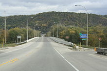
WIS 54 begins at the western terminus. It crosses through the Minnesota state line at Winona, Minnesota via the North Channel Bridge. At this bridge, MN 43 ends there. After crossing the bridge, it soon turns east via WIS 35/Great River Road. In Centerville, WIS 35, as well as the Great River Road, turn southward; leaves the concurrency. At the same junction, WIS 93 joins the concurrency eastward. Further east, they then start to run concurrently with US 53 in Galesville. However, as they travel eastward, WIS 54 turns northeast, leaving the concurrency.
At Butman Corners, WIS 54 then turns east again. After leaving Butman Corners, it closely parallels the Black River just south of the route. Then, it meanders eastward towards Melrose. In Melrose, it meets WIS 71/WIS 108 where they end. Continuing north, it continues to parallel the river. In Black River Falls, it briefly runs concurrently with US 12 and WIS 27 on the bridge. After crossing the bridge, WIS 54 becomes a four-lane divided highway. At that point, it no longer follows the river.
Going east, it then meets I-94 at a diamond interchange. After leaving Vaudreuil out northeast, WIS 54 then downgrades into a two-lane undivided highway. Then, it continues going eastward. At Dexterville, WIS 54 briefly traveled southward via WIS 80. Continuing eastward, WIS 54 then runs concurrently with WIS 73 from Port Edward to Wisconsin Rapids. At the start of the concurrency, it, as well as WIS 73, starts to follows the Wisconsin River. In Wisconsin Rapids, WIS 54 turns east, following WIS 13. This concurrency with WIS 13 runs from the west end of the Wisconsin River bridge to 8th Street. WIS 54 then turns north near the city limit. At Robinson Park, WIS 54 curves east. Although it still closely parallels the river, it is now on the east/south side of the river. At Plover, WIS 54 then turns southeast via Bus. US 51. At that point, it no longer follows the river again.[2]
Plover to Algoma
Continuing southeast, both routes continue to run concurrently until they meet I-39/US 51 interchange. At that point, Bus. US 51 ends there. WIS 54 continues to travel southeast. However, at one point, it then turns east towards Waupaca. At Waupaca, WIS 54 runs concurrently with US 10 as well as WIS 49. At the next interchange out east, WIS 22 joins the concurrency. Just west of the Waupaca Municipal Airport, WIS 54 and WIS 22 leaves the concurrency. Continuing northeast, they then run concurrently with WIS 110 for 2.3 miles (3.7 km). After WIS 110, as well as WIS 22, leaves the concurrency, WIS 54 then travels east. Near the Newton Blackmour State Trail in New London, US 45 meets WIS 54 at a parclo. At that point, the route parallels the state trail.
In Shiocton, WIS 76 briefly runs concurrently with WIS 54. East of the concurrency, it intersects WIS 187. In Black Creek, it intersects WIS 47. South of Seymour, WIS 55 travels eastward via WIS 54 for 2 miles (3.2 km). After WIS 55 turns south, WIS 54 enters the Oneida Reservation. It then turns northeast after intersecting with WIS 172.
After entering Green Bay, WIS 54 becomes a four-lane divided highway. After that, it turns eastward. At the dumbbell interchange, WIS 54 meets I-41/US 41 while WIS 32 runs concurrently with WIS 54. As they get close to downtown, WIS 32 leaves southward while WIS 54 becomes a limited-access road. After crossing a bascule bridge above the Fox River, WIS 54 leaves Mason Street for Monroe Street. At that point, WIS 54 runs concurrently with WIS 57.
In downtown, WIS 29 then briefly joins the concurrency between Walnut Street and Main Street. At Main Street, US 141 intersects with three routes. This is where WIS 29 turns southeast. After crossing that intersection, they then turn southeast and then east. They then meet I-43 at a parclo. After meeting with I-43, the road becomes a freeway. In the middle of it, WIS 54 leaves the freeway. It continues to travel eastward through the Door Peninsula until reaching WIS 42 in downtown Algoma. At that point, WIS 54 ends there.[2]
History
Initially, WIS 54 ran from Green Bay to WIS 17 (now part of WIS 42) in Algona.[3] In 1920, WIS 54 extended westward to WIS 22 in Royalton.[4] In 1924, WIS 54 extended westward to the Mississippi River. This route largely followed its present-day routing. As a result of the extension, it replaced parts of WIS 66 from Wisconsin Rapids to Plover and WIS 52 from Decora Prairie to Black River Falls.[5] By 1931, a portion of WIS 54 between Shiocton and Black Creek was straightened.[6] By 1932, WIS 54 took a different approach to connect to Green Bay from the west. This time, it took Mason Street instead of WIS 29/WIS 32.[7]
Major intersections
| County | Location | mi[2] | km | Exit | Destinations | Notes |
|---|---|---|---|---|---|---|
| Mississippi River | 0.0 | 0.0 | Continuation into Minnesota | |||
| North Channel Bridge | ||||||
| Buffalo | Town of Buffalo | Western end of WIS 35 concurrency | ||||
| Trempealeau | Town of Trempealeau | Eastern end of WIS 35 concurrency; western end of WIS 93 concurrency | ||||
| Galesville | Western end of US 53 concurrency | |||||
| Town of Gale | Eastern end of US 53/WIS 93 concurrency | |||||
| Jackson | Melrose | Western terminus of WIS 71; northern terminus of WIS 108 | ||||
| Black River Falls | Western end of US 12/WIS 27 concurrency | |||||
| Eastern end of US 12/WIS 27 concurrency | ||||||
| Exit 116 along I-94 | ||||||
| Wood | Dexter | Western end of WIS 80 concurrency | ||||
| Eastern end of WIS 80 concurrency | ||||||
| Port Edwards | Western end of WIS 73 concurrency | |||||
| Wisconsin Rapids | Eastern end of WIS 73 concurrency; western end of WIS 13 concurrency | |||||
| Eastern end of WIS 13 concurrency | ||||||
| Portage | Plover | Western end of Bus. US 51 concurrency | ||||
| Town of Plover | Southern terminus of Bus. US 51 | |||||
| Waupaca | Waupaca | Western end of US 10/WIS 49 concurrency | ||||
| 252 | Western end of WIS 22 concurrency | |||||
| Town of Waupaca | 253 | Churchill Street | ||||
| Waupaca | Eastern end of US 10/WIS 49 concurrency | |||||
| Royalton | Western end of WIS 110 concurrency | |||||
| Eastern end of WIS 22/WIS 110 concurrency | ||||||
| Outagamie | New London | Interchange | ||||
| Shiocton | Western end of WIS 76 concurrency | |||||
| Eastern end of WIS 76 concurrency | ||||||
| Southern terminus of WIS 187 | ||||||
| Black Creek | ||||||
| Seymour | Western end of WIS 55 concurrency | |||||
| Town of Oneida | Eastern end of WIS 55 concurrency | |||||
| Brown | Hobart | Roundabout; western terminus of WIS 172 | ||||
| Green Bay | Western end of WIS 32 concurrency | |||||
| — | Eastern end of WIS 32 concurrency; western end of freeway | |||||
| — | Broadway | Westbound exit and eastbound entrance | ||||
| — | Madison Street – Downtown | Eastbound exit and westbound entrance | ||||
| — | Western end of WIS 57 concurrency | |||||
| Western end of WIS 29 concurrency | ||||||
| Eastern end of WIS 29 concurrency | ||||||
| — | Western end of freeway | |||||
| — | University Avenue; Nicolet Drive | |||||
| — | ||||||
| — | Western end of WIS 57 concurrency; WIS 57 freeway continues north | |||||
| Kewaunee | Algoma | Eastern terminus | ||||
1.000 mi = 1.609 km; 1.000 km = 0.621 mi
| ||||||
See also
 U.S. Roads portal
References
- Bessert's, Christopher J. "Highways 50 through 59". Wisconsin Highways.
- Google (December 20, 2020). "Overview map of WIS 54" (Map). Google Maps. Google. Retrieved December 20, 2020.
- Wisconsin Highway Commission (1918). Official Map of the State Trunk Highway System of Wisconsin (Map). [c. 1:1,010,000]. Madison: Wisconsin Highway Commission. OCLC 38871736, 69119995. Retrieved December 22, 2020 – via American Geographical Society Library Digital Map Collection.
- Wisconsin Highway Commission (1920). Official Map of the State Trunk Highway System of Wisconsin (Map). Scale not given. Madison: Wisconsin Highway Commission. OCLC 5673515.
- Wisconsin Highway Commission (1924). Official Highway Map of Wisconsin: 'The Playground of the Middle West' (Map). c. 1:950,400. Madison: Wisconsin Highway Commission. OCLC 560719947. Retrieved December 22, 2020 – via American Geographical Society Library Digital Map Collection.
- Wisconsin Highway Commission (1931). Official Highway Map of Wisconsin (Map). 1:887,040. Madison: Wisconsin Highway Commission. Retrieved December 22, 2020 – via Wisconsin Historical Society.
- Wisconsin Highway Commission (1932). Official Highway Map of Wisconsin (Map). 1:887,040. Madison: Wisconsin Highway Commission. Retrieved December 22, 2020 – via American Geographical Society Library Digital Map Collection.
External links
 Media related to Wisconsin Highway 54 at Wikimedia Commons