Wisconsin Highway 47
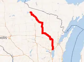
State Trunk Highway 47 (often called Highway 47, STH-47 or WIS 47) is a 188.01-mile (302.57 km) state highway in the northeastern and northern parts of the US state of Wisconsin that runs in a diagonal northwest–southeast from Menasha to Manitowish.
| ||||
|---|---|---|---|---|
WIS 47 highlighted in red | ||||
| Route information | ||||
| Maintained by WisDOT | ||||
| Length | 188.01 mi[1] (302.57 km) | |||
| Major junctions | ||||
| South end | ||||
| North end | ||||
| Location | ||||
| Counties | Winnebago, Outagamie, Shawano, Menominee, Langlade, Oneida, Vilas, Iron | |||
| Highway system | ||||
| ||||

Route description

The southern terminus of WIS 47 is at WIS 114 at the corner of Third and De Pere streets in Menasha.
Of the 188-mile (303 km) route, about 76 miles (122 km) are cosigned with other highways. From south to north, WIS 47 is aligned with WIS 29 from south of Bonduel to south of Shawano, WIS 55 from south of Bonduel to Keshena. After a solo segment, WIS 47 follows US Highway 45 (US 45) from south of Antigo to Monico and US 8 from Monico to Rhinelander.[1]
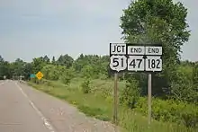
The northern terminus of WIS 47 is a combined terminus with WIS 182 at US 51 in Manitowish.
History
At its inception, WIS 47 ran from WIS 15 in Appleton to WIS 29 in Bonduel. In 1919, the highway was expanded north to Antigo, where it ended at US 45. In 1925, it was extended along US 45 to Woodruff. In 1937, it was extended along the old US 41 to Menasha. In 1952, it was extended north to Manitowish. In 1997, freeway was added with the WIS 29/WIS 55 bypass near Bonduel.[1]
Major intersections
| County | Location | mi | km | Destinations | Notes | |
|---|---|---|---|---|---|---|
| Winnebago | Menasha | 0.0 | 0.0 | |||
| 2.3 | 3.7 | |||||
| Outagamie | Appleton | 4.4 | 7.1 | |||
| 5.2 | 8.4 | |||||
| 7.0 | 11.3 | |||||
| Black Creek | 20.1 | 32.3 | ||||
| Shawano | Pulaski | 28.9 | 46.5 | Southern end of WIS 156 concurrency | ||
| 29.4 | 47.3 | Northern end of WIS 156 concurrency | ||||
| Shawano | 37.4 | 60.2 | Eastern end of WIS 29 concurrency; southern end of WIS 55 concurrency | |||
| 44.1 | 71.0 | Western end of WIS 29 concurrency | ||||
| 46.0 | 74.0 | Eastern end of WIS 22 concurrency | ||||
| 48.0 | 77.2 | Western end of WIS 22 concurrency | ||||
| Menominee | Keshena | 56.4 | 90.8 | Northern end of WIS 55 concurrency | ||
| Langlade | Town of Rolling | 86.3 | 138.9 | Southern end of US 45 concurrency; western end of WIS 52 concurrency | ||
| Antigo | 93.7 | 150.8 | Eastern end of WIS 55 concurrency | |||
| Oneida | Monico | 124.0 | 199.6 | Eastern end of US 8 concurrency; northern end of US 45 concurrency | ||
| Rhinelander | 135.1 | 217.4 | Northern end of WIS 17 concurrency | |||
| 137.8 | 221.8 | Southern end of WIS 17 concurrency | ||||
| 138.2 | 222.4 | Western end of US 8 concurrency | ||||
| Woodruff | 161.5 | 259.9 | ||||
| Iron | Town of Sherman | 184.2 | 296.4 | Western end of WIS 182 concurrency | ||
| Manitowish | 188.01 | 302.57 | Eastern end of WIS 182 concurrency | |||
1.000 mi = 1.609 km; 1.000 km = 0.621 mi
| ||||||
See also
 U.S. Roads portal
References
- Bessert, Chris. "Wisconsin Highways: Highways 40-49 (Highway 47)". Wisconsin Highways. Retrieved March 20, 2007.
External links
 Media related to Wisconsin Highway 47 at Wikimedia Commons