Wolfartsweier
Wolfartsweier (population approx. 3,500) is a village near Karlsruhe, Baden-Württemberg, Germany. It was first mentioned in 1261 AD under the name of "Wolvoldeswilere". The local church was first mentioned in 1329. A small creek, called Wettersbach, runs through the village, but in an underground canal for most of its way. Wolfartsweier has a town hall, a Protestant and a catholic church and community centres, and a public outdoor swimming pool.
Wolfartsweier | |
|---|---|
Borough of Karlsruhe | |
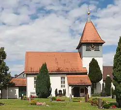 Protestant church of Wolfartsweier | |
 Coat of arms | |
Location of Wolfartsweier in Karlsruhe 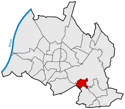 | |
 Wolfartsweier  Wolfartsweier | |
| Coordinates: 48°58′28″N 8°27′13″E | |
| Country | Germany |
| State | Baden-Württemberg |
| Admin. region | Karlsruhe |
| District | Urban district |
| City | Karlsruhe |
| Area | |
| • Total | 2.0058 km2 (0.7744 sq mi) |
| Population (2017-03-17) | |
| • Total | 3,154 |
| • Density | 1,600/km2 (4,100/sq mi) |
| Time zone | UTC+01:00 (CET) |
| • Summer (DST) | UTC+02:00 (CEST) |
| Postal codes | 76228 |
| Dialling codes | 0721 |

Katzenkindergarten
In 2002, a new creche, the "Katzenkindergarten", was built in the shape of a lying cat. (Architect Ayla Yöndel / Idea and concept Tomi Ungerer)
Wolfartsweier lost its independence in 1973 when it became part of Karlsruhe.
This article is issued from Wikipedia. The text is licensed under Creative Commons - Attribution - Sharealike. Additional terms may apply for the media files.
