Wonnie, Kentucky
Wonnie is an unincorporated community in Magoffin County, Kentucky, United States. It lies along U.S. Route 460 and Kentucky Route 1081 northwest of the city of Salyersville, the county seat of Magoffin County.[1] Its elevation is 814 feet (248 m).[2]
Wonnie | |
|---|---|
 Wonnie Location within the state of Kentucky  Wonnie Wonnie (the United States) | |
| Coordinates: 37°48′33″N 83°9′15″W | |
| Country | United States |
| State | Kentucky |
| County | Magoffin |
| Elevation | 814 ft (248 m) |
| Time zone | UTC-5 (Eastern (EST)) |
| • Summer (DST) | UTC-4 (EDT) |
| ZIP codes | 41475 |
| GNIS feature ID | 509400 |
References
- Rand McNally. The Road Atlas '06. Chicago: Rand McNally, 2006, p. 43.
- U.S. Geological Survey Geographic Names Information System: Wonnie, Kentucky, Geographic Names Information System, 1979-09-20. Accessed 2008-01-03.
Municipalities and communities of Magoffin County, Kentucky, United States | ||
|---|---|---|
| City | 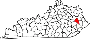 Location of Magoffin County, Kentucky | |
| Unincorporated communities | ||
| ||
This article is issued from Wikipedia. The text is licensed under Creative Commons - Attribution - Sharealike. Additional terms may apply for the media files.