Woodberry, New South Wales
Woodberry is one of the easternmost suburbs of the City of Maitland in the Hunter Region of New South Wales, Australia.[2][5] At the 2011 census, Woodberry's population was 3,155.[1] Most of the population lives in residential subdivisions while almost 84% of the suburbs land is rural in nature.[5] Rental accommodation is occupied by 33.33% of the residents.[6]
| Woodberry Maitland, New South Wales | |||||||||||||||
|---|---|---|---|---|---|---|---|---|---|---|---|---|---|---|---|
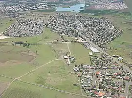 Looking west over Woodberry from 300m above the ground. | |||||||||||||||
Woodberry | |||||||||||||||
| Coordinates | 32°47′24″S 151°40′4″E | ||||||||||||||
| Population | 3,255 (2011 census)[1] | ||||||||||||||
| • Density | 2,310/km2 (6,000/sq mi) [lower-alpha 1] | ||||||||||||||
| Postcode(s) | 2322 | ||||||||||||||
| Area | 8.5 km2 (3.3 sq mi)[lower-alpha 2] | ||||||||||||||
| Time zone | AEST (UTC+10) | ||||||||||||||
| • Summer (DST) | AEDT (UTC+11) | ||||||||||||||
| Location | |||||||||||||||
| LGA(s) | City of Maitland[2] | ||||||||||||||
| Region | Hunter[2] | ||||||||||||||
| County | Northumberland[3] | ||||||||||||||
| Parish | Alnwick[3] | ||||||||||||||
| State electorate(s) | Maitland[4] | ||||||||||||||
| Federal Division(s) | Paterson | ||||||||||||||
| |||||||||||||||
It lies to the west of the Hunter River, 2.4 kilometres (1.5 mi) of which forms the suburb's eastern border, separating it from Heatherbrae and Tomago in the Port Stephens local government area. It is connected by road to the adjoining suburbs of Millers Forest, Beresfield and Tarro. Much of Woodberry is low-lying floodplain and when the Hunter River floods the roads to Millers Forest and Tarro sometimes becomes impassable. However, the residential area is elevated and access to Beresfield remains available.
There is a government co-ed primary school called Woodberry Public School on Lawson Avenue in Wooddberry.[7]
Notes
- This is the average density of the residential part of the suburb where almost all of the population lives, not the average for the whole suburb which is considerably lower at 383/km2 (990/sq mi).
- Area calculation is based on 1:100000 map 9232 NEWCASTLE.
References
- Australian Bureau of Statistics (31 October 2012). "Woodberry (State Suburb)". 2011 Census QuickStats. Retrieved 13 February 2015.

- "Suburb Search - Local Council Boundaries - Hunter (HT) - Maitland City Council". New South Wales Division of Local Government. Retrieved 21 October 2008.
- "Woodberry". Geographical Names Register (GNR) of NSW. Geographical Names Board of New South Wales. Retrieved 18 October 2008.
- "Maitland". New South Wales Electoral Commission. Retrieved 23 November 2019.
- "Woodberry". Land and Property Management Authority - Spatial Information eXchange. New South Wales Land and Property Information. Retrieved 21 October 2008.
- "Investment Property Woodberry, NSW, 2322". Real Estate Investar. Retrieved 12 February 2015.
- "Woodberry Public School". NSW Department of School. Retrieved 9 September 2020.