Wyoming Highway 131
Wyoming Highway 131 (WYO 131) is a 9-mile-long (14 km) north–south Wyoming State Road in Fremont County that travels from U.S. Route 287 (US 287) in Lander, south to Sinks Canyon State Park.
| ||||
|---|---|---|---|---|
| Sinks Canyon Road | ||||
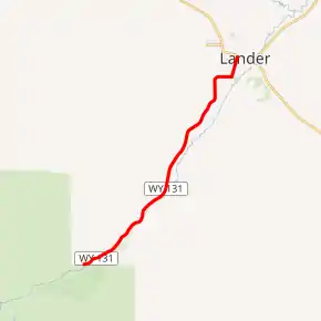
WYO 131 highlighted in red | ||||
| Route information | ||||
| Maintained by WYDOT, City of Lander | ||||
| Length | 9.00 mi[1] (14.48 km) | |||
| Major junctions | ||||
| South end | Sinks Canyon Road in Sinks Canyon State Park | |||
| North end | ||||
| Location | ||||
| Counties | Fremont | |||
| Highway system | ||||
State highways in Wyoming
| ||||

Route description
Wyoming Highway 131 begins its southern end at the northern boundary of the Shoshone National Forest at Sinks Canyon State Park, hence its name Sinks Canyon Road. WYO 131 travels northeast to Lander, entering from the southwest. Upon entering, WYO 131 turns east and becomes Fremont Street before turning north onto South 5th Street.[2] According to the WYDOT 1997 route log, The last 1.68 miles of Highway 131 are maintained by the City of Lander rather than WYDOT.[3] WYO 131 meets its north end when it reaches U.S. Route 287 (Main Street) in Lander. This road was first paved about 1959.
Major intersections
The entire route is in Fremont County.
| Location | mi | km | Destinations | Notes | |
|---|---|---|---|---|---|
| Sinks Canyon State Park | 0.00 | 0.00 | Sinks Canyon Road | Southern terminus of Route 131 | |
| Lander | 9.00 | 14.48 | Northern terminus of Route 131 | ||
| 1.000 mi = 1.609 km; 1.000 km = 0.621 mi | |||||
References
- Wyoming Department of Transportation Reference Marker Book - November 2004 (PDF) (Map). WYDOT. Archived from the original (PDF) on July 17, 2011. Retrieved 2010-07-09.
- Google (8 July 2010). "Overview Map of Wyoming Highway 131" (Map). Google Maps. Google. Retrieved 8 July 2010.
- Wyoming @ AARoads.com - Wyoming Routes 100-199