Wyoming Highway 14
Wyoming Highway 14 (WYO 14) is a 0.36-mile-long (0.58 km) unsigned Wyoming state highway connecting Wyoming Highway 130 with Laramie Regional Airport, just west of Laramie.
| ||||
|---|---|---|---|---|
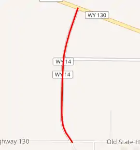
WYO 14 highlighted in red | ||||
| Route information | ||||
| Maintained by WYDOT | ||||
| Length | 0.36 mi[1] (0.58 km) | |||
| Major junctions | ||||
| South end | Laramie Regional Airport near Laramie | |||
| North end | ||||
| Location | ||||
| Counties | Albany | |||
| Highway system | ||||
State highways in Wyoming
| ||||

Route description
Highway 14 may be one of the shortest state-maintained routes in the state, at just 0.36 miles (0.58 km) in length.[1] It connects WYO 130 (Snowy Range Road) with Laramie Regional Airport.[2]
History
Wyoming Highway 14 was the old designation for the current ALT US 14 between Cody and Burgess Junction located in Park and Big Horn Counties in northwestern Wyoming. That routing existed between 1940 and approximately 1965. Confusion between WYO 14 and US 14 caused the Wyoming Highway Department to recommission Wyoming Highway 14 as Alternate US 14.
Major intersections
The entire route is in Albany County.
| Location | mi[1] | km | Destinations | Notes | |
|---|---|---|---|---|---|
| | 0.00 | 0.00 | Southern terminus | ||
| | 0.36 | 0.58 | Northern terminus | ||
| 1.000 mi = 1.609 km; 1.000 km = 0.621 mi | |||||
References
- Maintenance Staff (February 2013). "Maintenance Section Reference Book" (PDF). Wyoming Department of Transportation. Retrieved December 18, 2013.
- Google (August 13, 2016). "Wyoming Highway 14" (Map). Google Maps. Google. Retrieved August 13, 2016.