Wyoming Highway 215
Wyoming Highway 215 (WYO 215) is a 17.19-mile-long (27.66 km) state highway in southeastern Wyoming that runs from its south end in Pine Bluffs north to Albin.
| ||||
|---|---|---|---|---|
| Pine Bluff-Albin Road | ||||
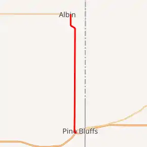
WYO 215 highlighted in red | ||||
| Route information | ||||
| Maintained by WYDOT | ||||
| Length | 17.19 mi[1] (27.66 km) | |||
| Major junctions | ||||
| South end | ||||
| North end | ||||
| Location | ||||
| Counties | Laramie | |||
| Highway system | ||||
State highways in Wyoming
| ||||

Route description
Wyoming Highway 215 begins at I-80 Business/US 30 (Parson Street) just north of exit 401 of I-80/US 30 in Pine Bluffs.[1][2] WYO 215 travels west, crossing Old U.S. 30, as it begins to turn north on the western edge of Pine Bluffs. Named Pine Bluffs-Albin Road, WYO 215 stays due north for the greater part of its routing. At 17.19 miles (27.66 km), Highway 215 reaches its northern terminus at Wyoming Highway 216 near Albin. North of Albin, the roadway continues north as Laramie County Route 162-2 north to Wyoming Highway 151 near LaGrange.[1][2]
Major intersections
The entire route is in Laramie County.
| Location | mi | km | Destinations | Notes | |
|---|---|---|---|---|---|
| Pine Bluffs | 0.00 | 0.00 | Exit 401 (I-80 / US 30) | ||
| Albin | 17.19 | 27.66 | |||
| 1.000 mi = 1.609 km; 1.000 km = 0.621 mi | |||||
References
- Official 2003 State Highway Map of Wyoming
- Wyoming Routes 200-299
- Google (13 November 2016). "Wyoming Highway 215" (Map). Google Maps. Google. Retrieved 13 November 2016.