Laramie County, Wyoming
Laramie County is a county located at the southeast corner of the U.S. state of Wyoming. As of the 2010 United States Census, the population was 91,738, making it the most populous county in Wyoming, but the least populous county in the United States to be the most populous in its state.
Laramie County | |
|---|---|
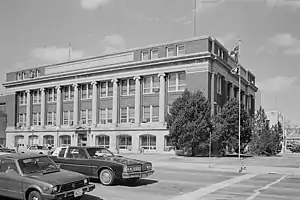 City/County Building at Cheyenne in 1981 | |
 Flag | |
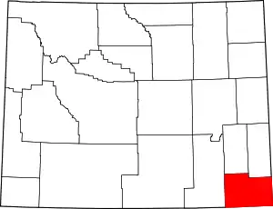 Location within the U.S. state of Wyoming | |
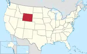 Wyoming's location within the U.S. | |
| Coordinates: 41°19′N 104°41′W | |
| Country | |
| State | |
| Founded | January 9, 1867 |
| Named for | Jacques La Ramee |
| Seat | Cheyenne |
| Largest city | Cheyenne |
| Area | |
| • Total | 2,688 sq mi (6,960 km2) |
| • Land | 2,686 sq mi (6,960 km2) |
| • Water | 1.6 sq mi (4 km2) 0.06%% |
| Population (2010) | |
| • Total | 91,738 |
| • Estimate (2019) | 99,500 |
| • Density | 34/sq mi (13/km2) |
| Time zone | UTC−7 (Mountain) |
| • Summer (DST) | UTC−6 (MDT) |
| Congressional district | At-large |
| Website | laramiecounty |
The county seat is Cheyenne, the state capital.[1] The county lies west of the Nebraska state line and north of the Colorado state line.
Laramie County comprises the Cheyenne, WY Metropolitan Statistical Area.
The city of Laramie, Wyoming, is in neighboring Albany County.
History
Laramie County was originally created in 1867 as a county within the Dakota Territory.[2] The county was named for Jacques La Ramee, a French-Canadian fur-trader.[3] In 1867, a portion of Laramie County was annexed to create Sweetwater County; in 1868; further annexations occurred to create Albany County and Carbon County. Laramie County became a county in the Wyoming Territory when the territorial government was formed in 1869. Crook County was created with land ceded by Laramie County in 1875. In 1888, Converse County was formed from a portion of Laramie County. In 1911, Goshen and Platte Counties were formed from parts of Laramie County, giving the county its current boundaries.
The county's early economy was based on agriculture and livestock raising. The present-day Wyoming Stock Growers Association[4] dates from that era. Other types of animal husbandry also occurred.[5]
Some of the settlers in early Laramie County were foreign immigrants; for example, Burns was largely settled by German immigrants.[5]
Geography
According to the US Census Bureau, the county has a total area of 2,688 square miles (6,960 km2), of which 2,686 square miles (6,960 km2) is land and 1.6 square miles (4.1 km2) (0.06%) is water.[6]
Adjacent counties
- Goshen County – north
- Banner County, Nebraska – northeast
- Kimball County, Nebraska – east
- Weld County, Colorado – south
- Larimer County, Colorado – southwest
- Albany County – west
- Platte County – northwest
Major highways
.svg.png.webp) Interstate 25
Interstate 25.svg.png.webp) Interstate 80
Interstate 80.svg.png.webp) Interstate 180 (Not a freeway.)
Interstate 180 (Not a freeway.) I-25 Bus.
 I-80 Bus.
 U.S. Highway 30
 U.S. Highway 85
 U.S. Highway 87
 Wyoming Highway 210
 Wyoming Highway 211
 Wyoming Highway 212
 Wyoming Highway 213
 Wyoming Highway 214
 Wyoming Highway 215
 Wyoming Highway 216
 Wyoming Highway 219
 Wyoming Highway 221
 Wyoming Highway 222
 Wyoming Highway 223
 Wyoming Highway 225
Demographics
| Historical population | |||
|---|---|---|---|
| Census | Pop. | %± | |
| 1870 | 2,957 | — | |
| 1880 | 6,409 | 116.7% | |
| 1890 | 16,777 | 161.8% | |
| 1900 | 20,181 | 20.3% | |
| 1910 | 26,127 | 29.5% | |
| 1920 | 20,699 | −20.8% | |
| 1930 | 26,845 | 29.7% | |
| 1940 | 33,651 | 25.4% | |
| 1950 | 47,662 | 41.6% | |
| 1960 | 60,149 | 26.2% | |
| 1970 | 56,360 | −6.3% | |
| 1980 | 68,649 | 21.8% | |
| 1990 | 73,142 | 6.5% | |
| 2000 | 81,607 | 11.6% | |
| 2010 | 91,738 | 12.4% | |
| 2019 (est.) | 99,500 | [7] | 8.5% |
| US Decennial Census[8] 1870–2000[9] 2010–2016[10] | |||
2000 census
As of the 2000 United States Census, Laramie County had 81,607 people, 31,927 households, and 21,614 families.[11] The population density was 30 people per square mile (12/km2). The county had 34,213 housing units at an average density of 13 per square mile (5/km2). The racial makeup of the county was 88.92% White, 2.60% Black or African American, 0.85% Native American, 0.95% Asian, 0.11% Pacific Islander, 4.00% from other races, and 2.57% from two or more races. 10.90% of the population were Hispanic or Latino of any race. 23.7% were of German, 11.1% English, 10.3% Irish and 7.4% American ancestry.
As of the 2000 census, Laramie County had 31,927 households, of which 33.20% had children under the age of 18 living with them, 53.90% were married couples living together, 9.90% had a female householder with no husband present, and 32.30% were non-families. 27.20% of all households were made up of a single individual and 8.90% had someone living alone who was 65 years of age or older. The average household size was 2.45 and the average family size was 2.98.
The county population contained 25.80% under the age of 18, 9.60% from 18 to 24, 30.50% from 25 to 44, 22.70% from 45 to 64, and 11.50% who were 65 years of age or older. The median age was 35 years. For every 100 females, the county had 100.90 males. For every 100 females aged 18 and over, the county had 100.00 males.
The median income for a household in the county was $39,607, and the median income for a family was $46,536. Males had a median income of $31,644 versus $24,406 for females. The per capita income for the county was $19,634. About 6.50% of families and 9.10% of the population were below the poverty line, including 12.00% of those under age 18 and 6.50% of those age 65 or over.
2010 census
As of the 2010 United States Census, there were 91,738 people, 37,576 households, and 24,340 families in the county.[12] The population density was 34.2 inhabitants per square mile (13.2/km2). There were 40,462 housing units at an average density of 15.1 per square mile (5.8/km2).[13] The racial makeup of the county was 88.5% white, 2.5% black or African American, 1.1% Asian, 1.0% American Indian, 0.2% Pacific islander, 3.8% from other races, and 3.1% from two or more races. Those of Hispanic or Latino origin made up 13.1% of the population.[12] In terms of ancestry, 29.5% were German, 15.5% were Irish, 12.7% were English, and 4.9% were American.[14]
Of the 37,576 households, 31.9% had children under the age of 18 living with them, 49.3% were married couples living together, 10.7% had a female householder with no husband present, 35.2% were non-families, and 29.1% of all households were made up of individuals. The average household size was 2.40 and the average family size was 2.95. The median age was 37.0 years.[12]
The median income for a household in the county was $52,824 and the median income for a family was $64,589. Males had a median income of $44,001 versus $32,882 for females. The per capita income for the county was $27,406. About 6.7% of families and 9.6% of the population were below the poverty line, including 13.8% of those under age 18 and 4.0% of those age 65 or over.[15]
Communities
City
- Cheyenne (county seat)
Towns
Census-designated places
Unincorporated communities
- Altvan[16]
- Egbert[17]
- Granite
- Horse Creek
- Meriden
Politics and government
Like Wyoming as a whole, Laramie County is strongly Republican. It is extremely conservative for an urban county, having not backed the Democratic presidential candidate since Lyndon Johnson in 1964–one of only two times since 1952 that it has supported a Democrat. In 2016 Hillary Clinton managed to win just 28.3 percent of the vote in the county, the lowest total of any presidential candidate in Laramie since John W. Davis in 1924, when a large proportion of liberal voters defected to Robert M. La Follette, Sr.[18]
| Year | Republican | Democratic | Third parties |
|---|---|---|---|
| 2020 | 62.0% 27,891 | 33.8% 15,217 | 4.2% 1,874 |
| 2016 | 60.7% 24,847 | 28.3% 11,573 | 11.1% 4,549 |
| 2012 | 60.5% 23,904 | 36.2% 14,295 | 3.3% 1,306 |
| 2008 | 59.0% 24,549 | 38.6% 16,072 | 2.4% 1,004 |
| 2004 | 65.1% 25,951 | 33.0% 13,171 | 1.9% 757 |
| 2000 | 61.7% 21,797 | 34.4% 12,162 | 3.9% 1,364 |
| 1996 | 50.0% 16,924 | 40.4% 13,676 | 9.7% 3,269 |
| 1992 | 40.5% 12,890 | 38.2% 12,177 | 21.3% 6,788 |
| 1988 | 56.0% 15,561 | 42.7% 11,851 | 1.3% 358 |
| 1984 | 64.9% 19,348 | 33.9% 10,110 | 1.1% 341 |
| 1980 | 55.4% 15,361 | 34.3% 9,512 | 10.3% 2,840 |
| 1976 | 53.5% 14,061 | 45.8% 12,040 | 0.7% 193 |
| 1972 | 65.7% 15,010 | 34.1% 7,791 | 0.2% 54 |
| 1968 | 46.8% 9,824 | 45.4% 9,519 | 7.9% 1,649 |
| 1964 | 34.8% 8,563 | 65.2% 16,059 | |
| 1960 | 49.1% 11,637 | 51.0% 12,086 | |
| 1956 | 53.8% 10,581 | 46.2% 9,072 | |
| 1952 | 56.6% 10,785 | 43.0% 8,187 | 0.4% 79 |
| 1948 | 42.7% 6,200 | 56.6% 8,226 | 0.7% 98 |
| 1944 | 49.3% 7,326 | 50.7% 7,542 | |
| 1940 | 43.1% 5,955 | 56.5% 7,808 | 0.4% 57 |
| 1936 | 35.9% 4,356 | 62.6% 7,594 | 1.6% 190 |
| 1932 | 46.8% 5,116 | 49.7% 5,435 | 3.5% 387 |
| 1928 | 65.3% 5,862 | 33.8% 3,029 | 0.9% 82 |
| 1924 | 53.0% 3,944 | 15.1% 1,120 | 32.0% 2,378 |
| 1920 | 62.6% 3,399 | 33.3% 1,810 | 4.1% 221 |
| 1916 | 45.6% 2,428 | 51.9% 2,759 | 2.5% 133 |
| 1912 | 39.0% 1,871 | 40.0% 1,923 | 21.0% 1,010 |
| 1908 | 52.7% 2,965 | 44.8% 2,523 | 2.6% 144 |
| 1904 | 69.8% 3,109 | 26.2% 1,167 | 4.0% 180 |
| 1900 | 58.6% 2,181 | 41.4% 1,538 | |
| 1896 | 51.9% 1,776 | 47.6% 1,628 | 0.6% 19 |
| 1892 | 57.5% 1,890 | 42.5% 1,398 |
See also
References
- "Find a County". National Association of Counties. Retrieved June 7, 2011.
- Long, John H. (2006). "Wyoming: Individual County Chronologies". Wyoming Atlas of Historical County Boundaries. The Newberry Library. Archived from the original on July 18, 2011. Retrieved September 1, 2011.
- Urbanek, Mae (1988). Wyoming Place Names. Missoula MT: Mountain Press Pub. Co. ISBN 0-87842-204-8.
- Osgood, Ernest Staples. The Day of the Cattleman. Chicago: University of Chicago Press, 1929. Print. pp. 120-121
- Herman, Marguerite. "Laramie County WY". Wyoming State Historical Society. Retrieved April 17, 2014.
- "2010 Census Gazetteer Files". US Census Bureau. August 22, 2012. Retrieved August 18, 2015.
- "Population and Housing Unit Estimates". Retrieved September 28, 2019.
- "US Decennial Census". US Census Bureau. Retrieved August 18, 2015.
- "Historical Decennial Census Population for Wyoming Counties, Cities, and Towns". Wyoming Department of Administration & Information, Division of Economic Analysis. Retrieved January 25, 2014.
- "State & County QuickFacts". US Census Bureau. Archived from the original on July 3, 2011. Retrieved January 25, 2014.
- "U.S. Census website". US Census Bureau. Retrieved May 14, 2011.
- "Profile of General Population and Housing Characteristics: 2010 Demographic Profile Data". US Census Bureau. Archived from the original on February 13, 2020. Retrieved January 12, 2016.
- "Population, Housing Units, Area, and Density: 2010 - County". US Census Bureau. Archived from the original on February 13, 2020. Retrieved January 12, 2016.
- "Selected Social Characteristics in the US – 2006-2010 American Community Survey 5-Year Estimates". US Census Bureau. Archived from the original on February 13, 2020. Retrieved January 12, 2016.
- "Selected Economic Characteristics – 2006-2010 American Community Survey 5-Year Estimates". US Census Bureau. Archived from the original on February 13, 2020. Retrieved January 12, 2016.
- Altvan WY Google Maps (accessed 10 January 2019)
- Egbert WY Google Maps (accessed 10 January 2019)
- Leip, David. "Atlas of US Presidential Elections". uselectionatlas.org. Retrieved April 5, 2018.
Further reading
- Hallberg, L.L. and J.P. Mason. (2007). Selected hydrogeologic data for the High Plains aquifer in southwestern Laramie County WY, 1931-2006 [US Geological Survey Open-File Report 2007-1069]. Reston VA: US Dept of the Interior, US Geological Survey.
External links
![]() Media related to Laramie County, Wyoming at Wikimedia Commons
Media related to Laramie County, Wyoming at Wikimedia Commons
Places adjacent to Laramie County, Wyoming | |
|---|---|
Municipalities and communities of Laramie County, Wyoming, United States | ||
|---|---|---|
| City | | |
| Towns | ||
| CDPs | ||
| Unincorporated communities | ||
| ||

| Authority control |
|---|