Wyoming Highway 319
Wyoming Highway 319 (WYO 319) is a 28.75-mile-long (46.27 km) north-south state road in Platte and Converse counties.
| ||||||||||
|---|---|---|---|---|---|---|---|---|---|---|
| Old Yellowstone Highway | ||||||||||
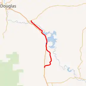
WYO 319 in red, WYO 319 Spur in blue | ||||||||||
| Route information | ||||||||||
| Maintained by WYDOT | ||||||||||
| Length | 28.75 mi[1] (46.27 km) | |||||||||
| Major junctions | ||||||||||
| South end | ||||||||||
| North end | ||||||||||
| Location | ||||||||||
| Counties | Platte, Converse | |||||||||
| Highway system | ||||||||||
State highways in Wyoming
| ||||||||||

Route description
Wyoming Highway 319 is a north–south highway that follows the old Yellowstone Highway, therefore the current highway is named Old Yellowstone Highway. WYO 319 begins its south end at I-25 (exit 100) and from there heads northeast then north towards Glendo. At 6.21 miles (9.99 km) WYO 319 intersects a local road which heads west to exit 104 off I-25. Still heading north WYO 319 enters Glendo from the south, intersecting A Street at 14.16 miles (22.79 km). A Street is designated as WYO 319 Spur for 0.2 miles (0.32 km) between WYO 319 and Interstate 25 (exit 111). As Highway 319 leaves Glendo, at 15.4 miles (24.8 km) there is a road named Lake Shore Road that east of WYO 319 and allows access to Glendo State Park. Glendo State Park is one of Wyoming's most popular boating parks, and it offers visitors water-skiing, fishing, and other water-based activities as well as campsites, sanitary facilities, tables and grills.[2] Wyoming Highway 319 heads northwest and parallels Interstate 25 that lies to the west and the Glendo Reservoir/North Platte River that lies to the east. I-25 breaks its parallel and leaves to head more northwest towards Douglas, while Highway 319 turns north to come to an end at US 18/US 20 in Orin at 28.84 miles (46.41 km).[3][4]
History
Wyoming Highway 319 is the original alignment of Old US 185 between 1926 and 1936.[5] and US 87 (Yellowstone Highway) from 1936 until Interstate 25 was completed (between 1956 and the 1980s) and therefore routed along it.[6]
Major intersections
| County | Location | mi | km | Destinations | Notes |
|---|---|---|---|---|---|
| Platte | | 0.00 | 0.00 | I-25 / US 26 / US 87 – Wheatland, Glendo | Southern terminus; I-25 exit 100 |
| Glendo | 14.60 | 23.50 | |||
| Converse | Orin | 28.75 | 46.27 | Northern terminus | |
| 1.000 mi = 1.609 km; 1.000 km = 0.621 mi | |||||
Wyoming Highway 319 Spur
| |
|---|---|
| Location | Glendo |
| Length | 0.20 mi[1] (0.32 km) |
Wyoming Highway 319 Spur is an unsigned 0.20-mile (0.3 km) long spur route of WYO 319 in Glendo. Wyoming Highway 319 Spur runs from WYO 319 west to Interstate 25/US 87 (exit 111) at the Glendo Interchange.
References
- Wyoming Department of Transportation Reference Marker Book - November 2004 (PDF) (Map). WYDOT. Archived from the original (PDF) on July 17, 2011. Retrieved 2011-03-31.
- "Glendo State Park".
- "Wyoming State Route Log: 300 through 399". AARoads.
- Google (26 December 2016). "Wyoming Highway 319" (Map). Google Maps. Google. Retrieved 26 December 2016.
- "Wyoming @ AARoads - U.S. Highway 185 (Decommissioned)". www.aaroads.com.
- "Wyoming @ AARoads - U.S. Highway 87". www.aaroads.com.
- Official 2003 State Highway Map of Wyoming
