Yantarni Volcano
Yantarni Volcano is an andesitic stratovolcano in the U.S. state of Alaska. It is on the Alaska Peninsula, in the Aleutian Range, between Mount Aniakchak and Mount Chiginagak volcanoes.[1] The volcano was not discovered until 1979 due to its remote location, lack of documented historic activity, and its rather modest summit elevation. The mountain was named after nearby Yantarni Bay, which in turn was named by Russian explorers after the abundance of yantar in the area.[2]
| Yantarni | |
|---|---|
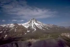 Yantarni volcano, September 1985 | |
| Highest point | |
| Elevation | 4,383 ft (1,336 m) |
| Coordinates | 57°01′05″N 157°11′00″W |
| Geography | |
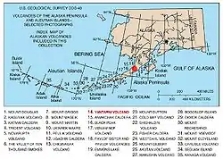
| Location | Alaska Peninsula, Alaska, U.S. |
| Parent range | Aleutian Range |
| Topo map | USGS Ugashik A-4 |
| Geology | |
| Mountain type | Stratovolcano |
| Volcanic arc/belt | Aleutian Arc |
| Last eruption | 800 BCE ± 500 years |
Geology
The current cycle of eruptive activity began in middle Pleistocene time with extrusion of andesitic lava flows, perhaps from multiple vents. By the late Pleistocene, central-vent volcanism had initiated construction of a small stratovolcano.[3]
800 BCE ± 500 years eruption
The cone was breached sometime in the late Holocene, between 2 and 3.5 ka, during the only Holocene event.[4] The eruption was similar to that of Mount St. Helens.[5] and was followed by the emplacement of 1 cu km of pyroclastic flows related to growth of the summit lava dome.[6] It had a Volcanic Explosivity Index of 5[7]
Notes
- "Yantarni". Global Volcanism Program. Smithsonian Institution.
- "Yantarni - Introduction". Alaska Volcano Observatory. Retrieved 31 October 2010.
- "Yantarni description and statistics". Alaska Volcano Observatory. Retrieved 2009-06-13.
- "Yantarni description and statistics". Alaska Volcano Observatory. Retrieved 2009-06-13.
- Yantarni Volcano - Volcanolive.com
- "Yantarni". Global Volcanism Program. Smithsonian Institution.
- "Yantarni (Eruptive History)". Global Volcanism Program. Smithsonian Institution. Retrieved 2009-06-13.