Yawal
Yawal is a taluka, city and a municipal council in Jalgaon, Maharashtra, India.
Yawal | |
|---|---|
city | |
 Yawal Location in Maharashtra, India | |
| Coordinates: 21.1667°N 75.7°E | |
| Country | |
| State | Maharashtra |
| District | Jalgaon |
| Population (2011)[1] | |
| • Total | 45,000 |
| Languages | |
| • Official | Marathi |
| Time zone | UTC+5:30 (IST) |
| PIN | 425301 |
| Telephone code | 02585 |
| Vehicle registration | MH-19 |
Geography
Yawal has 1 river {Sur river} with 2 tributaries, (Harita and Sarita a.k.a. Hadkai and Khadkai). Yawal taluka consists of Atrawal, Kingaon, Anjale, Amoda, Sakali, Faizpur, Sangavi Bk, Nhavi, Korpawali, Haripura, Viravali and many other villages.
Demographics
Zhambre-Deshmukhs was the head of Yawal Pargana. They had received Yawal as a Jagir.
Politics
Yawal is also a taluka city in the district of Jalgaon, Maharashtra. The Yawal city is divided into 19 wards for which elections are held every 5 years. The Yawal Municipal Council has a population of 36,706 of which 18,965 are males while 17,741 are females as per report released by Census India 2011. Yawal Municipal Council has total administration over 7,363 houses to which it supplies basic amenities like water and sewerage.
Transport
Yawal is located on the Burhanpur-Ankaleshwer MH SH 4. The nearest main railway station is Bhusawal which is just 18 km. The nearest airport to Yawal is Jalgaon Airport which is just 45 km away.
Temples
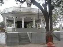
- Shree Jagatguru Ved Maharshi Vyas Muni Mandir. He wrote the Mahabharata.
- Tarkeshwar Mandir.
It has a fort said to have belonged to the Sansthanik Raje Nimbalkar.[2] Gavali Wadaa has a 9–10 km long wall.
References
- "Search details". Census India. Retrieved 18 August 2017.
- "Gazetteer of the Bombay Presidency: Khandesh". Printed at the Government Central Press. 18 August 1880. Retrieved 18 August 2017 – via Google Books.
Jalgaon district topics | ||
|---|---|---|
| History | 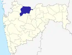 | |
| Tehsils | ||
| Lok Sabha constituencies | ||
| Vidhan Sabha constituencies | ||
| Towns and villages |
| |
| Places of interest | ||
