Ōe, Yamagata
Ōe (大江町, Ōe-machi) is a town located in Yamagata Prefecture, Japan. As of 1 February 2020, the town had an estimated population of 7,894 in 2828 households,[1] and a population density of 51 persons per km2. The total area of the town is 153.92 square kilometres (59 sq mi).
Ōe
大江町 | |
|---|---|
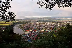 Aterazawa neighborhood of Ōe | |
 Flag  Seal | |
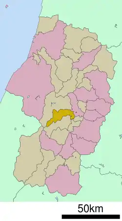 Location of Ōe in Yamagata Prefecture | |
 Ōe | |
| Coordinates: 38°22′50.7″N 140°12′24.5″E | |
| Country | Japan |
| Region | Tōhoku |
| Prefecture | Yamagata |
| District | Nishimurayama |
| Area | |
| • Total | 153.92 km2 (59.43 sq mi) |
| Population (February 2020) | |
| • Total | 7,894 |
| • Density | 51/km2 (130/sq mi) |
| Time zone | UTC+9 (Japan Standard Time) |
| City symbols | |
| • Tree | Cryptomeria |
| • Flower | Hydrangea macrophylla |
| • Bird | Crested kingfisher |
| • Fish | Masu salmon |
| Phone number | 0237-62-2111 |
| Address | 882-1 Aterazawa, Ōe-machi, Nishimurayama-gun, Yamagata-ken 990-1101 |
| Website | Official website |
Geography
Ōe is located in mountainous central Yamagata. Like many small towns in Japan, Ōe is a collection of smaller hamlets. Elevation rises and populations decrease from east to west. The easternmost hamlet is Aterazawa, and contains about 4/5 of the town's population. The town extends from the west end of the central part of the Yamagata basin to the Asahi Mountains. In addition, it has several enclaves in Sagae city and Nakayama town, bordering the east. Administratively, the town area is divided from the east into the Sazawa, Hongo, and Shichiken districts. The Mogami River forms the eastern border of the town.
Demographics
Per Japanese census data,[2] the population of Ōe peaked around 1950, and has been steadily decreasing since. The population is now much less than it was a hundred years ago.
| Year | Pop. | ±% |
|---|---|---|
| 1920 | 12,619 | — |
| 1930 | 13,879 | +10.0% |
| 1940 | 13,987 | +0.8% |
| 1950 | 17,159 | +22.7% |
| 1960 | 15,819 | −7.8% |
| 1970 | 13,126 | −17.0% |
| 1980 | 11,374 | −13.3% |
| 1990 | 10,724 | −5.7% |
| 2000 | 10,477 | −2.3% |
| 2010 | 9,229 | −11.9% |
Climate
Ōe has a humid continental climate (Köppen climate classification Cfa) with large seasonal temperature differences, with warm to hot (and often humid) summers and cold (sometimes severely cold) winters. Precipitation is significant throughout the year, but is heaviest from August to October. The average annual temperature in Ōe is 10.2 °C. The average annual rainfall is 1681 mm with September as the wettest month. The temperatures are highest on average in August, at around 24.1 °C, and lowest in January, at around -2.5 °C.[3]
| Climate data for Ōe (Aterizawa station) | |||||||||||||
|---|---|---|---|---|---|---|---|---|---|---|---|---|---|
| Month | Jan | Feb | Mar | Apr | May | Jun | Jul | Aug | Sep | Oct | Nov | Dec | Year |
| Record high °C (°F) | 12.3 (54.1) |
15.9 (60.6) |
20.7 (69.3) |
29.5 (85.1) |
32.3 (90.1) |
33.9 (93.0) |
36.2 (97.2) |
36.7 (98.1) |
34.7 (94.5) |
27.9 (82.2) |
25.7 (78.3) |
19.0 (66.2) |
36.7 (98.1) |
| Average high °C (°F) | 2.0 (35.6) |
2.9 (37.2) |
7.1 (44.8) |
15.3 (59.5) |
21.3 (70.3) |
24.7 (76.5) |
27.6 (81.7) |
29.6 (85.3) |
24.7 (76.5) |
18.5 (65.3) |
11.5 (52.7) |
5.4 (41.7) |
15.9 (60.6) |
| Daily mean °C (°F) | −1.5 (29.3) |
−1.1 (30.0) |
2.0 (35.6) |
8.6 (47.5) |
14.4 (57.9) |
18.8 (65.8) |
22.3 (72.1) |
23.7 (74.7) |
19.0 (66.2) |
12.4 (54.3) |
6.2 (43.2) |
1.4 (34.5) |
10.5 (50.9) |
| Average low °C (°F) | −4.9 (23.2) |
−5.1 (22.8) |
−2.5 (27.5) |
2.3 (36.1) |
7.8 (46.0) |
13.7 (56.7) |
18.1 (64.6) |
19.2 (66.6) |
14.6 (58.3) |
7.4 (45.3) |
1.7 (35.1) |
−2.0 (28.4) |
5.9 (42.6) |
| Record low °C (°F) | −15.4 (4.3) |
−16.2 (2.8) |
−13.6 (7.5) |
−6.9 (19.6) |
−1.0 (30.2) |
4.4 (39.9) |
8.5 (47.3) |
10.3 (50.5) |
3.8 (38.8) |
−2.1 (28.2) |
−7.5 (18.5) |
−16.3 (2.7) |
−16.3 (2.7) |
| Average precipitation mm (inches) | 128.9 (5.07) |
98.7 (3.89) |
87.9 (3.46) |
72.6 (2.86) |
83.1 (3.27) |
115.8 (4.56) |
175.1 (6.89) |
136.5 (5.37) |
124.0 (4.88) |
101.5 (4.00) |
123.9 (4.88) |
132.5 (5.22) |
1,378.3 (54.26) |
| Average snowfall cm (inches) | 238 (94) |
200 (79) |
85 (33) |
2 (0.8) |
0 (0) |
0 (0) |
0 (0) |
0 (0) |
0 (0) |
0 (0) |
6 (2.4) |
95 (37) |
618 (243) |
| Average precipitation days (≥ 1 mm) | 21.0 | 18.4 | 16.7 | 11.7 | 10.0 | 10.6 | 13.5 | 10.2 | 12.5 | 12.7 | 16.0 | 20.3 | 173.2 |
| Mean monthly sunshine hours | 68.5 | 89.9 | 141.7 | 179.6 | 194.0 | 157.2 | 149.5 | 179.3 | 128.9 | 129.3 | 94.8 | 67.1 | 1,581.4 |
| Source: Japan Meteorological Agency [4][5] | |||||||||||||
History
The area of present-day Ōe was part of ancient Dewa Province. During the Kamakura period it was controlled by the Ōe clan. During the early Edo period, it was the site of a castle and center of the briefly-lived Aterazawa Domain (12,000 koku), which was absorbed into Tsuruoka Domain. After the start of the Meiji period, the area became part of Nishimurayama District, Yamagata Prefecture. The village of Aterizawa was established on April 1, 1889 with the establishment of the modern municipalities system. The town of Ōe was established on August 20, 1959 by the merger of the town of Aterazawa and the village of Urushikawa.
Economy
The economy of Ōe is based on agriculture.
Education
Ōe has two public elementary schools and one public middle school operated by the Town government and one public high schools operated by the Yamagata Prefectural Board of Education.
Transportation
Highway
Local attractions
Events
- Oe Doll's Festival (March)
- Mogami River rower's song contest (June)
Landmarks
- Tateyama Park(ruin of The Tateyama castle)
- Yanagawa spa
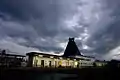
 Oe Office
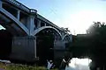 Mogami Bridge
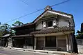 Aterazawa Haramachi
 Kokain Temple
 Yanagawa spa
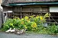 Duck family
References
- Ōe Town official statistics (in Japanese)
- Ōe population statistics
- Ōe climate data
- "左沢観測所 平年値(年・月ごとの値)". 気象庁. Retrieved 2017-11-16.
- "左沢観測所 観測史上1~10位の値(年間を通じての値)". 気象庁. Retrieved 2017-11-16.
External links
![]() Media related to Ōe, Yamagata at Wikimedia Commons
Media related to Ōe, Yamagata at Wikimedia Commons
- Official website (in Japanese)
| Core city | ||
|---|---|---|
| Cities | ||
| Districts | ||
| Authority control |
|---|
