Shōnai, Yamagata
Shōnai (庄内町, Shōnai-machi) is a town located in Yamagata Prefecture, Japan. As of 29 February 2020, the town has an estimated population of 20,940 in 7108 households,[1] and a population density of 87.5 per km². The total area of the town is 249.17 square kilometres (96 sq mi).
Shōnai
庄内町 | |
|---|---|
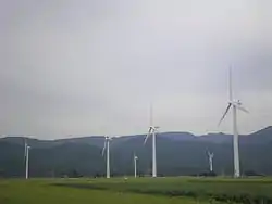 Wind farm in Shonai | |
 Flag  Seal | |
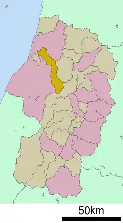 Location of Shōnai in Yamagata Prefecture | |
 Shōnai | |
| Coordinates: 38°50′59.6″N 139°54′17″E | |
| Country | Japan |
| Region | Tōhoku |
| Prefecture | Yamagata |
| District | Higashitagawa |
| Area | |
| • Total | 249.17 km2 (96.21 sq mi) |
| Population (February 2020) | |
| • Total | 20,940 |
| • Density | 84/km2 (220/sq mi) |
| Time zone | UTC+9 (Japan Standard Time) |
| - Tree | Camellia japonica |
| - Flower | Fritillaria camschatcensis |
| - Bird | Eurasian skylark |
| Phone number | 0234-43-2211 |
| Address | 132-1 Amarume-cho, Shōnai-machi, Higashitagawa-gun, Yamagata-ken 999-7781 |
| Website | Official website |
Geography
Shōnai is located in the coastal plains of north-central Yamagata Prefecture. The Mogami River flows through the town. Mount Gassan, the highest of the Three Mountains of Dewa is at the intersection of the borders of Shōnai, Tsuruoka, Ōkura and Nishikawa.
Demographics
Per Japanese census data,[2] the population of Shōnaipeaked around the year 1950, and has gradually been decreasing over the past 70 years. It is now less than it was a hundred years ago.
| Year | Pop. | ±% |
|---|---|---|
| 1920 | 25,848 | — |
| 1930 | 28,224 | +9.2% |
| 1940 | 29,310 | +3.8% |
| 1950 | 33,961 | +15.9% |
| 1960 | 33,160 | −2.4% |
| 1970 | 28,925 | −12.8% |
| 1980 | 27,798 | −3.9% |
| 1990 | 26,705 | −3.9% |
| 2000 | 25,489 | −4.6% |
| 2010 | 23,158 | −9.1% |
Climate
Shōnai has a Humid continental climate (Köppen climate classification Cfa) with large seasonal temperature differences, with warm to hot (and often humid) summers and cold (sometimes severely cold) winters. Precipitation is significant throughout the year, but is heaviest from August to October. The average annual temperature in Shōnai is 11.4 °C. The average annual rainfall is 1917 mm with September as the wettest month. The temperatures are highest on average in August, at around 24.9 °C, and lowest in January, at around -0.6 °C.[3]
History
The area of present-day Shōnai was part of ancient Dewa Province. After the start of the Meiji period, the area became part of Higashitagawa District, Yamagata Prefecture. The town of Amarume was established on April 1, 1889, with the creation of the modern municipalities system, and the town of Karikawa on April 1, 1937. Karikawa merged with the neighboring villages of Kiyokawa and Tachiyazawa on October 1, 1954, and was renamed Tachikawa. On July 1, 2005, the towns of Tachikawa and Amarume merged to form the new town of Shōnai.
Economy
The economy of Shōnai is based on agriculture.
Education
Shōnai has five public elementary schools and two public middle schools operated by the town government, and one public high school operated by the Yamagata Prefectural Board of Education.
References
- Shōnai Town official statistics (in Japanese)
- Shōnai population statistics
- Shōnai climate data
- "International Exchange". List of Affiliation Partners within Prefectures. Council of Local Authorities for International Relations (CLAIR). Retrieved 21 November 2015.
External links
| Wikimedia Commons has media related to Shōnai, Yamagata. |
- Official website (in Japanese)