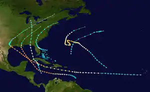
1915 Atlantic hurricane season
The 1915 Atlantic hurricane season ran through the summer and the first half of fall in 1915. It was an inactive season, with only ten tropical cyclones, six tropical storms, and five hurricanes, but it featured a high number of major hurricanes, with two Category 4 hurricanes devastating the Gulf Coast of the United States. The season began early, with a tropical depression forming in late April. The first storm, though, formed very late, not until the end of July. The last storm dissipated at one of the earliest dates on record, September 30, though there were also two tropical depressions in October.
| 1915 Atlantic hurricane season | |
|---|---|
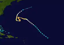
 Season summary map | |
| Seasonal boundaries | |
| First system formed | April 29, 1915 |
| Last system dissipated | October 22, 1915 |
| Strongest storm | |
| Name | "New Orleans" |
| • Maximum winds | 145 mph (230 km/h) (1-minute sustained) |
| • Lowest pressure | 931 mbar (hPa; 27.49 inHg) |
| Seasonal statistics | |
| Total depressions | 10 |
| Total storms | 6 |
| Hurricanes | 5 |
| Major hurricanes (Cat. 3+) | 3 |
| Total fatalities | 675 total |
| Total damage | $63 million (1915 USD) |
| Related article | |
| |
Timeline

Systems
The 1915 season was not very active in terms of the number of storms but it was fairly eventful, with two powerful hurricanes hitting the Gulf Coast of the United States.
Hurricane One
| Category 1 hurricane (SSHWS) | |
  | |
| Duration | July 31 – August 4 |
|---|---|
| Peak intensity | 75 mph (120 km/h) (1-min) 990 mbar (hPa) |
The first storm of the season developed quickly off the coast of Central Florida,[1] beginning as a tropical storm early on July 31 and reaching hurricane intensity the following day as it approached the state.[2] At 18:00 UTC on August 1, the small hurricane made landfall near Titusville, Florida, at peak strength with winds of 75 mph (121 km/h).[3] It then weakened and curved towards the northeast, taking a track across the Appalachian Mountains as a tropical storm.[2] Slight reintensification occurred as it approached the Mid-Atlantic states, perhaps aided by baroclinic influences. Late on August 4, the system became extratropical upon merging with a frontal boundary,[3] and later dissipated the following day.[2]
Ahead of the hurricane's landfall, storm warnings were issued by the Weather Bureau from Jacksonville, Florida, to Fort Monroe, Virginia, and were later extended north to Boston, Massachusetts, once the storm began progressing along the U.S. East Coast.[1] At landfall, the strongest winds occurred east of the Suwannee River, reaching 45 mph (72 km/h) in Jacksonville. Bridges, highways, and railways were damaged by the hurricane, and some buildings were toppled.[3] The Florida East Coast Railway between Titusville and Miami, Florida, was significantly damaged.[4] The system also dropped heavy rainfall across portions of Florida, with a maximum of 16.61 inches (422 mm) recorded at St. Petersburg.[5] Combined with the strong winds, the rain caused severe damage to crops. The damage toll was estimated to be at least $250,000. Gusty winds accompanied the storm along coastal regions of the northeastern United States, including a 53 mph (85 km/h) wind recorded in New York City.[3]
Hurricane Two
| Category 4 hurricane (SSHWS) | |
  | |
| Duration | August 5 – August 19 |
|---|---|
| Peak intensity | 145 mph (230 km/h) (1-min) 940 mbar (hPa) |
The Galveston Hurricane of 1915 or Hurricane San Triburcio of 1915
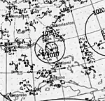
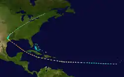
The second storm of the year was first observed in the eastern Tropical Atlantic on August 5. It tracked westward, intensifying into a hurricane on the 9th before crossing the Lesser Antilles on the 10th. As the hurricane continued through the Caribbean Sea, it passed just south of Puerto Rico and Hispaniola before crossing Jamaica on August 13 where it caused heavy damage. While south of Cuba it rapidly intensified, and it brushed the western tip of the country on August 15 as a strong Category 4 hurricane. Over the Gulf of Mexico the hurricane weakened slightly. It made landfall near Galveston, Texas, as a low-end Category 4 hurricane on August 17. It turned northward, became extratropical on August 18, and dissipated on August 23. Just fifteen years after the 1900 Galveston Hurricane, this hurricane damaged the already hurting Texas economy. Throughout its path, it caused a total of $50 million in damage (1915 USD, $921 million in 2005 USD) and 400 casualties.
Hurricane Three
| Category 3 hurricane (SSHWS) | |
 | |
| Duration | August 27 – September 10 |
|---|---|
| Peak intensity | 120 mph (195 km/h) (1-min) 985 mbar (hPa) |
Hurricane Three, which was first observed on August 28 in the central Tropical Atlantic, tracked northwestward to reach a peak of 120 mph winds. It stalled and drifted south near Bermuda, bringing heavy surf and moderate damage to the island. The hurricane turned to the west, north, and finally recurved out to sea, becoming extratropical on September 10.
Hurricane Four
| Category 2 hurricane (SSHWS) | |
 | |
| Duration | August 31 – September 6 |
|---|---|
| Peak intensity | 100 mph (155 km/h) (1-min) 982 mbar (hPa) |
On August 31, a tropical storm developed southwest of Jamaica. It headed north-northwestward, strengthening to a Category 2 hurricane as it made landfall on western Cuba. It weakened to 90 mph (130 km/h) winds when it hit near Apalachicola, Florida, on September 4. The storm continued northward and dissipated on September 9 over southern Michigan. Well-executed warnings kept the death toll to 0, and the hurricane only caused minor to moderate damage with high tides occurring.
Tropical Storm Five
| Tropical storm (SSHWS) | |
 | |
| Duration | September 19 – September 22 |
|---|---|
| Peak intensity | 60 mph (95 km/h) (1-min) <1005 mbar (hPa) |
This strong tropical storm remained over the open ocean.[3]
Hurricane Six
| Category 4 hurricane (SSHWS) | |
 | |
| Duration | September 21 – September 30 |
|---|---|
| Peak intensity | 145 mph (230 km/h) (1-min) 931 mbar (hPa) |
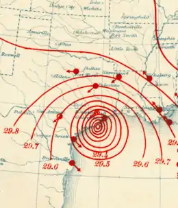
The New Orleans Hurricane of 1915
The sixth and final storm of the year was first seen just west of the Lesser Antilles on September 22. It tracked through the Caribbean, strengthening to its peak of 145 mph (230 km/h) on September 25.[3] On September 29, it made landfall near Grand Isle as a strong Category 3 hurricane.[3]
A barometric reading of 951 mbar (28.11 inHg) was at the time the lowest ever measured on land in the United States. The storm caused severe flooding and killed 275 people, a number possibly reduced to well-executed warnings. Winds tore off roofs and damaged buildings in New Orleans, where pressure was measured at down to 28.01" and a wind speed of 98 mph. Generations in south east Louisiana would refer to it as the Great Storm of 1915. Property damage in Louisiana was estimated at $13 million (1915 USD, $239 million in 2005 USD), with $5 million of that in the city of New Orleans.
References
- Frankenfield, H. C. (August 1915). "Forecasts and Warnings for August 1915, Washington, D.C. District" (PDF). Monthly Weather Review. Silver Spring, Maryland: National Oceanic and Atmospheric Administration. 43 (8): 404–405. doi:10.1175/1520-0493(1915)43<404:FAWFAW>2.0.CO;2.

- "Atlantic hurricane best track (HURDAT version 2)" (Database). United States National Hurricane Center. May 25, 2020.
- Hurricane Research Division. "HURDAT Meta-Data". NOAA. Archived from the original on 16 March 2008. Retrieved 2008-02-15.
- Mitchell, Alexander J. (August 1915). "Florida Section" (PDF). Climatological Data. Asheville, North Carolina: National Centers for Environmental Information. 19 (8): 59. Retrieved August 15, 2019.
- United States Army Corps of Engineers (1945). Storm Total Rainfall In The United States. War Department. p. SA 4–15.
External links
| Wikimedia Commons has media related to 1915 Atlantic hurricane season. |