1972 North Indian Ocean cyclone season
The 1972 North Indian Ocean cyclone season was part of the annual cycle of tropical cyclone formation. The season had no official bounds, but cyclones tend to form between April and December. These dates conventionally delimit the period of each year when most tropical cyclones form in the northern Indian Ocean. There are two main seas in the North Indian Ocean—the Bay of Bengal to the east of the Indian subcontinent and the Arabian Sea to the west of India. The official Regional Specialized Meteorological Centre in this basin is the India Meteorological Department (IMD), while the Joint Typhoon Warning Center (JTWC) releases unofficial advisories. An average of five tropical cyclones form in the North Indian Ocean every season with peaks in May and November.[1] Cyclones occurring between the meridians 45°E and 100°E are included in the season by the IMD.[2]
| 1972 North Indian Ocean cyclone season | |
|---|---|
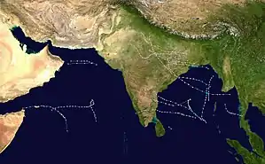 Season summary map | |
| Seasonal boundaries | |
| First system formed | Unknown |
| Last system dissipated | Unknown |
| Seasonal statistics | |
| Deep depressions | 18 |
| Cyclonic storms | 7 |
| Severe cyclonic storms | 6 |
| Total fatalities | Unknown |
| Total damage | Unknown |
| Related articles | |
Systems
September 1972 Andhra Pradesh cyclone
| Extremely severe cyclonic storm (IMD) | |
| Category 4 tropical cyclone (SSHWS) | |
 | |
| Duration | September 7 – September 14 |
|---|---|
| Peak intensity | 205 km/h (125 mph) (3-min) |
This cyclone was formed on 7 September. It had an explosive intensification upto Extremely Severe Cyclonic Storm and Category 4 equivalent cyclone. The storm made landfall at Ichhapuram in Andhra Pradesh on 10 September. Due to the storm, 100 people and 8000 cattle were perished.[3] Puri in Odisha recorded gust winds upto 185 kmph. Heavy damages to agricultural crops took place at Odisha and Andhra Pradesh. Nearly 2 lakh people were affected by the storm. Ganjam District in Odisha was the worst affected by the storm. It was the most intense cyclone to hit India in the month of September.
December 1972 Tamil Nadu cyclone
| Very severe cyclonic storm (IMD) | |
| Category 1 tropical cyclone (SSHWS) | |
 | |
| Duration | December 1 – December 8 |
|---|---|
| Peak intensity | 155 km/h (100 mph) (3-min) |
This system was formed on 1 December. It reached its peak intensity of Very Severe Cyclonic Storm and Category 1 equivalent Cyclone on 4 December. By the next day, the storm made landfall between Puducherry and Cuddalore in Tamil Nadu and its remnants tracked till the coast of Kerala and dissipated on 8 December. The storm killed 80 people and 150 cattle. 30,000 people were rendered homeless. Cuddalore recorded gust winds up to 150 kmph at the time of landfall. Total damages in Indian Rupees were estimated to be 40 crores.[4] The cyclone is visible on The Blue Marble photo taken by Apollo 17.
See also
- List of North Indian Ocean cyclone seasons
- 1972 Atlantic hurricane season
- 1972 Pacific hurricane season
- 1972 Pacific typhoon season
- Australian cyclone seasons: 1971–72, 1972–73
- South Pacific cyclone seasons: 1971–72, 1972–73
- South-West Indian Ocean cyclone seasons: 1971–72, 1972–73
References
- "Frequently Asked Questions: What is the annual frequency of Cyclones over the Indian Seas? What is its intra-annual variation?". Indian Meteorological Department. 2012. Archived from the original on May 21, 2015. Retrieved June 8, 2012.
- "Bulletins Issued by Regional Specialized Meteorological Centre (RSMC) - Tropical Cyclones, New Delhi" (PDF). India Meteorological Department. May 25, 2009. Archived from the original (PDF) on 2012-04-12. Retrieved July 16, 2012.
- Technical Annex on a Proposed Loan and Credit to India for an Andhra Pradesh Hazard Mitigation and Emergency Cyclone Recovery Project (PDF) (Report). World Bank. 1997-04-11. p. Attachment 16.
- Dipankar C. Patnaik & N. Sivagnanam (November 2007). "DISASTER VULNERABILITY OF COASTAL STATES: A Short Case Study of Orissa, India". Social Science Research Network. p. 4. SSRN 1074845. Missing or empty
|url=(help)