1974 North Indian Ocean cyclone season
The 1974 North Indian Ocean cyclone season was part of the annual cycle of tropical cyclone formation. The season has no official bounds but cyclones tend to form between April and December. These dates conventionally delimit the period of each year when most tropical cyclones form in the northern Indian Ocean. There are two main seas in the North Indian Ocean—the Bay of Bengal to the east of the Indian subcontinent and the Arabian Sea to the west of India. The official Regional Specialized Meteorological Centre in this basin is the India Meteorological Department (IMD), while the Joint Typhoon Warning Center (JTWC) releases unofficial advisories. An average of five tropical cyclones form in the North Indian Ocean every season with peaks in May and November.[1] Cyclones occurring between the meridians 45°E and 100°E are included in the season by the IMD.[2]
| 1974 North Indian Ocean cyclone season | |
|---|---|
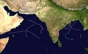 Season summary map | |
| Seasonal boundaries | |
| First system formed | April 1974 |
| Last system dissipated | November 28, 1974 |
| Seasonal statistics | |
| Depressions | 12 |
| Cyclonic storms | 7 |
| Severe cyclonic storms | 3 |
| Total fatalities | Unknown |
| Total damage | Unknown |
| Related articles | |
Systems
April 1974 Arabian Sea cyclone
This cyclone was one of the three rare April cyclone which was formed during first fifteen days of the month during the satellite era. The other cyclones were Cyclone Bijli in 2009 and Cyclone Maarutha in 2017.
May 1974 Arabian Sea cyclone

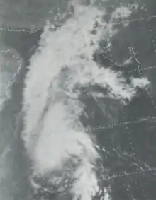
August 1974 Bay of Bengal cyclone
| Very severe cyclonic storm (IMD) | |
| Tropical storm (SSHWS) | |
 | |
| Duration | August 13 – August 20 |
|---|---|
| Peak intensity | 130 km/h (80 mph) (3-min) |
This cyclone was formed on 13 August and reached its peak intensity of Very Severe Cyclonic Storm and high end Tropical Storm equivalent by the next day. On 15 August, the storm made landfall at Digha in West Bengal. It maintained the intensity of cyclone until 17 August and dissipated on 20 August. The storm caused heavy flooding over West Bengal coastal and deltaic districts. It was a rare August cyclone to peak as a Very Severe Cyclonic Storm.
September 21–24, 1974 Arabian Sea cyclone

September 26–29, 1974 Bay of Bengal cyclone
The system developed in Bay of Bengal and lasted from September 26 until September 29.
November 23–28, 1974 Bay of Bengal cyclone
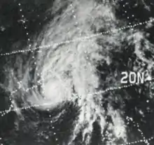
This system developed off the eastern coast of southern India on November 23 and strengthened as it moved to the northeast. The system nearly reached hurricane strength as it made landfall near Chittagong late on November 28. A 10 feet (3.0 m) storm surge accompanied the system's approach to Bangladesh, which inundated several islands offshore. Less than 100 people perished while thousands were left homeless.[3]
See also
- List of North Indian Ocean cyclone seasons
- 1974 Atlantic hurricane season
- 1974 Pacific hurricane season
- 1974 Pacific typhoon season
- Australian cyclone seasons: 1973–74, 1974–75
- South Pacific cyclone seasons: 1973–74, 1974–75
- South-West Indian Ocean cyclone seasons: 1973–74, 1974–75
References
- "Frequently Asked Questions: What is the annual frequency of Cyclones over the Indian Seas? What is its intra-annual variation?". Indian Meteorological Department. 2012. Archived from the original on May 21, 2015. Retrieved June 8, 2012.
- "Bulletins Issued by Regional Specialized Meteorological Centre (RSMC) - Tropical Cyclones, New Delhi" (PDF). India Meteorological Department. May 25, 2009. Archived from the original (PDF) on 2012-04-12. Retrieved July 16, 2012.
- Dick DeAngelis (March 1975). "Hurricane Alley". Mariners Weather Log. Vol. 19 no. 2. United States National Oceanic and Atmospheric Administration. pp. 88–89.