1976 North Indian Ocean cyclone season
The 1976 North Indian Ocean cyclone season was part of the annual cycle of tropical cyclone formation. The season has no official bounds but cyclones tend to form between April and December. These dates conventionally delimit the period of each year when most tropical cyclones form in the northern Indian Ocean. There are two main seas in the North Indian Ocean—the Bay of Bengal to the east of the Indian subcontinent and the Arabian Sea to the west of India. The official Regional Specialized Meteorological Centre in this basin is the India Meteorological Department (IMD), while the Joint Typhoon Warning Center (JTWC) releases unofficial advisories. An average of five tropical cyclones form in the North Indian Ocean every season with peaks in May and November.[1] Cyclones occurring between the meridians 45°E and 100°E are included in the season by the IMD.[2]
| 1976 North Indian Ocean cyclone season | |
|---|---|
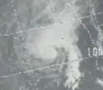
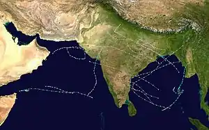 Season summary map | |
| Seasonal boundaries | |
| First system formed | April 29, 1976 |
| Last system dissipated | January 3, 1977 |
| Seasonal statistics | |
| Depressions | 14 |
| Cyclonic storms | 10 |
| Severe cyclonic storms | 7 |
| Total fatalities | Unknown |
| Total damage | Unknown |
| Related articles | |
Systems
Late April/Early May Bay of Bengal cyclone
| Tropical storm (SSHWS) | |
 | |
| Duration | April 29 – May 2 |
|---|---|
| Peak intensity | 95 km/h (60 mph) (1-min) |
June Arabian Sea cyclone
| Extremely severe cyclonic storm (IMD) | |
| Category 2 tropical cyclone (SSHWS) | |
 | |
| Duration | May 31 – June 6 |
|---|---|
| Peak intensity | 165 km/h (105 mph) (3-min) |
This system was formed on 31 May. The storm intensified till Extremely Severe Cyclonic Storm and Category 2 equivalent cyclone within next two days. On 3 June, the storm made landfall at the Saurashtra coast of Gujarat. Maximum gust winds in ocean was recorded upto 175 kmph by the ship Haakon Magnus at the day of landfall. 70 people and 4,500 cattle were perished due to the storm. 51 villages and 25,000 houses were damaged due to the storm. Total damages in Indian Rupees were estimated to be 3 crores.
September Bay of Bengal cyclone
| Very severe cyclonic storm (IMD) | |
| Tropical storm (SSHWS) | |
| | |
| Duration | September 6 – September 19 |
|---|---|
| Peak intensity | 120 km/h (75 mph) (3-min) |
This system was formed on 9 September and reached its peak intensity of Very Severe Cyclonic Storm and Tropical Storm on the next day itself. It was due to the rapid intensification. Then the storm made landfall at Contai in West Bengal on September 11. It's remnants tracked until Madhya Pradesh and dissipated on 16 September. The storm killed 40 people and 4,000 cattle. Upto 1.25 lakh hectares crops were damaged in India. Contai had gust winds as high as 155 kmph at the time of landfall. [3]
Mid-October Arabian sea cyclone
| Tropical storm (SSHWS) | |
 | |
| Duration | October 12 – October 19 |
|---|---|
| Peak intensity | 95 km/h (60 mph) (1-min) |
Mid-October Bay of Bengal cyclone
| Tropical storm (SSHWS) | |
 | |
| Duration | October 14 – October 19 |
|---|---|
| Peak intensity | 85 km/h (50 mph) (1-min) |
Early-November Bay of Bengal cyclone
| Cyclonic storm (IMD) | |
| Tropical storm (SSHWS) | |
 | |
| Duration | November 1 – November 6 |
|---|---|
| Peak intensity | 85 km/h (50 mph) (3-min) |
This system formed on 1 November and the storm made landfall at Machilipatnam in Andhra Pradesh on 4 November as a weak Cyclonic Storm. It traversed the whole landmass of peninsular India and entered into the Arabian Sea on 6 November off the coast of Maharashtra. But the storm dissipated without any significant intensification by the same day. 25 people were reported to be killed by the storm and 13 fishermen remain missing. 25,000 huts were damaged by the storm. It tracked very close to Hyderabad during its movement but minimal damages were reported in the city.
Mid-November Bay of Bengal cyclone
| Severe cyclonic storm (IMD) | |
| Tropical storm (SSHWS) | |
| | |
| Duration | November 15 – November 17 |
|---|---|
| Peak intensity | 110 km/h (70 mph) (3-min) |
This cyclone was formed on 15 November off South Andhra coast. Due to its close proximity to the land, the storm was unable to intensify further. As a weak cyclone, it made landfall between Nellore and Kavali in Andhra Pradesh on 16th midnight and dissipated by the next day over Rayalaseema. 30 people were killed due to the storm. 10,000 houses and 25 boats were damaged due to the storm surge and gust winds. Damages in Indian Rupees were estimated to be 3.9 crores. Nellore District was the worst affected due to the cyclone.
But an analysis regarding this cyclone suggested unofficially that this cyclone peaked as a Super Cyclonic Storm despite being close proximity to the land with windspeed of 220 kmph. But it proved to be false.
Late-December Bay of Bengal cyclone
| Category 1 tropical cyclone (SSHWS) | |
 | |
| Duration | December 27 – January 3 |
|---|---|
| Peak intensity | 120 km/h (75 mph) (1-min) |
See also
- List of North Indian Ocean cyclone seasons
- 1976 Atlantic hurricane season
- 1976 Pacific hurricane season
- 1976 Pacific typhoon season
- Australian cyclone seasons: 1975–76, 1976–77
- South Pacific cyclone seasons: 1975–76, 1976–77
- South-West Indian Ocean cyclone seasons: 1975–76, 1976–77
References
- "Frequently Asked Questions: What is the annual frequency of Cyclones over the Indian Seas? What is its intra-annual variation?". Indian Meteorological Department. 2012. Archived from the original on May 21, 2015. Retrieved June 8, 2012.
- "Bulletins Issued by Regional Specialized Meteorological Centre (RSMC) - Tropical Cyclones, New Delhi" (PDF). India Meteorological Department. May 25, 2009. Archived from the original (PDF) on 2012-04-12. Retrieved July 16, 2012.
- Dipankar C. Patnaik & N. Sivagnanam (November 2007). "DISASTER VULNERABILITY OF COASTAL STATES: A Short Case Study of Orissa, India". Social Science Research Network. p. 4. SSRN 1074845. Missing or empty
|url=(help)