Aïn Yagout
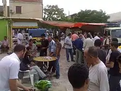
Aïn Yaqout (Arabic: عين ياقوت · chaoui: ⵜⴰⴳⵓⵜ) is an Algerian community in Villa Batna, 35 km northeast of Batna and 75 km southwest of Constantine.
Aïn Yagout | |
|---|---|
 | |
| Nickname(s): The City of Fog, Yagout | |
 | |
 Aïn Yagout | |
| Coordinates: 35°47′N 6°25′E | |
| Country | Algeria |
| Province | Batna |
| Government | |
| Time zone | UTC+1 (West Africa Time) |
| Website | ain-yagout.fr.gd |
Location
The territory of Aïn Yagout is located to the northeast of the wilaya of Batna.
Towns of the municipality
The communities of Aïn Yagout are made up of 10 localities:
- Thagout
- Dahr Azem
- El Malha
- Tehawit
- Ayath Mloule
- Bir Ammar
- Draa Boultif
- Gabel
- Mechta Chorfa
- Theniet Saïda
History
The city of Aïn Yagout was a village located around a fountain (source of water from which the name was derived) composed essentially of [Who?]. Previously he was called Douar Sidi Ali.
In 1873, the French army decided to make it a place of cantonment. After a massive exodus of residents from neighboring villages to these places, the French decided to erect a gendarmerie barracks near the fountain
Aïn Yagout had the status of commune on January 12, 1957.
Toponymie
The name of the town ain yagout is an arabized toponym formed by two components: عين Aïn meaning "source" and the suffix ياقوت Yakout (or Yagout) meaning "ruby" or "hyacinth" but the origin of the appellation is Tamazight Berber Thagouth ⵜⴰⴳⵓⵜ meaning "fog"
Demography
Demographic evolution
| 1966 | 1977 | 1984 | 1998 | 2008 |
|---|---|---|---|---|
| 4 358 | 5 220 | 7 000 | 8 988 | 10 856 |
Festivals
- Yennayer or Yennar (Amazigh New Year).
- Thafsouth (The beginning of spring).
.svg.png.webp)
