Arris, Batna
Arris (Arabic: آريس; Berber languages: ⴰⵔⵔⵉⵙ) is a commune in the Batna wilaya in eastern Algeria.
Arris
Arabic: آريس ⴰBerber: ⵔⵔⵉⵙ | |
|---|---|
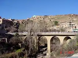 View of one of the bridges in the city of Arris | |
 Location of Arris within Batna wilaya | |
 Arris Location of Arris within Algeria | |
| Coordinates: 35°15′N 6°21′E | |
| Country | Algeria |
| Wilaya | Batna |
| Daïra | Arris |
| Area | |
| • Total | 152 km2 (59 sq mi) |
| Highest elevation | 1,100 m (3,600 ft) |
| Lowest elevation | 900 m (3,000 ft) |
| Population (2011) | |
| • Total | 32,597 |
| • Density | 214/km2 (550/sq mi) |
| Time zone | UTC+1 (West Africa Time) |
| Climate | BSk |
Geography
Location
The Arris commune's jurisdiction is located in the Southwest of the Batna wilaya.
Neighboring Communes of Arris | ||||||||||
|---|---|---|---|---|---|---|---|---|---|---|
| ||||||||||

Arris Localities
The Arris commune is made up of 15 neighborhoods:[1]
- Afra
- Anza Ahmed
- Aourdaddam
- Arris
- Bouyeghiel
- Dechera El Hamra
- Khenguet Zerouala
- Khenguet Zidane
- Laraddam
- Merj Hamed
- Ras Draa
- T'Zaouket
- Tamayoult
- Tibhirine
Physical Geography
The city of Arris is located at an altitude of 1100 m in the highlands of Oued El Abiod, between the Djebel[2] Zellatou to the east, Djebel Ichmoul to the north (Aïn Tinn pass at 1800 m[3]), and Djebel El Azreg to the west.
Human Geography
Arris is connected to Biskra and Batna by Route Nationale 31, which passes through the Aïn Tinn pass; a secondary route connects Arris to Baâli (Teniet El Abed) in the valley of Oued Abdi.
Toponymy
Arris means "white lands" or "lion cub" in the Chaoui Berber language spoken in the Aurès Mountains.
History
Antiquity
The city is very ancient. Arris was the capital of the Gaetuli (Zenata) Berbers who rose up against Rome.[4] At the time, historians called them Moors. They were a people who had lived in the region for a long time.[5]
After the fall of the Roman empire, Masties became an independent ruler of the Kingdom of the Aures. In an inscription discovered in Arris, dating to the end of the 5th century to the mid-6th century, he proclaims his Christian faith and the title of Imperator during his rule until 516 AD.[6][7]
Middle Ages
The arrival of the Vandals in the region has been confirmed by historians, but Masties escaped their conquest and a monument erected pays homage to the Masties's memory, "inflexibly loyal to the Roman ideal and to the forms of imperial government," according to Jérôme Carcopino.[8]
Among the other princes and leaders in the Aurès, Tacfarinas was a rebel leader. Cutzinas was a rebel leader; he had a Roman mother according to Corippus.[9] The two historical figures in the Aurès region at the beginning of the Muslim Conquest of North Africa were Kusaila of the Awraba tribe[fr] and Dihya, queen of the Jarawa tribe, known as al-Kāhina.
French Colonization
On December 18, 1886,[10] the mixed commune (commune mixte[fr] - an area where Europeans were present though in very small numbers) of Aurès was created in the Batna arrondissement (district) of the Constantine département of French Algeria, with its capital in Arris.[11]
Arris was therefore the residence of the chief administrator, assisted by two assistants, a secretary, and other employees (for example, messengers). This mixed commune was divided into douars, each under the responsibility of a "native assistant" ("adjoint indigène") - "qaid" from 1919 on. In 1936, the mixed commune comprised fourteen douars and a "center of colonization" (Foum Toub).
The ethnologists Thérèse Rivière[fr] and Germaine Tillion, who spent much time in the Aurès region from 1934 to 1940, make reference to Arris in the 1930s in their articles and reports regarding the Aurès:[12] Connected to Batna by a route with a regular bus line, the city contained a clinic and a primary school, but no business. It was connected to Biskra by motorway.[13] The police force of Arris was six men strong for a population of 60,000 inhabitants of the Aurès region.
The Algerian War
One of the nine founders of the National Liberation Front (FLN) in October 1954, Mostefa Ben Boulaïd was born to a notable family in Arris. Militant in the Algerian People's Party (PPA), then in the Movement for the Triumph of Democratic Liberties (MTLD), he was in charge of the Aurès zone from October 1954 until his death in March 1956; his immediate successor was his brother, Omar Ben Boulaïd.
On November 1, 1954, the day of the Toussaint Rouge, the insurgents managed to isolate Arris for several hours.
On June 28, 1956, during the French government's administrative reorganization of Algeria, Batna became a prefecture and Arris a sub-prefecture; several douars became communes: Bouzina, Chir, Kimmel, M'chouneche, Menaa, Oulach, Tadjmout et Tighanimine.[14]
Independence
The communes of Arris and Tighanimine form the daïra of Arris, one of 21 daïras in the wilaya of Batna.
Demographics
Evolution of the Population since 1966
| 1966 | 1977 | 1984 | 1998 | 2008 |
|---|---|---|---|---|
| 10,699 | 14,996 | 18,000 | 24,607 | 30,207 |
Daily Life
Sports
Every year, the Chahid Mostefa Ben Boulaïd half-marathon takes place in the city.
Notable people
- Mostefa Ben Boulaïd (1917-1956), one of the founders of the FLN (Front de libération nationale), was born in Arris.
References
- Journal officiel de la République Algérienne, 19 décembre 1984. Décret n° 84-365, fixant la composition, la consistance et les limites territoriale des communes. Wilaya de Batna, p. 1479.
- Djebel is a French term borrowed from Arabic which means a mountain or a mountainous region."Djebel". Wikipédia.
- "col de Ain Tinne 1805 m-Route Arris Batna". vitaminedz.com (in French). Retrieved 2020-05-05.
- Société archéologique de la province de Constantine (1874). Recueil des notices et mémoires de la Société archélologique de la province de Constantine, Volume 16 (in French). Alessi et Arnolet. p. 131.
gétule aurès.
- Anne-Marie Flambard Hérich, Les Lieux de pouvoir au Moyen Âge en Normandie et sur ses marges.
- Rousseau, Philip (2012). A Companion to Late Antiquity. John Wiley & Sons. ISBN 978-1-405-11980-1.
- Jérôme Carcopino et Louis Leschi, « Inscription d'Arris (Aurès) en l'honneur de Masties », Comptes-rendus des séances de l'Académie des Inscriptions et Belles-Lettres, 88e année, n° 1, 1944, pp. 13-14, available online in French on Persée.
- « inflexiblement fidèle à l'idée romaine et aux formes du gouvernement impérial » Ibid, « Inscription d'Arris... »
- Cf. M1 Identité et ethnicité: concepts ... et Anne-Marie Flambard Hérich, Les Lieux de pouvoir ....
- Cf. Fonds Arris (ANOM)
- "Sous-préfectures d'Algérie. Commune mixte puis sous-préfecture d'Arris (1867/1961)" (in French).
- Il était une fois l'ethnographie et L'Algérie aurésienne.
- « L'Aurès en 1934 », carte, dans L'Algérie aurésienne, p. 5
- Cf. Fonds Arris (ANOM).
- Philippe Thiriez, chap. 3 (« Batna »), p. 47
.svg.png.webp)