A77 road
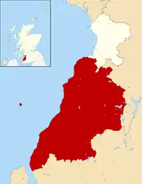
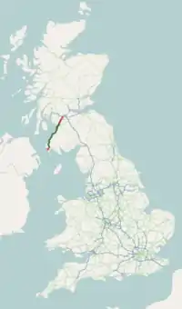
The A77 road is a major road in Scotland. It runs in a southwesterly direction from the city of Glasgow, past the towns of Giffnock, Newton Mearns, Kilmarnock, Prestwick, Ayr, Maybole, Girvan and Stranraer to the village of Portpatrick on the Irish Sea. It passes through the council areas of Glasgow City, East Renfrewshire, East Ayrshire, South Ayrshire and Dumfries and Galloway.
| |
|---|---|
 | |
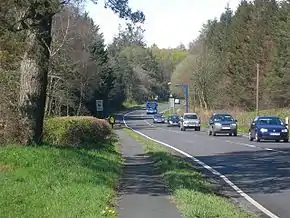 On The A77 near Minishant, showing SPECS camera | |
| Route information | |
| Length | 91.7 mi[1] (147.6 km) |
| Major junctions | |
| Northeast end | Glasgow 55.8563°N 4.2576°W |
J5-8 → M77 motorway | |
| Southwest end | Portpatrick 54.8418°N 5.1168°W |
| Location | |
| Primary destinations | Glasgow, Kilmarnock, Prestwick Airport, Ayr, Stranraer |
| Road network | |

It has full trunk road status from the terminus of the M77 motorway at Fenwick to the junction with the A75 in Stranraer.
The A77 is an important link from Glasgow to one of its two major airports, Prestwick Airport, and to the two Northern Ireland ferry terminals at Cairnryan. As a result, the road is subject to a busy mixture of commuter, tourist and heavy goods vehicle traffic which has necessitated upgrades to many sections.
History
Bypasses for Ayr and Kilmarnock were built in the 1970s, and the M77 motorway replaced the Glasgow to Newton Mearns section in two stages, in the mid-to-late 1990s, but not without controversy as a section of the motorway was routed through Pollok Country Park.
This still left the East Ayrshire stretch of the road which widely appeared in statistics as one of the most dangerous sections of road in Scotland. The majority of this section was an unsegregated, 4-lane single carriageway between Kilmarnock and Newton Mearns and the lanes were narrow compared to the standard of other major roads. At several points, it was common for traffic waiting to turn right to queue in the overtaking lane. The speed limit of 60 miles per hour (97 km/h) was widely ignored. Finally, the road narrowed to only two lanes near Newton Mearns, causing long queues. The combined result was a number of fatal crashes. The Scottish Executive took the decision to replace the entire section up to the Kilmarnock bypass with an extension of the M77 after pressure and campaigning from West Sound and West FM.
Construction of the motorway was faster than usual, given the eagerness to replace the A77 after another fatal crash in June 2002 resulted in the death of Hugh Davidson, then Chief Inspector of Strathclyde Police,[2] and the motorway was opened in April 2005. This completed a continuous dual carriageway road from Glasgow to Ayr.
In an effort to prevent a repeat of the fatalities on the southern section of the road, July 2005 saw the A77 become host to the largest automatic speed limit enforcement system in the whole of the UK. Based on the digital SPECS system rather than the traditional fixed post GATSO film cameras, gantries with automatic numberplate recognition cameras are sited on the road at intervals of between 1 and 5 miles (2 and 8 km) and measure the average speed of traffic. The enforced zone stretches from the Bogend Toll Junction (Dundonald/Tarbolton junction) at its northern end on the dual carriageway section, down to just north of Lendalfoot; a distance of around 32 miles (51 km).[3]
From 10 March 2008 a long term temporary 50 mph (80 km/h) limit from Bogend Toll to Dutch House Roundabout was introduced,[4] following the death in October 2006 of another police officer, Constable Kevin Lowe. Constable Lowe was on duty and en route at approximately 120 mph (190 km/h) in an unmarked car to a call at the time.[5] This speed limit was to remain in force until new grade separated junctions were opened in 2014.[6] It's still in force.
There have been continued efforts to improve the road in the south. One such project, the Turnberry Climbing Lane which opened in 2005, has enhanced guaranteed overtaking opportunities on the single carriageway section. Another improvement opened in Autumn 2006, the upgraded Whitletts roundabout[7] with traffic lights and spiral lanes. Climbing lanes were added at Haggstone and Drummuckloch and a 0.8-mile (1.3 km) stretch was straightened north of nearby Glenapp in autumn 2008.[8] In 2011 a 1.8-mile (2.9 km) stretch was widened from Park End to Bennane.[9]
The A77 was formerly part of the Euroroute system, and comprised route E111.
Proposed developments
A bypass for Maybole is being built and a contract was awarded in April 2019.[10]
Further minor improvements are planned with no dates published for:[11]
Ardwell to Slockenray overtaking lane 1.2 miles (1.9 km)
Dowhill to Chapeldonan realignment 2.0 miles (3.2 km)
References
- "Driving directions to Main St/A77". Google. Retrieved 23 September 2013.
- "Police Roll of Honour 2002". Roll of Honour Research. 29 May 2012. Retrieved 31 December 2012.
- "A77 Symington and Bogend Toll Project – Project Benefits". Transport Scotland. November 2010. Archived from the original on 12 October 2013. Retrieved 1 January 2013.
- "SPECS CONTINUES TO REDUCE A77 CASUALTIES". A77 Safety Group. 30 October 2008. Retrieved 1 January 2013.
- "DETERMINATION IN RESPECT OF THE DEATH OF POLICE CONSTABLE KEVIN LOWE". Scotcourts.gov.uk. 12 November 2007. Retrieved 31 December 2012.
- "Transport Scotland invites bids for A75 and A77". Construction Enquirer. 12 April 2012. Retrieved 1 January 2013.
- "IMPROVEMENTS AT WHITLETTS". A77 Safety Group. 2006. Archived from the original on 9 February 2012. Retrieved 1 January 2013.
- "South west Scotland gets roads improvements Christmas present". A77 Safety Group. December 2008.
- "Transport Minister views progress of A77". Transport Scotland. 13 July 2011. Archived from the original on 14 April 2015. Retrieved 1 January 2013.
- "Jobs boost thanks to A77 contract award". Transport Scotland. 18 April 2019. Retrieved 24 April 2019.
- "Trunk Road Projects". Transport Scotland. November 2010. Archived from the original on 8 December 2013. Retrieved 1 January 2013.
External links
A roads in Zone 7 of the Great Britain road numbering scheme | ||
|---|---|---|