Abbey Road, London
Abbey Road is a thoroughfare in the borough of Camden and the City of Westminster in London, running roughly northwest to southeast through St. John's Wood, near Lord's Cricket Ground. It is part of the road B507. This road is best known for the Abbey Road Studios and for featuring on the cover of The Beatles’ album of the same name, which was released in September 1969.
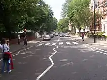 The crossing in January 2003 | |
| Length | 0.9 mi[1] (1.4 km) |
|---|---|
| Location | St. John's Wood, London |
| Postal code | NW8 |
| Nearest Tube station | |
| Coordinates | 51.532006°N 0.177331°W |
| South end | Quex Road, Kilburn |
| East end | Grove End Road St. John’s Wood |
| Other | |
| Known for | |
Location
The north western end of Abbey Road begins in Kilburn, at the junction with Quex Road and West End Lane. The road was once a track leading to Kilburn Priory, and its associated Abbey Farm, and was developed in the beginning of the nineteenth century.[2] It continues south east for roughly a mile, crossing Belsize Road, Boundary Road, and Marlborough Place, ending at the junction of Grove End Road and Garden Road.
History
The Abbey National Building Society (now Santander UK) was founded in 1874 as, The Abbey Road & St John’s Wood Permanent Benefit Building Society, in one Baptist Church, on Abbey Road.
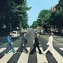
EMI's Abbey Road Studios is located at the south eastern end, at 3 Abbey Road, St John's Wood. The Beatles, Brockhampton, and many other famous popular music performers, have recorded at this studio, and the Beatles named their last studio LP after this street. The album's cover photograph, shows the four group members walking across the zebra crossing, just outside the studio entrance.
As a result of its association with the Beatles, since 1969, this part of Abbey Road has been featured on the London tourism circuit. The crossing was given status of Grade II Listed Building, by English Heritage, in December 2010.[3] The zebra crossing, featured on the Beatles cover, has become a popular photo opportunity area, despite the road still being the busy thoroughfare for traffic.
There have been stories about the zebra crossing, having been shifted from its original location, but these are ungrounded myths, based on the storm water drain, located on the north eastern corner of the crossing, which has been there since the establishment of the sewer system, in the City of Westminster.
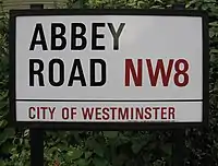
The album cover of the Beatles has been parodied many times over the years. The street sign, on the corner of Grove End Road and Abbey Road, is now mounted high, on the building on the corner, to save the local council the expense of cleaning and replacing the sign, which was frequently defaced, or stolen. The council repaints the wall next to the zebra crossing every three months, to cover fans’ occasional graffiti.[4]
Abbey Road is also one ward of the City of Westminster. At the census of 2011, this ward had a population of 11,250.[5]
References
- Google (30 October 2015). "Abbey Road, London" (Map). Google Maps. Google. Retrieved 30 October 2015.
- Mills, A.D. (2010). A Dictionary of London Place-Names. Oxford University Press. p. 1. ISBN 9780199566785.
- "Beatles' Abbey Road zebra crossing given listed status". BBC Online. 22 December 2010. Archived from the original on 30 December 2010. Retrieved 29 December 2010.
- Pollard, Lawrence (7 August 2009). "Revisiting Abbey Road 40 Years On". BBC Online. Retrieved 2 November 2010.
- "City of Westminster Ward population 2011". Neighbourhood Statistics. Office for National Statistics. March 2011. Retrieved 16 October 2016.
External links
| Wikimedia Commons has media related to Abbey Road. |
- Abbey Road London, QuickTime VR
- Abbey Road webcam
- Satellite View of Crosswalk / Zebra Crossing
- Google Street View of Crosswalk / Zebra crossing
| History | |
|---|---|
| Tours and performances | |
| Associated people | |
| Associated companies | |
| Associated places |
|
| Lists | |
| Books | |
| Related articles | |
| |
| Authority control |
|---|