Acadia, Calgary
Acadia is a neighbourhood in the southeast quadrant of Calgary, Alberta. The area is bounded on the west by Macleod Trail, on the east by the Bow River, on the north by Heritage Drive and on the south by Southland Drive.
Acadia | |
|---|---|
Neighbourhood | |
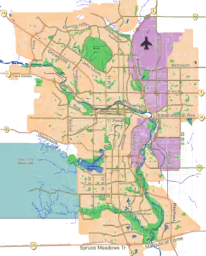 Acadia Location of Acadia in Calgary | |
| Coordinates: 50°58′02″N 114°03′33″W | |
| Country | |
| Province | |
| City | |
| Quadrant | SE |
| Ward | 9 |
| Established | 1960 |
| Annexed | 1956 |
| Government | |
| • Mayor | Naheed Nenshi |
| • Administrative body | Calgary City Council |
| • Councillor | Gian-Carlo Carra |
| Elevation | 1,050 m (3,440 ft) |
| Population (2011)[2] | |
| • Total | 10,615 |
| Website | Acadia Community Association |
The land was annexed to the City of Calgary in 1956, and Acadia was established in 1960.
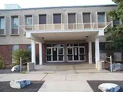
The neighbourhood's main street is Fairmount Drive, and many of the area's businesses cluster along the street. The area also contains Lord Beaverbrook High School, the city's largest high school.
Demographics
In the City of Calgary's 2012 municipal census, Acadia had a population of 10,705 living in 5,053 dwellings, a 0.8% increase from its 2011 population of 10,615.[2] With a land area of 3.9 km2 (1.5 sq mi), it had a population density of 2,740/km2 (7,110/sq mi) in 2012.[2][3]
Residents in this community had a median household income of $46,089 in 2000, and there were 19.2% low income residents living in the neighbourhood. As of 2000, 19.4% of the residents were immigrants. A proportion of 38.8% of the buildings were condominiums or apartments, and 38.9% were used for renting.[4]
Education
The following schools are located in Acadia:
- Public schools:
- Acadia Elementary
- Alice M. Curtis Elementary - Public
- Andrew Davison Bilingual Elementary - Public
- David Thompson Junior High - Public
- Ecole de la Source - Francophone
- Fred Parker Elementary
- Lord Beaverbrook Senior High
- Foundations for the Future
- Catholic schools:
- Ecole St. Cecilia Bilingual Elementary
- Ecole St. Matthew Elementary & Junior High
Transit
Acadia is served by Calgary Transit Bus Route 99. The Heritage CTrain Station serves Acadia. Route 10 serves north and south via Fairmont Dr.
See also
References
- "Calgary Elections". City of Calgary. 2017. Retrieved November 12, 2017.
- "2012 Civic Census Results" (PDF). City of Calgary. 2012. Retrieved February 4, 2013.
- "Community Boundaries" (Esri shapefile). City of Calgary. Retrieved February 5, 2013.
- City of Calgary (2006). "Acadia Community Statistics" (PDF). Archived from the original (PDF) on 2007-09-27. Retrieved 2007-05-08.
External links
Places adjacent to Acadia, Calgary | ||||||||||
|---|---|---|---|---|---|---|---|---|---|---|
| ||||||||||