Agriculture in Djibouti
Agriculture is the third economic activity in Djibouti which makes up only 3 percent of the wider economy value. Djibouti depends on imports in most foods.[1] Climatic conditions and poor soils limit farm output, and domestic food production meets about 15% of demand. 10% of the Djiboutian workforce are employed in agriculture.
History of agricultural development
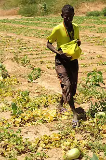
In the year 1999, the amount of vegetation that was produced in Djibouti was about 23,000 tons.[2] Agriculture consists of growing of tomatoes in the country that is usually for the purpose of household utilization and the date palms are also produced along the coastal fringes of the country.
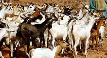
Djibouti's harsh climate does not support much variety in the flora. The production in the area of agriculture is limited to a certain extent. In Djibouti the official figure that was given in 1991 for employment in agriculture was about 75 percent of the total employment. In Djibouti, farm animals have always received greater importance in comparison to farming and agriculture, which consists of vegetables and fruits. The agricultural products of Djibouti include goats, animal hides, camels and sheep.
Land use and irrigation
Which 10 km2 dedicated to irrigated agriculture, under 2% of the land is arable and about 60% is suitable for grazing livestock. Most arable land is in the Tadjourah region, and the Mabla Mountains near Obock.[3] The highest parts of Goda Mountains receive 300–500 mm of rain annually, and the adjacent area, north of the Mabla Mountains, receives 200–300 mm. Central and Southern Boura Mountains and Arta Mountains average 150 to 250 mm.
Fishing
Djibouti has a coastline of 372 km of and a maritime area of 6280 km2 at the crossroads of the Red Sea and Gulf of Aden.[4] Djibouti's fishing catch was 503 tons by 1981. Most fleets were located on the eastern coast near Djibouti City.
Statistics
Geographic coordinates:
Area: 22,000 km2
Land: 21,980 km2
Water: 20 km2
Coastline: 314 km
Contiguous zone: 24 nm
Exclusive economic zone: 200 nm
Territorial sea: 12 nm
Climate: Desert, dry
Terrain: Coastal plain and plateau separated by central mountains
Natural resources: potential geothermal power, gold, clay, granite, limestone, marble, salt, diatomite, gypsum, pumice, petroleum
Land use:
Arable land: 2%
Permanent crops: 0%
Permanent pastures: 73%
Forests and woodland: 2%
Other: 26% (2016 est.)
Irrigated land: 10 km2
Natural hazards: earthquakes, droughts, occasional cyclonic disturbances from the Indian Ocean which bring heavy rains and flash floods
Notes
- Akadar Abdoulkader, Bori; Mohamed, Bourioug; Nabil, Mohamed; Alaoui-Sossé, Badr; Eric, Cavalli; Aleya, Lotfi (2015). "Wastewater use in agriculture in Djibouti: Effectiveness of sand filtration treatments and impact of wastewater irrigation on growth and yield of Panicum maximum". Ecological Engineering. 84: 607–614. doi:10.1016/j.ecoleng.2015.09.065.
- "Plans to develop Djibouti's agriculture and fishing to promote food and employment security". 2016-03-16.
- "Faster growing crops could improve food production". 2004-07-07.
- "FAO Fishery Country Profile - DJIBOUTI".
External links
| Wikimedia Commons has media related to Agriculture in Djibouti. |
| History |  | ||
|---|---|---|---|
| Geography | |||
| Politics |
| ||
| Economy | |||
| Culture | |||
Currency: Djiboutian franc | |
| Communications |
|
| Industries: | |