Aguarico Canton
Aguarico Canton is a canton of Ecuador, located in the Orellana Province. Its capital is the town of Nuevo Rocafuerte. Its population at the 2010 census was 4,658 INEC 2010.[2][3]
Aguarico Canton | |
|---|---|
 Flag | |
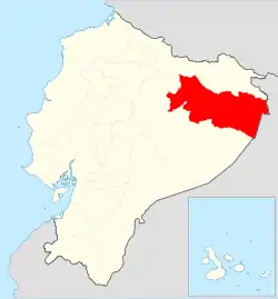 Location of Orellana Province in Ecuador. | |
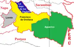 Cantons of Orellana Province | |
| Coordinates: 0°55′16″S 75°23′57″W | |
| Country | |
| Province | Orellana Province |
| Capital | Nuevo Rocafuerte[1] |
| Area | |
| • Total | 4,385.2 sq mi (11,357.7 km2) |
| Population (2001) | |
| • Total | 4,658 |
| Time zone | UTC-5 (ECT) |
Aguarico is part of the Cuyabeno Natural Reserve and Yasuni National Park.
History
Aguarico dates from the late nineteenth century during an estate boom on the banks of the Napo River in the Amazon region. During the invasion of Peru in Ecuador in 1941, Rocafuerte was taken by the Peruvian army after defeating the Ecuadorian military garrison on 11 August of that year. Following the armed conflict, almost all rubber plantations were abandoned.
On 22 February 1945, by order of President Jose Maria Velasco Ibarra, the town of Nuevo Rocafuerte officially became the new county seat of the Canton of Aguarico.
Parishes
- Nuevo Rocafuerte
- Cononaco
- Tiputini
- Yasuní
- Santa María Huiririma
- Capitán Augusto Rivadeneira.
Demographics
Ethnic groups as of the Ecuadorian census of 2010:[4]
- Indigenous 77.4%
- Mestizo 20.1%
- Afro-Ecuadorian 1.4%
- White 0.8%
- Montubio 0.1%
- Other 0.1%
Places of interest
References
- http://mapasamerica.dices.net/ecuador/mapa.php?nombre=Canton-Aguarico&id=15107. Missing or empty
|title=(help) - "Ecuador - VII Censo de Población y VI de Vivienda 2010 - Información general". anda.inec.gob.ec. Archived from the original on 2017-11-17. Retrieved 2017-11-08.
- Cantons of Ecuador at statoids.com
- Censos, Instituto Nacional de Estadística y. "Resultados -". www.ecuadorencifras.gob.ec.