Ahunui
Ahunui or Nga-taumanga[2] is a small atoll of the eastern Tuamotu Archipelago in French Polynesia. It is located 55 km SSE of Paraoa Atoll and 120 km WSW of Vairaatea.[3]
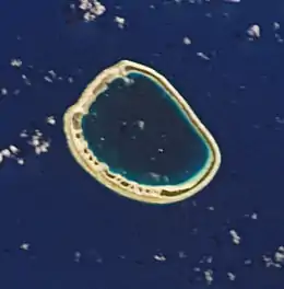 NASA picture of Ahunui Atoll | |
 Ahunui | |
| Geography | |
|---|---|
| Location | Pacific Ocean |
| Coordinates | 19°37′S 140°23′W |
| Archipelago | Tuamotus |
| Area | 34 km2 (13 sq mi) (lagoon) 5.4 km2 (2 sq mi) (above water) |
| Width | 6.5 km (4.04 mi) |
| Administration | |
France | |
| Overseas collectivity | French Polynesia |
| Administrative subdivision | Tuamotus |
| Commune | Hao |
| Demographics | |
| Population | Uninhabited[1] (2012) |
Ahunui Atoll is roughly circular in shape and measures 6.5 km in diameter.[3] It has a land area of approximately 5.4 km2 and a lagoon area of 34 km2. Its lagoon is totally encircled by the reef, so that it is not connected to the ocean by a pass. The islands have coconut plantations on them.
Ahunui Atoll is permanently uninhabited, but it is visited occasionally by neighboring islanders. The rarer pipi oysters (Pinctada maculata) are found in its lagoon.[4]
History
The first recorded European who arrived to Ahunui Atoll was British mariner Frederick William Beechey. He named it "Byam Martin" after Admiral of the Fleet Sir Thomas Byam Martin.
Administration
Ahunui belongs to the commune of Hao (Main village: Otepa), which includes Ahunui (uninhabited), Nengonengo, Manuhangi (uninhabited) and Paraoa (uninhabited).[5]
See also
- Desert island
- List of islands
References
- "Population". Institut de la statistique de la Polynésie française. Retrieved 23 September 2014.
- Young, J.L. (1899). "Names of the Paumotu Islands, with the old names so far as they are known". Journal of the Polynesian Society. 8 (4): 264–268. Retrieved 7 January 2015.
- "Ahunui". oceandots.com. Archived from the original on December 23, 2010. Retrieved 2008-03-03.
- de:Ahunui
- fr:Hao
External links
Tuamotus Gambiers | Islands/Atolls | ||
|---|---|---|---|
| Island groups | |||
| Authority control |
|
|---|