Fangatau
Fangatau, or Nakai-erua,[2] is a small atoll in the Tuamotu group in French Polynesia. The nearest land is Fakahina Atoll, located 72 km to the ESE. This small atoll has an elongated shape. Its length is 8 kilometres (5.0 miles), maximum width 3.5 kilometres (2.2 miles). It has a total area of 22.2 square kilometres (8.6 square miles),[3] land area 5.9 km2. Its reef encloses its lagoon completely. Anchorage is difficult. Fangatau Atoll has 135 inhabitants (2017 census).[4] Teana is the main village.
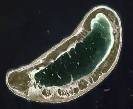 NASA picture of Fangatau Atoll | |
 Fangatau | |
| Geography | |
|---|---|
| Location | Pacific Ocean |
| Coordinates | 15°49′12″S 140°53′14″W |
| Archipelago | Tuamotus |
| Area | 22.2 km2 (8.6 sq mi) (lagoon) 9.4 km2 (4 sq mi) (above water) |
| Length | 8 km (5 mi) |
| Width | 3.5 km (2.17 mi) |
| Administration | |
France | |
| Overseas collectivity | French Polynesia |
| Administrative subdivision | Îles Tuamotu-Gambier |
| Commune | Fangatau |
| Largest settlement | Teana |
| Demographics | |
| Population | 135[1] (2017) |
| Pop. density | 24/km2 (62/sq mi) |
Fangatau | |
|---|---|
 | |
 | |
Location of Fangatau 
| |
| Coordinates: 15°49′12″S 140°53′14″W | |
| Country | France |
| Overseas collectivity | French Polynesia |
| Subdivision | Îles Tuamotu-Gambier |
| Area 1 | 14.3 km2 (5.5 sq mi) |
| Population (2017) | 296 |
| • Density | 21/km2 (54/sq mi) |
| Time zone | UTC−10:00 |
| INSEE/Postal code | 98717 / |
| 1 French Land Register data, which excludes lakes, ponds, glaciers > 1 km2 (0.386 sq mi or 247 acres) and river estuaries. | |
History
The first recorded European to arrive at Fangatau was Russian explorer Fabian Gottlieb von Bellingshausen on the 10 July 1820 on ships Vostok and Mirni. He named this atoll "Arakcheev". Fangatau was the home of Kamake an Iturangi, regarded by anthropologist Kenneth Emory as "the greatest Tuamotuan sage" he ever met.[5]
Administration
The commune of Fangatau consists of Fangatau Atoll, as well as the atoll and associated commune of Fakahina.[6] The seat of the commune is the village Teana.[6]
| Atoll | Main village | Population 2017[4] | Land area (km²)[7] | Lagoon (km²) | Coordinates |
|---|---|---|---|---|---|
| Fangatau | Teana | 135 | 5.9 | 11 | 15°49′S 140°52′W |
| Fakahina | Tarione | 161 | 8.3 | 20 | 15°59′S 140°08′W |
| Commune of Fangatau | Teana | 296 | 14.3 | 31 |
| Atoll | Main village | Population 2007 | Population 2012 | Population 2017 |
|---|---|---|---|---|
| Fangatau | Teana | 121 | 145 | 135 |
| Fakahina | Tarione | 131 | 155 | 161 |
| Commune of Fangatau | Teana | 252 | 300 | 296 |
Transport
The atoll is served by the Fangatau Airport (IATA: FGU, ICAO: NTGB).
See also
References
- "Population". Institut de la statistique de la Polynésie française. Retrieved 25 September 2014.
- Young, J.L. (1899). "Names of the Paumotu Islands, with the old names so far as they are known". Journal of the Polynesian Society. 8 (4): 264–268. Retrieved 7 January 2015.
- ICES Journal of Marine Science
- Répartition de la population en Polynésie française en 2017, Institut de la statistique de la Polynésie française
- Emory, Kenneth P. (1940). "Tuamotuan concepts of creation". Journal of the Polynesian Society. 49 (193): 117. Retrieved 8 May 2015.
- Décret n°72-407 du 17 mai 1972 portant création de communes dans le territoire de la Polynésie française, Légifrance
- "R1- Population sans doubles comptes, des subdivisions, communes et communes associées de Polynésie française, de 1971 à 1996". Institut de la statistique de la Polynésie française. Retrieved 2019-03-14.
External links
| Wikimedia Commons has media related to Fangatau Atoll. |
Tuamotus Gambiers | Islands/Atolls | ||
|---|---|---|---|
| Island groups | |||