Alaskan Way
Alaskan Way, originally Railroad Avenue, is a street in Seattle, Washington, that runs along the Elliott Bay waterfront from just north of S. Holgate Street in the Industrial District—south of which it becomes East Marginal Way S.— to Broad Street in Belltown, north of which is Myrtle Edwards Park and the Olympic Sculpture Park. The right-of-way continues northwest through the park, just west of the BNSF Railway mainline, and the roadway picks up again for a few blocks at Smith Cove.[2][3][4] It follows a route known in the late 19th century as the "Ram's Horn" because of its shape.[5] The street gave its name to the Alaskan Way Viaduct, which until 2019 carried Washington State Route 99 through Downtown Seattle.
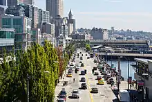 Alaskan Way as seen from Bell Street in 2011, with the Alaskan Way Viaduct in the background | |
| Former name(s) | Railroad Avenue |
|---|---|
| Namesake | Alaska |
| Maintained by | Seattle Department of Transportation |
| Length | 1.5 mi[1] (2.4 km) |
| Location | Seattle, Washington, U.S. |
| South end | South King Street |
| Major junctions | |
| North end | Broad Street |
History

The idea of building a rail corridor along Seattle's Central Waterfront goes back at least to Thomas Burke and Daniel Hunt Gilman and the construction of the Seattle, Lake Shore and Eastern Railway in the years before the Great Seattle Fire of 1889.[6] Railroad Avenue was built as a planked roadway on pilings over the waters of Elliott Bay.[3][5] South of Downtown, the rail line constituted the one major man-made feature in an area of tideflats.[7]
The portion of Railroad Avenue from Yesler Way in what is now the Pioneer Square neighborhood to University Street near today's Harbor Steps burned in the Great Fire, as did most of the city and most of its piers. All were soon rebuilt on a grander scale. In the case of Railroad Avenue, this was largely the work of the Northern Pacific Railroad and Great Northern Railway.[3][5] The tideflats were steadily filled in, placing the rails south of Downtown—and the route of the southern portion of today's Alaskan Way—on dry land.[7]
Around 1900, Railroad Avenue was a chaos of horses and buggies, pedestrians, and rail cars, with multiple railroad tracks and sidings.[5] The congestion of the rail corridor was somewhat relieved when the Great Northern built a rail tunnel (1903–1906) under Downtown.[3] From that time, only traffic that actually needed to access the waterfront had to use Railroad Avenue; other trains could bypass the busy corridor. Still, there continued to be problems with the structural integrity of the planked roadway. Pilings had been driven into soft tideland substrates, waves caused continual damage, and railroad freight cars continually stressed the structure. Between 1911 and 1916, a concrete seawall strengthened the portion of the waterfront between S. Washington Street and Madison Street.[7]
Federal funds supplemented a local levy to allow the city to extend the seawall northward to Bay Street, which was completed in 1936. On July 6, 1936, the city council renamed Railroad Avenue to Alaskan Way, with "Pacific Way" and "Cosmos Quay" also under consideration. A citizen's committee convened by mayor John F. Dore had chosen "The Pierway" out of 9,000 public suggestions, but it was also not considered by the council.[8] Railroad Avenue was replaced by Alaskan Way, along the same route but built on landfill rather than on pilings.[7] The moniker was adopted in 1936 by the city council after a lengthy debate over the name of the city's new waterfront promenade, with the winning suggesting coming from the Alaska-Yukon Pioneers Association to honor the Klondike gold rush. Other front-runners included Pacific Way, Seawall Avenue, Maritime Drive, and Cosmos Quay.[9] In the early 1950s, the Alaskan Way Viaduct was built, paralleling Alaskan Way for much of its distance.
Future
In early 2019, a replacement tunnel for the Alaskan Way Viaduct was completed, leading to the closure and demolition of the old viaduct.[10] Starting in February 2019 (when the tunnel opened) and to be completed over six months, the old viaduct was demolished to make way for new development along Seattle's downtown waterfront, including the reconstruction of Alaskan Way itself, which will be completed in 2023-24.[11][12][13] In October 2018, Alaskan Way was temporarily shifted west to facilitate the demolition of the viaduct.[14] The rebuilt Alaskan Way surface street will consist of up to 8 lanes of traffic along its lower section, including two lanes in each direction for general traffic, one lane in each direction for transit, and two turn lanes for ferry access. This new configuration has faced criticism from local businesses and residents; however, the configuration was deemed necessary by city and state transportation officials.[15]
Notes
- Google (December 23, 2018). "Alaskan Way" (Map). Google Maps. Google. Retrieved December 23, 2018.
- Seattle Public Utilities City Property Finder
- Paul Dorpat, Seattle Central Waterfront Tour, Part 6: From Railroad Avenue to Alaskan Way Archived 2011-07-11 at the Wayback Machine, HistoryLink, May 24, 2000. Accessed online 20 October 2008.
- Google Maps
- Larson Anthropological Archaeological Services Limited 2004, p. 58 (p. 66 of PDF).
- Sale 1978, p. 64.
- Larson Anthropological Archaeological Services Limited 2004, p. 59 (p. 67 of PDF).
- "R. R. Avenue Now Alaskan Way". The Seattle Times. July 7, 1937. p. 5.
- "How the Name 'Alaskan Way' Came to Be (Hint: it Took Awhile)". Seattle Magazine. June 2016. Retrieved December 23, 2018.
- DeMay, Daniel (September 18, 2018). "Seattle's SR99 tunnel opening pushed to early 2019, viaduct to close 3 weeks ahead in early Jan". Seattle Post-Intelligencer. Retrieved January 1, 2019.
- Lindblom, Mike (May 16, 2018). "Cost to demolish Alaskan Way Viaduct pegged at $93.7M". The Seattle Times. Retrieved July 2, 2018.
- "Alaskan Way Viaduct - Demolition". Washington State Department of Transportation. Retrieved July 2, 2018.
- "Waterfront Seattle - Overview". Seattle Office of the Waterfront. Archived from the original on 2018-07-02. Retrieved 2018-07-02.
- "Alaskan Way along Seattle's waterfront". Washington State Department of Transportation. Retrieved January 1, 2019.
- Lindblom, Mike (November 16, 2016). "'8-lane highway' on Seattle's waterfront? Critics challenge post-viaduct plan". The Seattle Times. Retrieved July 2, 2018.
References
- Sale, Roger (1978), Seattle, Past to Present: Past to Present, University of Washington Press, ISBN 0-295-95615-1
- Larson Anthropological Archaeological Services Limited (March 2004), "Appendix M: Archaeological Resources and Traditional Cultural Places Technical Memorandum" (PDF), Draft Environmental Impact Statement: SR 99: Alaskan Way Viaduct & Seawall Replacement Project, Parsons Brinckerhoff Quade & Douglas, Inc., retrieved 2008-10-20
