Washington State Route 519
State Route 519 (SR 519) is a 1.14-mile-long (1.83 km) state highway in King County, in the U.S. state of Washington. Located entirely in Seattle, the highway connects Interstate 90 (I-90) to the Port of Seattle and Colman Dock, which serves as the terminus of two ferry routes. The highway travels along city streets, including two named for Seattle Mariners personalities: Edgar Martinez Drive and Dave Niehaus Way, as well as Alaskan Way. SR 519 was established in 1991 on preexisting streets that were first built in the early 20th century. State projects moved the southern terminus of SR 519 in 2010 to its current location and closed Alaskan Way to traffic in 2012.
| ||||
|---|---|---|---|---|
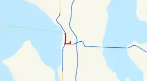 SR 519 is highlighted in red. | ||||
| Route information | ||||
| Auxiliary route of I-5 | ||||
| Defined by RCW 47.17.717 | ||||
| Maintained by WSDOT | ||||
| Length | 1.09 mi[1] (1.75 km) | |||
| Existed | 1991[2]–present | |||
| Major junctions | ||||
| South end | ||||
| North end | ||||
| Location | ||||
| Counties | King | |||
| Highway system | ||||
| ||||

Route description
_from_Columbia_Center.jpg.webp)
SR 519 begins as Edgar Martinez Drive, named for former Seattle Mariners Designated Hitter Edgar Martínez,[3] in the SoDo neighborhood of Seattle. The highway begins at an intersection between Edgar Martinez Drive, the western terminus of I-90, and 4th Avenue.[4] SR 519 travels west over BNSF Railway tracks, heading north to King Street Station,[5] and south of T-Mobile Park before it turns north onto Dave Niehaus Way, named for former Seattle Mariners sportscaster Dave Niehaus,[6] at an intersection with Atlantic Street. Dave Niehaus Way continues north between T-Mobile Park and CenturyLink Field to the east and SR 99 on the Alaskan Way Viaduct to the west before becoming 1st Avenue. SR 519 turns west onto Alaskan Way at the Port of Seattle on Pier 46, parallel to Elliott Bay, to end at an intersection with Yesler Way and Colman Dock at Pier 52.[7]
Every year, the Washington State Department of Transportation (WSDOT) conducts a series of surveys on its highways in the state to measure traffic volume. This is expressed in terms of average annual daily traffic (AADT), which is a measure of traffic volume for any average day of the year. In 2011, WSDOT calculated that between 38,000 and 102,000 vehicles per day used the highway, mostly at the Colman Dock.[8] WSDOT has designated SR 519 as a Highway of Statewide Significance, which includes principal arterials that are needed to connect major communities in the state.[9]
History
SR 519 was codified in 1991 as a state highway and began at the western terminus of I-90, then at 4th Avenue S., and traveled west onto Royal Brougham Way and north on Alaskan Way to Colman Dock.[2] The city streets in Seattle used by SR 519 were constructed after the series of regrades in the early 20th century filled a mudflat in SoDo.[10] By 1916, Alaskan Way (then known as Railroad Avenue) was paved and had its rails removed to handle growing traffic.[11][12] The Alaskan Way Viaduct was built above Alaskan Way between 1950 and 1953 and narrowed the street after Colman Dock was transferred to Washington State Ferries in 1951.[13][14] Ferry routes were incorporated into the state highway system in 1994, as SR 304 and SR 305 were extended to Seattle and SR 339 was created.[15]
WSDOT completed their South Seattle Intermodal Access Project in May 2010, which improved SR 519 and the western terminus of I-90 to better handle freight traffic heading to the Port of Seattle. New bridges over BNSF Railway tracks were built on Royal Brougham Way and off-ramps to I-90 that connect to Edgar Martinez Drive. SR 519 was later moved onto Edgar Martinez Drive in 2010 as a direct extension of I-90 after the construction of the new ramp and improvements to an intersection with Atlantic Street.[16][17] SR 519 is routed onto two streets named for Seattle Mariners personalities: Edgar Martinez Drive, dedicated in 2005,[3] and Dave Niehaus Way, dedicated in 2010.[6] During the construction of the Alaskan Way Viaduct replacement tunnel, WSDOT closed SR 519 and Alaskan Way between King Street and Yesler Way in May 2012, re-routing the highway to a temporary alignment.[18]
Major intersections
The entire highway is in Seattle, King County.
| mi[1] | km | Destinations | Notes | ||
|---|---|---|---|---|---|
| 0.00– 0.05 | 0.00– 0.080 | Interchange; west end of I-90, exit 1B westbound. | |||
| 0.24 | 0.39 | Southbound exit and northbound entrance with the Alaskan Way Viaduct | |||
| 1.09 | 1.75 | Alaskan Way continues north without designation | |||
| 1.000 mi = 1.609 km; 1.000 km = 0.621 mi | |||||
References
- Multimodal Planning Division (February 4, 2020). State Highway Log Planning Report 2019, SR 2 to SR 971 (PDF) (Report). Washington State Department of Transportation. pp. 1542–1543. Retrieved May 16, 2020.
- "47.17.717: State route No. 519". Revised Code of Washington. Washington State Legislature. 1991. Retrieved February 2, 2013.
- Vinh, Tan (March 6, 2005). "Slugger christens Edgar Martinez Drive". The Seattle Times. Retrieved February 2, 2013.
- "SR 519: Junction SR 90/Royal Brougham Way" (PDF). Washington State Department of Transportation. August 9, 2011. Retrieved February 2, 2013.
- 2011 Washington State Rail System (PDF) (Map). Washington State Department of Transportation. January 2012. Retrieved February 2, 2013.
- Baker, Geoff (April 5, 2011). "Street outside Safeco Field to be named "Dave Niehaus Way South"". The Seattle Times. Retrieved February 2, 2013.
- Google (February 2, 2013). "State Route 519" (Map). Google Maps. Google. Retrieved February 2, 2013.
- Staff (2011). "2011 Annual Traffic Report" (PDF). Washington State Department of Transportation. p. 195. Retrieved February 2, 2013.
- "Transportation Commission List of Highways of Statewide Significance" (PDF). Washington State Transportation Commission. July 26, 2009. Retrieved February 2, 2013.
- Dorpat, Paul (May 24, 2000). "Seattle Central Waterfront Tour, Part 6: From Railroad Avenue to Alaskan Way". HistoryLink. Retrieved February 2, 2013.
- Larson Anthropological Archaeological Services Limited (March 2004). "Draft Environmental Impact Statement - Appendix M: Archaeological Resources and Traditional Cultural Places Technical Memorandum" (PDF). Draft Environmental Impact Statement: SR 99: Alaskan Way Viaduct & Seawall Replacement Project. Washington State Department of Transportation. p. 67. Retrieved February 2, 2013.
- Ott, Jennifer (September 13, 2011). "Alaskan Way Viaduct, Part 1: Early Transportation Planning". HistoryLink. Retrieved February 2, 2013.
- Ott, Jennifer (December 19, 2011). "First section of Seattle's Alaskan Way Viaduct opens on April 4, 1953". HistoryLink. Retrieved February 2, 2013.
- Stein, Alan J. (June 2, 2001). "Turning Point 9: The Sound and the Ferry: The Birth of Washington State Ferries". HistoryLink. Retrieved February 2, 2013.
- Washington State Legislature (March 30, 1994). "Chapter 209: Substitute House Bill 2618 - Ferry Routes Included in State Highway Routes". Session Laws of the State of Washington. Session Laws of the State of Washington (1994 ed.). Olympia, Washington: Washington State Legislature. Retrieved February 2, 2013.
AN ACT Relating to state highway routes; amending RCW 47.17.080, 47.17.081, 47.17.175, 47.17.305, 47.17.317, 47.17.556, 47.17.560, and 47.17.735; and adding new sections to chapter 47.17 RCW.
- "SR 519 - S Seattle Intermodal Access - Complete May 2010". Washington State Department of Transportation. May 2010. Retrieved April 30, 2007.
- Staff (2010). "State Highway Log: Planning Report 2010, SR 2 to SR 971" (PDF). Washington State Department of Transportation. p. 5. Retrieved February 2, 2013.
- SR 99 Tunnel Project: Keeping waterfront traffic moving during SR 99 tunnel construction (JPG) (Map). Washington State Department of Transportation. May 2012. Retrieved February 2, 2013.
External links
| ||
| ||