Albany, New Hampshire
Albany is a town in Carroll County, New Hampshire, United States. The population was 735 at the 2010 census.[1]
Albany, New Hampshire | |
|---|---|
Town | |
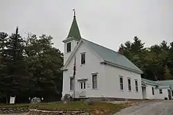 The Albany Chapel, Museum, and Town Offices | |
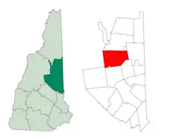 Location in Carroll County, New Hampshire | |
| Coordinates: 43°57′36″N 71°11′37″W | |
| Country | United States |
| State | New Hampshire |
| County | Carroll |
| Incorporated | 1833 |
| Villages | Albany Ferncroft |
| Government | |
| • Board of Selectmen | Rick Hiland, Chair Cathy Ryan Joe Ferris |
| Area | |
| • Total | 75.2 sq mi (194.7 km2) |
| • Land | 74.6 sq mi (193.2 km2) |
| • Water | 0.6 sq mi (1.5 km2) 0.77% |
| Elevation | 680 ft (207 m) |
| Population (2010) | |
| • Total | 735 |
| • Density | 9.8/sq mi (3.8/km2) |
| Time zone | UTC-5 (Eastern) |
| • Summer (DST) | UTC-4 (Eastern) |
| ZIP code | 03818 |
| Area code(s) | 603 |
| FIPS code | 33-00420 |
| GNIS feature ID | 0873526 |
| Website | www |
Albany includes Mount Chocorua and Mount Paugus, as well as the southeastern corner of the White Mountain National Forest. Albany is the entrance to the Mount Washington Valley, and features a 120-foot (37 m) covered bridge that spans the Swift River just north of the Kancamagus Highway. Albany is also home to the World Fellowship Center, an intergenerational camp and conference retreat center founded in 1941 by and for peace activists.[2]
History
The community was first chartered in 1766 by Colonial Governor Benning Wentworth as Burton for General Jonathan Burton of Wilton. The town was incorporated and renamed Albany in 1833, when the New York Central Railroad from New York City to Albany, New York, was chartered.
Geography
According to the United States Census Bureau, the town has a total area of 75.2 square miles (195 km2), of which 74.6 square miles (193 km2) is land and 0.6 square miles (1.6 km2) is water, comprising 0.77% of the town.[3] It is drained by the Swift River in the north and the Chocorua River in the south. Mount Chocorua, the highest point in Albany, has an elevation of 3,474 feet (1,059 m), and Mount Paugus has an elevation of 3,201 ft (976 m). Albany lies fully within the Saco River watershed.[4]
85% of the area of the town is part of the White Mountain National Forest.[5] Most residential development occurs in the southeastern portion of the town, along New Hampshire Route 16. Route 112, the Kancamagus Highway, runs east-west along the Swift River and is nearly entirely within the national forest. The former village of Passaconaway occupies a broad valley along the Kancamagus Highway in the northwestern part of the town. The area is now a national forest visitor attraction. Other place names within the town limits include Ferncroft, in the extreme southwest corner of town, and the former site of Paugus Mill, along the town's southern boundary.
Demographics
| Historical population | |||
|---|---|---|---|
| Census | Pop. | %± | |
| 1840 | 406 | — | |
| 1850 | 455 | 12.1% | |
| 1860 | 430 | −5.5% | |
| 1870 | 339 | −21.2% | |
| 1880 | 361 | 6.5% | |
| 1890 | 377 | 4.4% | |
| 1900 | 210 | −44.3% | |
| 1910 | 289 | 37.6% | |
| 1920 | 170 | −41.2% | |
| 1930 | 96 | −43.5% | |
| 1940 | 131 | 36.5% | |
| 1950 | 154 | 17.6% | |
| 1960 | 146 | −5.2% | |
| 1970 | 259 | 77.4% | |
| 1980 | 383 | 47.9% | |
| 1990 | 536 | 39.9% | |
| 2000 | 654 | 22.0% | |
| 2010 | 735 | 12.4% | |
| 2017 (est.) | 733 | [6] | −0.3% |
| U.S. Decennial Census[7] | |||
As of the census[8] of 2000, there were 654 people, 262 households, and 182 families residing in the town. The population density was 8.7 people per square mile (3.4/km2). There were 506 housing units at an average density of 6.8 per square mile (2.6/km2). The racial makeup of the town was 98.47% White, 0.15% African American, 0.31% Native American, 0.15% Asian, 0.31% Pacific Islander, and 0.61% from two or more races. Hispanic or Latino of any race were 0.76% of the population.
There were 262 households, out of which 34.7% had children under the age of 18 living with them, 51.5% were married couples living together, 10.7% had a female householder with no husband present, and 30.2% were non-families. 23.3% of all households were made up of individuals, and 7.3% had someone living alone who was 65 years of age or older. The average household size was 2.48 and the average family size was 2.85.
In the town, the population was spread out, with 26.5% under the age of 18, 6.1% from 18 to 24, 36.7% from 25 to 44, 22.8% from 45 to 64, and 8.0% who were 65 years of age or older. The median age was 37 years. For every 100 females, there were 100.6 males. For every 100 females age 18 and over, there were 102.1 males.
The median income for a household in the town was $36,635, and the median income for a family was $39,250. Males had a median income of $29,821 versus $20,250 for females. The per capita income for the town was $20,690. About 10.8% of families and 15.7% of the population were below the poverty line, including 23.9% of those under age 18 and 4.3% of those age 65 or over.
References
- United States Census Bureau, American FactFinder, 2010 Census figures. Retrieved March 23, 2011.
- http://www.worldfellowship.org
- "Geographic Identifiers: 2010 Demographic Profile Data (G001) - Albany town, New Hampshire". United States Census Bureau. Retrieved November 7, 2011.
- Foster, Debra H.; Batorfalvy, Tatianna N.; Medalie, Laura (1995). Water Use in New Hampshire: An Activities Guide for Teachers. U.S. Department of the Interior and U.S. Geological Survey.
- New Hampshire GRANIT state geographic information system Archived 2013-08-03 at the Wayback Machine
- "Annual Estimates of the Resident Population: April 1, 2010 to July 1, 2017 (PEPANNRES): Minor Civil Divisions – New Hampshire". Archived from the original on February 13, 2020. Retrieved November 14, 2018.
- "Census of Population and Housing". Census.gov. Retrieved June 4, 2016.
- "U.S. Census website". United States Census Bureau. Retrieved 2008-01-31.
External links
Places adjacent to Albany, New Hampshire | |
|---|---|
Municipalities and communities of Carroll County, New Hampshire, United States | ||
|---|---|---|
| Towns |  Map of New Hampshire highlighting Carroll County | |
| Township | ||
| CDPs | ||
| Other villages | ||
| ||
| Authority control |
|---|