Unorganized territory
In the United States, an unorganized territory is a region of land under U.S. sovereignty that is not within the bounds of a U.S. state and that is without a government established by the United States Congress through an organic act. The term was historically applied either to a newly acquired region not yet constituted as an organized incorporated territory (e.g. the Louisiana Purchase prior to the establishment of Orleans Territory and the District of Louisiana), or to a region previously part of an organized incorporated territory left "unorganized" after part of it had been organized and achieved the requirements for statehood (e.g. a large portion of Missouri Territory became unorganized territory for several years after its southeastern section became the state of Missouri). The U.S. currently exercises sovereignty over ten unorganized territories: American Samoa (the only one with a native resident population), Baker Island, Howland Island, Jarvis Island, Johnston Atoll, Kingman Reef, Midway Atoll, Navassa Island, Palmyra Atoll (previously a part of the Territory of Hawaii, and the only one that is an incorporated U.S. territory), and Wake Island.
U.S. territories
An unorganized territory can also be a United States territory for which the United States Congress has not enacted an organic act. In this sense, unorganized territories are territories over which the federal U.S. government is sovereign but which are not located within any of the states of the Union and have not been "organized" into self-governing units. Currently, all federal unorganized territories are insular areas, administered by the Office of Insular Affairs, U.S. Department of the Interior. American Samoa is technically unorganized, in that Congress has not passed an organic act, but it is effectively self-governing, under the terms of a constitution last revised in 1967. As of 2021, Palmyra Atoll (formerly part of the Territory of Hawaii) is the only unorganized incorporated U.S. territory. The other unorganized territories along with all of the organized territories are unincorporated. Incorporated territories are permanently part of the United States whereas unincorporated territories may be sold, leased or granted independence by the United States.
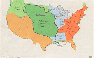
At various times during the 19th century, large parts of the Great Plains were unorganized territory. After the Louisiana Purchase from France in 1803, the entire region was part of the Louisiana Territory until 1812 and the Missouri Territory until 1821. In 1821 the Missouri Compromise created the State of Missouri from the territory, and the rest of the region was left unorganized. The Kansas–Nebraska Act of 1854 created the Kansas and Nebraska Territories, bringing organized government to the region once again. The creation of Kansas and Nebraska left the Indian Territory as the only unorganized territory in the Great Plains.
In 1858, the western part of the Minnesota Territory became unorganized when it was not included in the new state of Minnesota; this area was organized in 1861 as part of the Dakota Territory. On May 2, 1890, the western half of the Indian Territory was organized as Oklahoma. The remainder was incorporated into the State of Oklahoma upon its admission to the union in 1907.
Alaska was an unorganized territory between its acquisition from Russia in 1867 and the creation of Alaska Territory in 1912. Hawaii was as well from the time of its annexation by the U.S. in 1898 until organized as Hawaii Territory in 1900.
U.S. Census Bureau
Unorganized territories, as defined by the U.S. Census Bureau, occur in 10 minor civil division (MCD) states (Arkansas, Indiana, Iowa, Louisiana, Maine, Minnesota, North Carolina, North Dakota, Ohio, and South Dakota) where portions of counties are not included in any legally established MCD or independent incorporated place. The U.S. Census Bureau recognizes such separate pieces of territory as one or more separate county subdivisions for statistical purposes. It assigns each unorganized territory a descriptive name, followed by the designation "unorganized territory". Unorganized territories were first used for statistical purposes in conjunction with the 1960 census.[1]
At the 2000 census there were 305 of these territories within the United States. Their total land area was 85,392 square miles (221,165 km2) and they had a total population of 247,331. South Dakota had the most unorganized territories, 102, as well as the largest amount of land under that status: 39,785 square miles (103,042 km2), or 52.4% of the state's land area. North Dakota followed with 86 territories, 20,358 square miles (52,728 km2), or 29.5% of its land area. Maine was next with 36 territories, 14,052 square miles (36,396 km2), or 45.5% of its land area. Minnesota had 71 territories, 10,552 square miles (27,330 km2), or 13% of its land area. Several other states had small amounts of unorganized territory. The unorganized territory with the largest population was Camp Lejeune, North Carolina, a United States Marine Corps base with a census population of 34,452 inhabitants.
In the 2010 census, unorganized territory areas were identified in nine U.S. states: Arkansas, Indiana, Iowa, Maine, Minnesota, New York, North Carolina, North Dakota, and South Dakota.[2]
See also
- Territories of the United States
- Unorganized area, any geographic region in Canada that does not form part of a municipality or Indian reserve
- Unincorporated area
- Unparished area, areas of England outside any civil parish
References
- "Archived copy". Archived from the original on 2013-05-10. Retrieved 2017-12-07.CS1 maint: archived copy as title (link)
- U.S. Census Bureau, Geography Division (February 2011). "Geographic Terms and Concepts - County Subdivision". United States Census Bureau. Archived from the original on July 9, 2012. Retrieved July 10, 2012.
External links
- Unorganized Territory County Subdivisions United States Census Bureau