Alfredo Chaves
Alfredo Chaves is a municipality in the state of Espírito Santo, Brazil. It is 60 km southwest of the state capital, Vitória. Its population was 14,636 (2020) and its area is 615.79 km².[2]
Alfredo Chaves | |
|---|---|
.gif) Flag  Coat of arms | |
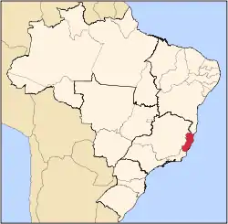
 Alfredo Chaves Location in Brazil | |
| Coordinates: 20°38′6″S 40°45′0″W | |
| Country | Brazil |
| Region | Southeast |
| State | Espírito Santo |
| Area | |
| • Total | 616 km2 (238 sq mi) |
| Population (2020 [1]) | |
| • Total | 14,636 |
| • Density | 24/km2 (62/sq mi) |
| Time zone | UTC-03:00 (BRT) |
| • Summer (DST) | UTC-02:00 (BRST) |
Geography
Located in the southeast of the state, it borders (east) Anchieta and Guarapari, (north) Marechal Floriano and Domingos Martins, (west) Vargem Alta, (south) Iconha and Rio Novo do Sul.
The municipality is mountainous, though not very high in general. Its highest peak is Trancenco Peak at 1,050 m above sea level. The town of Alfredo Chaves lies at 10 m above sea level.
Economy
The economy is mainly based on livestock, including cows (for milk) and chickens. In agriculture, coffee and banana plantations play an important role.
External links
Capital: Vitória | ||||||||||
| Mesoregion Central |
|  | ||||||||
| Mesoregion Litoral Norte |
| |||||||||
| Mesoregion Noroeste |
| |||||||||
| Mesoregion Sul |
| |||||||||
This article is issued from Wikipedia. The text is licensed under Creative Commons - Attribution - Sharealike. Additional terms may apply for the media files.