São Mateus, Espírito Santo
São Mateus is a municipality located in the Brazilian state of Espírito Santo. Its population was estimated at 132,642 in 2020, and its area is 2,346 km².[2] São Mateus is located at 36 meters above sea level.
São Mateus, Espírito Santo
Municipality of Espírito Santo | |
|---|---|
 View of São Mateus | |
 Flag  Seal | |
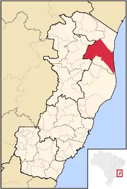 Location in the state of Espírito Santo and Brazil | |
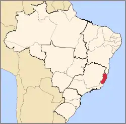
 São Mateus, Espírito Santo Location in Brazil | |
| Coordinates: 18°42′57″S 39°51′32″W | |
| Country | Brazil |
| Region | Central-West |
| State | Espírito Santo |
| Area | |
| • Total | 2,346.047 km2 (905.814 sq mi) |
| Elevation | 36 m (118 ft) |
| Population (2020 est.[2]) | |
| • Total | 132,642 |
| • Density | 57/km2 (150/sq mi) |
| Website | www |
It is the second oldest and seventh most populous municipality in the state of Espírito Santo, Brazil. São Mateus was founded on 21 of September 1544, receiving municipal autonomy only in 1764. Originally, it was called Povoado do Cricaré, being renamed in the year 1566 by Father José de Anchieta after Saint Matthew.
References
- "Brazilian Institute of Geography and Statistics" (in Portuguese). 2017. Retrieved 27 March 2019.
2018 Area Total
- IBGE 2020
Capital: Vitória | ||||||||||
| Mesoregion Central |
|  | ||||||||
| Mesoregion Litoral Norte |
| |||||||||
| Mesoregion Noroeste |
| |||||||||
| Mesoregion Sul |
| |||||||||
This article is issued from Wikipedia. The text is licensed under Creative Commons - Attribution - Sharealike. Additional terms may apply for the media files.