Conceição do Castelo
Conceição do Castelo is a municipality in central Espírito Santo, Brazil. Its population was 12,806 (2020) and its area is 369 km².[2]
Conceição do Castelo | |
|---|---|
 Flag  Coat of arms | |
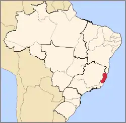
 Conceição do Castelo Location in Brazil | |
| Coordinates: 20°22′4″S 41°14′38″W | |
| Country | Brazil |
| Region | Southeast |
| State | Espírito Santo |
| Area | |
| • Total | 369 km2 (142 sq mi) |
| Population (2020 [1]) | |
| • Total | 12,806 |
| • Density | 35/km2 (90/sq mi) |
| Time zone | UTC-03:00 (BRT) |
| • Summer (DST) | UTC-02:00 (BRST) |
History
The municipality was created when it separated from Castelo on the 7th of May, 1964.
Location
Conceição do Castelo is about 120 km from the state capital Vitória. It stands in the mountainous region of the state, roughly southwest of the capital.
Economy
The economy is largely based on agriculture. Some important products are coffee, beans, maize, tomatoes and pigs, as well as cattle.
References
Capital: Vitória | ||||||||||
| Mesoregion Central |
|  | ||||||||
| Mesoregion Litoral Norte |
| |||||||||
| Mesoregion Noroeste |
| |||||||||
| Mesoregion Sul |
| |||||||||
This article is issued from Wikipedia. The text is licensed under Creative Commons - Attribution - Sharealike. Additional terms may apply for the media files.