Alma, Kansas
Alma is a city in and the county seat of Wabaunsee County, Kansas, United States.[8] As of the 2010 census, the city population was 832.[9]
Alma, Kansas | |
|---|---|
City and County seat | |
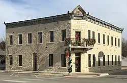 Brandt Hotel (2017) | |
| Nickname(s): "City of Native Stone Set in the Foothills"[1] | |
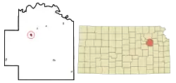 Location within Wabaunsee County and Kansas | |
 KDOT map of Wabaunsee County (legend) | |
| Coordinates: 39°0′56″N 96°17′21″W | |
| Country | United States |
| State | Kansas |
| County | Wabaunsee |
| Founded | 1867 |
| Incorporated | 1869[2] |
| Government | |
| • Type | Mayor–Council |
| • Mayor | Maurice Baker |
| Area | |
| • Total | 0.60 sq mi (1.55 km2) |
| • Land | 0.58 sq mi (1.51 km2) |
| • Water | 0.01 sq mi (0.04 km2) |
| Elevation | 1,106 ft (337 m) |
| Population | |
| • Total | 832 |
| • Estimate (2019)[5] | 780 |
| • Density | 1,333.33/sq mi (515.12/km2) |
| Time zone | UTC-6 (CST) |
| • Summer (DST) | UTC-5 (CDT) |
| ZIP codes | 66401, 66501 |
| Area code | 785 |
| FIPS code | 20-01350 [6] |
| GNIS ID | 0476598 [7] |
| Website | cityofalma-kansas.com |
History
19th century
.jpg.webp)
For millennia, the land now known as Kansas was inhabited by Native Americans. In 1803, most of modern Kansas was secured by the United States as part of the Louisiana Purchase. In 1854, the Kansas Territory was organized, then in 1861 Kansas became the 34th U.S. state. In 1859, Wabaunsee County was founded.
The first house was built at Alma in 1867.[10]
In 1887, the Chicago, Kansas and Nebraska Railway built a main line from Topeka through Alma to Herington.[11] The Chicago, Kansas and Nebraska Railway was foreclosed in 1891 and taken over by Chicago, Rock Island and Pacific Railway, which shut down in 1980. This line of the former Rock Island Railroad was sold to the Southern Pacific Railroad and later merged into the Union Pacific that operates and owns the line today. Most locals still refer to this railroad as the "Rock Island".
The city was named after either the city of Alma, Germany, or for a stream in the Ukraine.[12]
Geography
According to the United States Census Bureau, the city has a total area of 0.59 square miles (1.53 km2), of which, 0.58 square miles (1.50 km2) is land and 0.01 square miles (0.03 km2) is water.[13]
Demographics
| Historical population | |||
|---|---|---|---|
| Census | Pop. | %± | |
| 1880 | 362 | — | |
| 1890 | 1,125 | 210.8% | |
| 1900 | 966 | −14.1% | |
| 1910 | 1,010 | 4.6% | |
| 1920 | 789 | −21.9% | |
| 1930 | 811 | 2.8% | |
| 1940 | 776 | −4.3% | |
| 1950 | 716 | −7.7% | |
| 1960 | 838 | 17.0% | |
| 1970 | 905 | 8.0% | |
| 1980 | 925 | 2.2% | |
| 1990 | 871 | −5.8% | |
| 2000 | 797 | −8.5% | |
| 2010 | 832 | 4.4% | |
| 2019 (est.) | 780 | [5] | −6.2% |
| U.S. Decennial Census | |||
Alma is part of the Topeka, Kansas Metropolitan Statistical Area.
2010 census
As of the census[4] of 2010, there were 832 people, 342 households, and 212 families residing in the city. The population density was 1,434.5 inhabitants per square mile (553.9/km2). There were 381 housing units at an average density of 656.9 per square mile (253.6/km2). The racial makeup of the city was 96.4% White, 0.1% African American, 1.0% Native American, 0.2% from other races, and 2.3% from two or more races. Hispanic or Latino of any race were 3.7% of the population.
There were 342 households, of which 30.1% had children under the age of 18 living with them, 51.5% were married couples living together, 7.3% had a female householder with no husband present, 3.2% had a male householder with no wife present, and 38.0% were non-families. 34.5% of all households were made up of individuals, and 19.5% had someone living alone who was 65 years of age or older. The average household size was 2.35 and the average family size was 3.03.
The median age in the city was 42.7 years. 24.3% of residents were under the age of 18; 6.7% were between the ages of 18 and 24; 21.2% were from 25 to 44; 26.2% were from 45 to 64; and 21.5% were 65 years of age or older. The gender makeup of the city was 46.8% male and 53.2% female.
2000 census
As of the census[6] of 2000, there were 797 people, 315 households, and 208 families residing in the city. The population density was 1,410.3 people per square mile (539.9/km2). There were 354 housing units at an average density of 626.4 per square mile (239.8/km2). The racial makeup of the city was 96.86% White, 0.63% African American, 0.25% Native American, 0.63% from other races, and 1.63% from two or more races. Hispanic or Latino of any race were 3.26% of the population.
There were 315 households, out of which 28.6% had children under the age of 18 living with them, 54.6% were married couples living together, 8.3% had a female householder with no husband present, and 33.7% were non-families. 31.7% of all households were made up of individuals, and 17.5% had someone living alone who was 65 years of age or older. The average household size was 2.37 and the average family size was 2.94.
In the city, the population was spread out, with 24.3% under the age of 18, 6.6% from 18 to 24, 23.5% from 25 to 44, 22.1% from 45 to 64, and 23.5% who were 65 years of age or older. The median age was 42 years. For every 100 females, there were 90.7 males. For every 100 females age 18 and over, there were 90.2 males.
The median income for a household in the city was $38,333, and the median income for a family was $46,339. Males had a median income of $31,750 versus $21,094 for females. The per capita income for the city was $16,245. About 4.7% of families and 4.8% of the population were below the poverty line, including 3.0% of those under age 18 and 8.2% of those age 65 or over.
Education
The community is served by Wabaunsee USD 329 public school district. USD 329 was formed by school unification that consolidated Alma, Maple Hill, McFarland, and Paxico. Wabaunsee High School is located in Alma. The Wabaunsee High School mascot is Wabaunsee Chargers.[14]
Alma High School was closed through school unification. The Alma High School mascot was Blue Devils.[15]
Area events
- Hot Alma Nights is held on the third Saturday in August.[16]
See also
- Impact of the 2019–20 coronavirus pandemic on the meat industry in the United States
References
- "City of Alma, Kansas". City of Alma, Kansas. Retrieved August 17, 2012.
- "City of Alma". The League of Kansas Municipalities. May 26, 2019.
- "2019 U.S. Gazetteer Files". United States Census Bureau. Retrieved July 24, 2020.
- "U.S. Census website". United States Census Bureau. Retrieved 2012-07-06.
- "Population and Housing Unit Estimates". United States Census Bureau. May 24, 2020. Retrieved May 27, 2020.
- "U.S. Census website". United States Census Bureau. Retrieved 2008-01-31.
- "US Board on Geographic Names". United States Geological Survey. 2007-10-25. Retrieved 2008-01-31.
- "Find a County". National Association of Counties. Archived from the original on 2011-05-31. Retrieved 2011-06-07.
- "2010 City Population and Housing Occupancy Status". U.S. Census Bureau. Retrieved March 27, 2011.
- Blackmar, Frank Wilson (1912). Kansas: A Cyclopedia of State History, Embracing Events, Institutions, Industries, Counties, Cities, Towns, Prominent Persons, Etc. Standard Publishing Company. pp. 65.
- "Rock Island Rail History". Archived from the original on 2011-06-19. Retrieved 2011-04-18.
- "Profile for Alma, Kansas, KS". ePodunk. Retrieved August 17, 2012.
- "US Gazetteer files 2010". United States Census Bureau. Archived from the original on 2012-01-25. Retrieved 2012-07-06.
- "Wabaunsee USD 329". USD 329. Retrieved 4 January 2017.
- "Alma Blue Devils Belt Burlingame To Post Third Win", The Manhattan Mercury, 7 October 1962, p.11.
- Hot Alma Nights
Further reading
External links
| Wikimedia Commons has media related to Alma, Kansas. |
Municipalities and communities of Wabaunsee County, Kansas, United States | ||
|---|---|---|
| Cities | 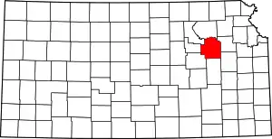 Map of Kansas highlighting Wabaunsee County | |
| Unincorporated communities | ||
| Ghost towns | ||
| Footnotes | ‡This populated place also has portions in an adjacent county or counties | |
| ||
| Authority control |
|
|---|