Wabaunsee, Kansas
Wabaunsee is an unincorporated community in Wabaunsee County, Kansas, United States. It was named for former Pottawatomi chief Wabaunsee.
Wabaunsee, Kansas | |
|---|---|
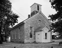 Beecher Bible and Rifle Church, located at the southeast corner of Chapel and Elm Streets | |
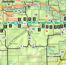 KDOT map of Wabaunsee County (legend) | |
| Coordinates: 39°8′46″N 96°20′46″W | |
| Country | United States |
| State | Kansas |
| County | Wabaunsee |
| Elevation | 1,030 ft (314 m) |
| Time zone | UTC-6 (CST) |
| • Summer (DST) | UTC-5 (CDT) |
| Area code | 785 |
| FIPS code | 20-03400 |
| GNIS feature ID | 476423 [1] |

History
Wabaunsee was founded in 1855 by a group of nearly 100 emigrants from New Haven, Connecticut. They were inspired by a sermon given by well-known abolitionist Henry Ward Beecher, who gave money to help supply rifles for the men to defend themselves. The rifles were smuggled through pro-slavery areas in crates marked "Beecher's Bibles."
Wabaunsee was staunchly anti-slavery and became part of the Underground Railroad in late 1856 and helped Lawrence after Quantrill's Raid. In 1862, the Beecher Bible and Rifle Church was completed and after the Civil War Wabaunsee hoped for a railroad but it was constructed north of the river.
Wabaunsee served as the county seat until after the Civil War, when the seat was transferred to Alma.[2]
Today, the town consists of several houses and buildings including the church which is on the National Register of Historic Places.
Geography
Wabaunsee is located about a half mile south of the Kansas River. It is located in Wabaunsee Township along K-18 two miles west of K-99.
Demographics
Wabaunsee is part of the Topeka, Kansas Metropolitan Statistical Area.
Education
The community is served by Wamego USD 320 public school district.
Transportation
I-70 is about nine miles south of Wabaunsee and US-24 is three miles north in Wamego. Most of the town is situated on the south side of K-18. Streets are maintained by the local county.
References
- "US Board on Geographic Names". United States Geological Survey. 2007-10-25. Retrieved 2008-01-31.
- Blackmar, Frank Wilson (1912). Kansas: A Cyclopedia of State History, Volume 2. Standard Publishing Company. pp. 850.
Further reading
External links
Municipalities and communities of Wabaunsee County, Kansas, United States | ||
|---|---|---|
| Cities | 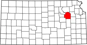 Map of Kansas highlighting Wabaunsee County | |
| Unincorporated communities | ||
| Ghost towns | ||
| Footnotes | ‡This populated place also has portions in an adjacent county or counties | |
| ||