St. Marys, Kansas
St. Marys is a city in Pottawatomie and Wabaunsee counties in the U.S. state of Kansas.[10] As of the 2010 census, the city population was 2,627.[11] It is home of Saint Mary's Academy and College.
Saint Marys, Kansas | |
|---|---|
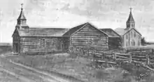
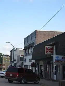 Downtown St. Marys (2009) | |
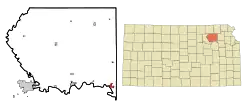 Location within Pottawatomie County and Kansas | |
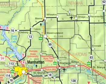 KDOT map of Pottawatomie County (legend) | |
| Coordinates: 39°11′47″N 96°4′7″W | |
| Country | United States |
| State | Kansas |
| Counties | Pottawatomie, Wabaunsee[1] |
| Founded | 1860s |
| Platted | 1866 |
| Incorporated | 1869 [2] |
| Named for | St. Mary's Mission |
| Government | |
| • Type | Mayor–Council |
| • Mayor | John-Paul Rutledge[3] |
| Area | |
| • Total | 1.18 sq mi (3.05 km2) |
| • Land | 1.18 sq mi (3.05 km2) |
| • Water | 0.00 sq mi (0.00 km2) |
| Elevation | 955 ft (291 m) |
| Population | |
| • Total | 2,627 |
| • Estimate (2019)[6] | 2,658 |
| • Density | 2,256.37/sq mi (871.16/km2) |
| Time zone | UTC-6 (CST) |
| • Summer (DST) | UTC-5 (CDT) |
| ZIP code | 66536 [7] |
| Area code | 785 |
| FIPS code | 20-62400 [8] |
| GNIS ID | 0476443 [9] |
| Website | smks.info |
History
St. Marys was laid out as a town in 1866.[12] It was named after the St. Mary's Mission.[13]
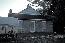
The oldest surviving mission building is the Pottawatomie Indian Pay Station which was built in 1855 and was used by government agents to pay an annuity to the Pottawatomie Indians who relocated to the area from the Great Lakes region. It was added to the National Register of Historic Places in 1972.
Geography
St. Marys is located at 39°11′47″N 96°4′7″W (39.196273, -96.068672),[14] on the Smoky Hill Trail and the Military Trail. According to the United States Census Bureau, the city has a total area of 1.18 square miles (3.06 km2), all of it land.[15]
The city is located approximately 20 miles west of Topeka on U.S. Route 24.
Demographics
| Historical population | |||
|---|---|---|---|
| Census | Pop. | %± | |
| 1880 | 884 | — | |
| 1890 | 1,174 | 32.8% | |
| 1900 | 1,390 | 18.4% | |
| 1910 | 1,397 | 0.5% | |
| 1920 | 1,321 | −5.4% | |
| 1930 | 1,304 | −1.3% | |
| 1940 | 1,132 | −13.2% | |
| 1950 | 1,201 | 6.1% | |
| 1960 | 1,509 | 25.6% | |
| 1970 | 1,434 | −5.0% | |
| 1980 | 1,598 | 11.4% | |
| 1990 | 1,791 | 12.1% | |
| 2000 | 2,198 | 22.7% | |
| 2010 | 2,627 | 19.5% | |
| 2019 (est.) | 2,658 | [6] | 1.2% |
| U.S. Decennial Census | |||
It is part of the Manhattan, Kansas Metropolitan Statistical Area.
2010 census
At the 2010 census there were 2,627 people, 836 households, and 560 families living in the city. The population density was 2,226.3 inhabitants per square mile (859.6/km2). There were 900 housing units at an average density of 762.7 per square mile (294.5/km2). The racial makeup of the city was 91.1% White, 1.1% African American, 1.4% Native American, 0.5% Asian, 2.3% from other races, and 3.6% from two or more races. Hispanic or Latino of any race were 9.0%.[5]
Of the 836 households 37.6% had children under the age of 18 living with them, 54.4% were married couples living together, 9.0% had a female householder with no husband present, 3.6% had a male householder with no wife present, and 33.0% were non-families. 29.5% of households were one person and 14.7% were one person aged 65 or older. The average household size was 3.10 and the average family size was 4.04.
The median age was 26.8 years. 38.5% of residents were under the age of 18; 9.6% were between the ages of 18 and 24; 19.8% were from 25 to 44; 18.7% were from 45 to 64; and 13.6% were 65 or older. The gender makeup of the city was 48.0% male and 52.0% female.
2000 census
At the 2000 census there were 2,198 people, 818 total households, and 525 families living in the city. The population density was 1,987.1 people per square mile (764.6/km2). There were 818 housing units at an average density of 739.5 per square mile (284.5/km2). The racial makeup of the city was 95.18% White, 0.91% African American, 1.36% Native American, 0.50% Asian, 0.50% from other races, and 1.55% from two or more races. Hispanic or Latino of any race were 4.14%.[8]
Of the 818 households 35.5% had children under the age of 18 living with them, 56.8% were married couples living together, 9.2% had a female householder with no husband present, and 31.2% were non-families. 29.7% of households were one person and 12.4% were one person aged 65 or older. The average household size was 2.83 and the average family size was 3.61.
The age distribution was 35.4% under the age of 18, 7.6% from 18 to 24, 24.0% from 25 to 44, 17.9% from 45 to 64, and 15.0% 65 or older. The median age was 31 years. For every 100 females, there were 91.3 males. For every 100 females age 18 and over, there were 88.4 males.
The median household income was $28,083 and the median family income was $28,063. Males had a median income of $25,595 versus $23,750 for females. The per capita income for the city was $15,536. About 26.2% of families and 31.1% of the population were below the poverty line, including 17.1% of those under age 18 and 27.2% of those age 65 or over.
Education
The community is served by Kaw Valley USD 321 public school district, which is located in St. Marys. Besides providing education from pre-K to 12 in St. Marys, it also services students in a four-county radius with four other attendance centers. Its high school is St. Marys High School.
A private school, St. Mary's Academy and College includes grades K-12 as well as a two-year college program. The Society of Saint Pius X operates the school.
References
- "Subcounty population estimates: Kansas 2000-2007". United States Census Bureau, Population Division. 2009-03-18. Archived from the original (CSV) on 2009-03-31. Retrieved 2009-04-04.
- "City of St. Marys". The League of Kansas Municipalities. May 28, 2019.
- "Govt". City of Saint Marys. Retrieved 2020-02-15.
- "2019 U.S. Gazetteer Files". United States Census Bureau. Retrieved July 24, 2020.
- "U.S. Census website". United States Census Bureau. Retrieved 2012-07-06.
- "Population and Housing Unit Estimates". United States Census Bureau. May 24, 2020. Retrieved May 27, 2020.
- United States Postal Service (2012). "USPS - Look Up a ZIP Code". Retrieved 2012-02-15.
- "U.S. Census website". United States Census Bureau. Retrieved 2008-01-31.
- "US Board on Geographic Names". United States Geological Survey. 2007-10-25. Retrieved 2008-01-31.
- "Geographic Names Information System". United States Geological Survey. Retrieved 2008-01-31.
- "2010 City Population and Housing Occupancy Status". U.S. Census Bureau. Retrieved December 2, 2011.
- Blackmar, Frank Wilson (1912). Kansas: A Cyclopedia of State History, Volume 2. Standard Publishing Company. p. 632.
- Kansas State Historical Society (1916). Biennial Report of the Board of Directors of the Kansas State Historical Society. Kansas State Printing Plant. p. 263.
- "US Gazetteer files: 2010, 2000, and 1990". United States Census Bureau. 2011-02-12. Retrieved 2011-04-23.
- "US Gazetteer files 2010". United States Census Bureau. Archived from the original on 2012-01-25. Retrieved 2012-07-06.
Further reading
External links
| Wikimedia Commons has media related to St. Marys, Kansas. |
Municipalities and communities of Pottawatomie County, Kansas, United States | ||
|---|---|---|
| Cities | 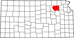 Map of Kansas highlighting Pottawatomie County | |
| Unincorporated communities | ||
| Footnotes | ‡This populated place also has portions in an adjacent county or counties | |
| ||
Municipalities and communities of Wabaunsee County, Kansas, United States | ||
|---|---|---|
| Cities | 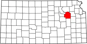 Map of Kansas highlighting Wabaunsee County | |
| Unincorporated communities | ||
| Ghost towns | ||
| Footnotes | ‡This populated place also has portions in an adjacent county or counties | |
| ||
| Authority control |
|---|