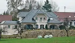
Althütte
Althütte is a municipality of the Rems-Murr district in Baden-Württemberg, Germany.
Althütte | |
|---|---|
 | |
 Coat of arms | |
Location of Althütte within Rems-Murr-Kreis district 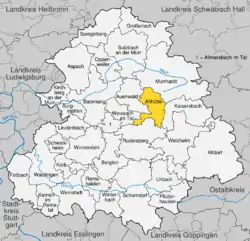 | |
 Althütte  Althütte | |
| Coordinates: 48°54′47″N 09°34′19″E | |
| Country | Germany |
| State | Baden-Württemberg |
| Admin. region | Stuttgart |
| District | Rems-Murr-Kreis |
| Area | |
| • Total | 18.15 km2 (7.01 sq mi) |
| Elevation | 497 m (1,631 ft) |
| Population (2019-12-31)[1] | |
| • Total | 4,242 |
| • Density | 230/km2 (610/sq mi) |
| Time zone | UTC+01:00 (CET) |
| • Summer (DST) | UTC+02:00 (CEST) |
| Postal codes | 71566 |
| Dialling codes | 07183 |
| Vehicle registration | WN |
| Website | www |
History
The modern municipality of Althütte was formed by the merging of the villages of Althütte and Sechselberg in 1971.[2]
Geography
The municipality (Gemeinde) of Althütte is located in the Rems-Murr district, in the German state of Baden-Württemberg. Althütte is physically located in the Murrhardt Forest, a region of the larger Swabian-Franconian Forest. Elevation above sea level in the municipal area ranges from a high of 571 meters (1,873 ft) Normalnull (NN) to a low of 339 meters (1,112 ft) NN.[2]
Portions of the Federally protected Hörschbachschlucht and Strümpfelbach valley nature reserves are located in Althütte's municipal area.[2]
Politics
Althütte has two boroughs (Ortsteile), and 16 villages: Fautspach, Gallenhof, Glaitenhof, Hahnenhof, Hörschhof, Hörschhöfer Sägmühle, Kallenberg, Klösterle, Lutzenberg, Nonnenmühle, Rottmannsberger Sägmühle, Schlichenhöfle, Schlichenweiler, Schöllhütte, Voggenhof, and Waldenweiler. Althütte is in an mutually-beneficial municipal association with the city of Backnang and the municipalities of Allmersbach im Tal, Aspach, Auenwald, Burgstetten, Kirchberg an der Murr, Oppenweiler, and Weissach im Tal.[2]
Coat of arms
Althütte's municipal coat of arms displays two white glassblowing pipes crossed over a field of blue. The coat of arms refers to the name Althütte and to Althütte's history of glassworking. This coat of arms was created from a proposal by the Central State Archive Stuttgart in 1924.[2]
Transportation
Althütte is connected to Germany's network of roadways by its local Landesstraßen and Kreisstraßen. Local public transportation is provided by the Verkehrs- und Tarifverbund Stuttgart.[2]
References
- "Bevölkerung nach Nationalität und Geschlecht am 31. Dezember 2019". Statistisches Landesamt Baden-Württemberg (in German). September 2020.
- "Althütte". LEO-BW (in German). Baden-Württemberg. Retrieved 31 July 2020.
External links
| Wikimedia Commons has media related to Althütte. |
- Official website
 (in German)