Plüderhausen
Plüderhausen is a municipality east of Schorndorf in the Rems-Murr district in Baden-Württemberg, Germany. It belongs to the Stuttgart Metropolitan Region.
Plüderhausen | |
|---|---|
 Old town hall, built in 1569 | |
 Coat of arms | |
Location of Plüderhausen 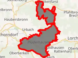
| |
 Plüderhausen 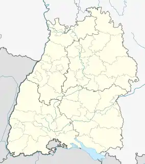 Plüderhausen | |
| Coordinates: 48°47′42″N 09°36′04″E | |
| Country | Germany |
| State | Baden-Württemberg |
| Admin. region | Stuttgart |
| District | Rems-Murr-Kreis |
| Government | |
| • Mayor | Andreas Schaffer |
| Area | |
| • Total | 26.13 km2 (10.09 sq mi) |
| Elevation | 274 m (899 ft) |
| Population (2019-12-31)[1] | |
| • Total | 9,604 |
| • Density | 370/km2 (950/sq mi) |
| Time zone | UTC+01:00 (CET) |
| • Summer (DST) | UTC+02:00 (CEST) |
| Postal codes | 73655 |
| Dialling codes | 07181 |
| Vehicle registration | WN |
| Website | www.pluederhausen.de |
Geography
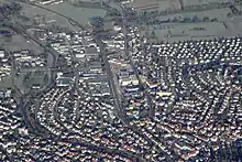
The municipality of Plüderhausen lies in the Rems Valley, nestled between the heights of the Schurwald and the Welzheimer Forest at an elevation ranging between 260 and 505 m, with the town center at 274 m.
Neighboring Towns and Municipalities
The municipality of Plüderhausen is bordered to the north by Welzheim, to the east by Waldhausen (Lorch), to the southeast by Börtlingen, to the south by Adelberg, to the west by Schorndorf, and to the northwest by Urbach.
Community Structure
The municipality of Plüderhausen consists of the villages of Plüderhausen and Walkersbach, the hamlet of Aichenbachhof, and the smaller communities of Eibenhof, Köshof, Neuweilerhof, Plüderwiesenhof and Schautenhof. The abandoned villages of Linthalten, Neuweiler und Tannschöpflenshof are also located within the municipal boundaries.[2][3] The municipality is additionally divided into the two residential districts of Plüderhausen (with Plüderhausen, Plüderwiesenhof, Aichenbachhof and Neuweilerhof) and Walkersbach (with Walkersbach, Schautenhof, Köshof und Eibenhof).[4]
A narrow wedge of the Urbach district, which extends northeast to the Walkersbach valley, divides the municipality of Plüderhausen into a larger southern part around Plüderhausen village and a smaller northern part around Walkersbach village. Additionally, there is a very small municipal exclave around Schautenhof north of Walkersbach.
Development of the Municipal District
Incorporations
- Aichenbachhof, Walkersbach
Population Growth
|
|
History
In the earliest known documentary record from 1142, Plüderhausen was referred to as "Pliderhusen," a name derived from the Old High German blidheri, which roughly means "happy army."[5] During the Hohenstaufen Dynasty Plüderhausen came under the authority of the Hohenstaufen Ministeriales based in Elisabethenberg bei Waldhausen. From 1246 Plüderhausen was governed by the Dukes of Württemberg, under the Vogtei of Schorndorf from 1421.[6] The district of Walkersbach was first mentioned in 1262, but is presumably older than the date suggests.[7]
In 1519 Jörg Staufer, a member of the Swabian League, burned down the Plüderhausen church and 80 homes during a military campaign against Duke Ulrich of Württemberg. The church was rebuilt the same year. The Protestant Reformation swept Plüderhausen in 1536. As Prince Elector John Frederick of Saxony initiated his retreat in 1546 after defeat in the Schmalkaldic War, he and his army spent the night of 27–28 November in Plüderhausen, prompting complaints by the Obervogt of Schorndorf about the bad behavior of the robbing and plundering troops.[6][8][9]
In 1626 the cemetery was laid out, and is still used today.[8] Many of Plüderhäusen's inhabitants died as a result of the Thirty Years' War, and many fled, so that of the approximately 1,800 inhabitants at the beginning of the war, only 57 remained at its end. Seven years later there were around 700 inhabitants again.[9] Barely recovered, the town was plundered again by the French under Villars in 1707. From 1793 through 1813 the French Revolutionary Wars and Napoleonic Wars unleashed countless brutal marches of Soldateska through the region.[9]
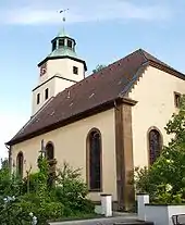
In 1804 Saint Margaret's Church was built to replace the church rebuilt in 1519; the original choir and tower were preserved. In 1805 Plüderhausen gained market right. In 1807 Walkersbach, which lay about 5 kilometers to the northwest, became a district of Plüderhausen.[8] In a description from 1845, the regional administration of the Welzheim Oberamt noted Plüderhäusen to be an agricultural region and emphasized the importance of the district's fruit-growing.[6] The Cannstatt–Wasseralfingen branch of the Rems Railway provided Plüderhausen with a rail connection in 1861, leading to growing industrialization.[8] In 1863 master baker Jakob Friedrich Schüle began mechanical production of Spätzle and noodles, later establishing a factory Schüle-Hohenlohe AG, for egg dough products.[6]
In 1907 the Castle Garden Elementary School was built, and the new City Hall was built in 1914.[8]
Plüderhausen was not damaged in World War II, and was surrendered to the United States Army on 20 April 1945 without a struggle.[6]
In 1963 the first annual Plüderhäuser Festival Days took place.[9]
Religion
There has been a church in Plüderhausen since 1295. It was originally dedicated to Peter and Paul, then to St. Margaret since 1537. The present evangelical Church of St. Margaret was built in the 15th century. The evangelical church congregation belonged to the Welzheim church district until its 1978 dissolution. Ever since the congregation belongs to the Schorndorf district.
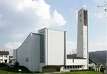
There are 7 churches in Plüderhausen today:
- the Evangelical Church of St. Margaret (EKD)
- the Roman Catholic Sacred Heart Church
- the Evangelical Methodist Church (EmK/UMC)
- Church of God - Christian Central Life
- New Apostolic Church
- South German Fellowship
- Peoples' Mission of Decided Christians.
Personality
- The Austrian jazz musician Oscar Klein (1930–2006) lived most recently in Plüderhausen.
- Dieter Kleinmann (born 1953), Member of Parliament (FDP), grew up in Plüderhausen and was here alderman.
Sons and daughters of the town
- Sixt Jacob von Kapff (1735–1821), lawyer and professor in Tübingen
- Erich Retter (1925–2014), football player
- Joachim Speidel (born 1947), electrical engineer, professor of communication at the University of Stuttgart
References
- "Bevölkerung nach Nationalität und Geschlecht am 31. Dezember 2019". Statistisches Landesamt Baden-Württemberg (in German). September 2020.
- According to topographical maps, Tannschöpflenshof lies west of the Pfahlbronner mill on the hilltop south of Heuberg.
- Das Land Baden-Württemberg. Amtliche Beschreibung nach Kreisen und Gemeinden. Band III: Regierungsbezirk Stuttgart, Regionalverband Mittlerer Neckar. Kohlhammer, Stuttgart 1978, ISBN 3-17-004758-2. S. 534–536
- Hauptsatzung der Gemeinde Plüderhausen vom 29. November 2001
- O.H.G. blidi "gay, friendly," cf. Eng. blithe, . O.H.G. heri "army," cf. Ger. Heer, Eng. harry, .
- Aichele, Wilhelm (1957). Das Remstal. Schwäbisch Gmünd: self published. pp. 140 ff.
- Gemeinde Plüderhausen | Info | Geschichte | Walkersbach Archived 2014-03-19 at the Wayback Machine, Gemeinde Plüderhausen, accessed on 15 May 2012
- Gemeinde Plüderhausen | Info | Geschichte Archived 2012-07-24 at the Wayback Machine, Gemeinde Plüderhausen, accessed on 15 May 2012
- Gemeinde Plüderhausen | Info | Geschichte | Plüderhausen Archived 2010-01-07 at the Wayback Machine, Gemeinde Plüderhausen, accessed on 15 May 2012