An-Nazla al-Gharbiya
An-Nazla al-Gharbiya (Arabic: النزله الغربيه) is a Palestinian village in the Tulkarm Governorate in the eastern West Bank, located 16 kilometers North of Tulkarm.
an-Nazla al-Gharbiya | |
|---|---|
| Arabic transcription(s) | |
| • Arabic | النزله الغربيه |
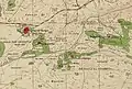
 an-Nazla al-Gharbiya Location of an-Nazla al-Gharbiya within Palestine | |
| Coordinates: 32°24′10″N 35°05′04″E | |
| Palestine grid | 158/200 |
| State | State of Palestine |
| Governorate | Tulkarm |
| Government | |
| • Type | Village council |
| Population (2006) | |
| • Total | 885 |
| Name meaning | Nuzlet et Tinat: the settlement of the fig-trees[1] |
History
Pottery remains from the Roman era have been found here.[2]
Southwest of the village, on the top of hill, is the tomb of Sheikh Khalil. It is constructed of old, reused stones, and pottery sherds from the Byzantine era have been found here.[2][3]
Pottery from the early Muslim and the Middle Ages have been found here.[2]
Ottoman era
In 1882, the PEF's Survey of Western Palestine described An-Nazla al-Gharbiya, then called Nuzlet et Tinat: "A little hamlet with fig trees, and a well to the west on low ground. It has caves opposite to it on the south."[4]
British Mandate era
In the 1931 census of Palestine, conducted by the British Mandate authorities, Nazla al Gharbiya had a population of 64 Muslims, in a total of 13 houses.[5]
In the 1945 statistics the population of Nazla el Gharbiya was 100 Muslims,[6] with 2,320 dunams of land according to an official land and population survey.[7] Of this, 182 dunams were plantations and irrigable land, 556 were used for cereals,[8] while 2 dunams were built-up (urban) land.[9]
 an-Nazla al-Gharbiya 1942 1:20,000
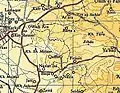 an-Nazla al-Gharbiya 1945 1:250,000
Jordanian era
In the wake of the 1948 Arab–Israeli War, and after the 1949 Armistice Agreements, An-Nazla al-Gharbiya came under Jordanian rule.
In 1961, the population of Nazla Gharbiya was 187.[10]
Post 1967
After the Six-Day War in 1967, An-Nazla al-Gharbiya has been under Israeli occupation.
According to the Palestinian Central Bureau of Statistics, an-Nazla al-Gharbiya had a population of approximately 885 inhabitants in mid-year 2006.[11] 6.1% of the population of an-Nazla al-Gharbiya were refugees in 1997.[12] The healthcare facilities for the surrounding villages are based in Baqa ash-Sharqiyya, where the facilities are designated as MOH level 3.[13]
References
- Palmer, 1881, p. 189
- Zertal, 2016, p. 355
- Dauphin, 1998, p. 756
- Conder and Kitchener, 1882, SWP II, p. 153
- Mills, 1932, p. 70
- Government of Palestine, Department of Statistics, 1945, p. 21
- Government of Palestine, Department of Statistics. Village Statistics, April, 1945. Quoted in Hadawi, 1970, p. 76 Archived 2017-08-08 at the Wayback Machine
- Government of Palestine, Department of Statistics. Village Statistics, April, 1945. Quoted in Hadawi, 1970, p. 127
- Government of Palestine, Department of Statistics. Village Statistics, April, 1945. Quoted in Hadawi, 1970, p. 177
- Government of Jordan, 1964, p. 27
- Projected Mid -Year Population for Tulkarm Governorate by Locality 2004- 2006 Palestinian Central Bureau of Statistics.
- Palestinian Population by Locality and Refugee Status Palestinian Central Bureau of Statistics
- Health care Facilities Tulkarm Governorate
Bibliography
- Barron, J.B., ed. (1923). Palestine: Report and General Abstracts of the Census of 1922. Government of Palestine.
- Conder, C.R.; Kitchener, H.H. (1882). The Survey of Western Palestine: Memoirs of the Topography, Orography, Hydrography, and Archaeology. 2. London: Committee of the Palestine Exploration Fund.
- Dauphin, Claudine (1998). La Palestine byzantine, Peuplement et Populations. BAR International Series 726 (in French). III : Catalogue. Oxford: Archeopress. ISBN 0-860549-05-4.
- Government of Jordan, Department of Statistics (1964). First Census of Population and Housing. Volume I: Final Tables; General Characteristics of the Population (PDF).
- Government of Palestine, Department of Statistics (1945). Village Statistics, April, 1945.
- Hadawi, S. (1970). Village Statistics of 1945: A Classification of Land and Area ownership in Palestine. Palestine Liberation Organization Research Center. Archived from the original on 2018-12-08. Retrieved 2014-09-11.
- Mills, E., ed. (1932). Census of Palestine 1931. Population of Villages, Towns and Administrative Areas. Jerusalem: Government of Palestine.
- Palmer, E.H. (1881). The Survey of Western Palestine: Arabic and English Name Lists Collected During the Survey by Lieutenants Conder and Kitchener, R. E. Transliterated and Explained by E.H. Palmer. Committee of the Palestine Exploration Fund.
- Zertal, A. (2016). The Manasseh Hill Country Survey. 3. Boston: BRILL. ISBN 9004312307.
External links
- Welcome To al-Nazla al-Gharbiya
- Survey of Western Palestine, Map 11: IAA, Wikimedia commons
