Antelope, Oregon
Antelope is a city in Wasco County, Oregon, United States. It had an estimated population of 47 people as of 2012.[6][1] The town was incorporated in 1901, though it was founded earlier. The City of Antelope was originally a stage and freight wagon road stop on the Old Dalles to Canyon City Trail. Howard Maupin came to Antelope in 1863 to operate a horse ranch, becoming the caretaker of the stage station that was established by Henry Wheeler in 1864. Maupin began raising cattle to provide meat for travelers. Nathan Wallace, who is sometimes credited with being Antelope's first postmaster, acquired the Antelope stage station from Maupin in 1870. Records indicate the community was considered to have been established in 1872.
Antelope, Oregon | |
|---|---|
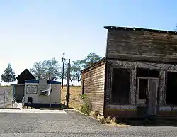 Post office and abandoned building in Antelope | |
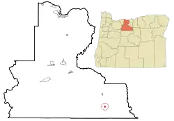 Location in Oregon | |
| Coordinates: 44°54′39″N 120°43′22″W | |
| Country | United States |
| State | Oregon |
| County | Wasco |
| Incorporated | 1901 |
| Government | |
| • Mayor | Peggy Sue Tucker |
| Area | |
| • Total | 0.46 sq mi (1.19 km2) |
| • Land | 0.46 sq mi (1.19 km2) |
| • Water | 0.00 sq mi (0.00 km2) |
| Elevation | 2,654 ft (809 m) |
| Population | |
| • Total | 46 |
| • Estimate (2019)[4] | 50 |
| • Density | 108.46/sq mi (41.84/km2) |
| Time zone | UTC-8 (Pacific) |
| • Summer (DST) | UTC-7 (Pacific) |
| ZIP code | 97001 |
| Area code(s) | 541 |
| FIPS code | 41-02250[3] |
| GNIS feature ID | 1116966[5] |
| Website | cityofantelope.us |
In the early 1980s, members of the Rajneesh movement moved in and effectively took over the government of the city by outnumbering the original residents with new voter registrations. On September 18, 1984, a vote was held and the city was renamed to "Rajneesh, Oregon". By 1985, after several of the Rajneesh movement leaders were discovered to have been involved in criminal behavior (including a mass food poisoning attack and an aborted plot to assassinate a U.S. Attorney), their guru left the country as part of a negotiated settlement of federal immigration fraud charges, and the Rajneesh commune collapsed. On November 6, 1985, the city voted to rename itself back to Antelope.
History
The Antelope Valley was probably named by European-American members of Joseph Sherar's party, who were packing supplies to mines in the John Day area.[7] Sherar became known as the operator of a toll bridge across the Deschutes River, on a cut-off of the Barlow Road.[8] There were many pronghorns (often called pronghorn antelope) in the area in the early 19th century.[7]
_(wascDA0063).jpg.webp)
In the mid-19th century, Antelope was along the wagon road connecting The Dalles on the Columbia River with gold mines near Canyon City. After about 1870, the wagon road became known as The Dalles Military Road.[9] The road crossed the Deschutes River on Sherar's Bridge.[10]
The Antelope post office was established in 1871, with Howard Maupin, founder of Maupin, Oregon, as the first postmaster.[7] The town's population peaked around 1900,[11] shortly after the Columbia Southern Railway completed a 70-mile (110 km) rail line from Biggs, on the Columbia River, to Shaniko, a few miles north of Antelope.[12] The railroad timetable for September 9, 1900, lists a daily stagecoach run from the train terminal in Shaniko to Antelope and beyond.[12] Antelope was incorporated by the Oregon Legislative Assembly on January 29, 1901.
The Rajneeshpuram, a commune started by the Rajneesh movement, was established near the town in 1981. The organization collapsed in 1985 following the discovery by the authorities of criminal activities, such as the 1984 Rajneeshee bioterror attack. On September 18, 1984, a vote was held and the city was renamed to "Rajneesh".[13]
On November 6, 1985, the remaining residents, which included both original residents and some remaining Rajneeshees, voted 34 to 0 to restore the original name, and it was subsequently restored in 1986.[1] The U.S. Postal Service had never recognized the change of name.[7]
Subsequent to the collapse of the commune, the property reverted to ownership by the State of Oregon for non-payment of taxes, and was sold to Montana billionaire Dennis Washington in 1991 for $3.65 million.[14] Currently, the ranch, 18 miles (29 km) from Antelope,[15] is operated by Young Life, a Christian parachurch organization. It has been converted into a Christian youth camp known as "Washington Family Ranch".[16]
The events of the mid-1980s that involved the city were the subject of the 2003 Forensic Files program "Bio Attack," and a 2018 Netflix documentary Wild Wild Country.
Geography
Antelope, in Wasco County in north-central Oregon, is along Oregon Route 218 just north of its intersection with Oregon Route 293.[17] By highway, the city is 34 miles (55 km) northeast of Madras and 143 miles (230 km) east of Portland.[18] Antelope Creek, in the Deschutes River watershed, flows by Antelope.[17]
The city is at an elevation of 2,654 feet (809 m) above sea level.[5] According to the United States Census Bureau, the city has a total area of 0.48 square miles (1.24 km2), all of it land.[19]
Climate
According to the Köppen climate classification system, Antelope has a warm-summer Mediterranean climate (Köppen Csb).
| Climate data for Antelope | |||||||||||||
|---|---|---|---|---|---|---|---|---|---|---|---|---|---|
| Month | Jan | Feb | Mar | Apr | May | Jun | Jul | Aug | Sep | Oct | Nov | Dec | Year |
| Record high °F (°C) | 65 (18) |
72 (22) |
78 (26) |
90 (32) |
98 (37) |
103 (39) |
107 (42) |
109 (43) |
105 (41) |
91 (33) |
76 (24) |
72 (22) |
109 (43) |
| Average high °F (°C) | 40 (4) |
45.3 (7.4) |
52 (11) |
59.1 (15.1) |
67.2 (19.6) |
75.3 (24.1) |
85.6 (29.8) |
84.5 (29.2) |
76.1 (24.5) |
63.9 (17.7) |
49.4 (9.7) |
41.4 (5.2) |
61.6 (16.4) |
| Average low °F (°C) | 23.3 (−4.8) |
26.3 (−3.2) |
29.4 (−1.4) |
32.7 (0.4) |
38.1 (3.4) |
44.2 (6.8) |
49.7 (9.8) |
49 (9) |
42.8 (6.0) |
35.5 (1.9) |
29.1 (−1.6) |
24.7 (−4.1) |
35.4 (1.9) |
| Record low °F (°C) | −27 (−33) |
−22 (−30) |
5 (−15) |
11 (−12) |
10 (−12) |
12 (−11) |
29 (−2) |
30 (−1) |
20 (−7) |
8 (−13) |
−7 (−22) |
−20 (−29) |
−27 (−33) |
| Average precipitation inches (mm) | 1.59 (40) |
1.14 (29) |
1.13 (29) |
1.03 (26) |
1.39 (35) |
1.05 (27) |
0.33 (8.4) |
0.49 (12) |
0.66 (17) |
0.97 (25) |
1.65 (42) |
1.71 (43) |
13.14 (334) |
| Average snowfall inches (cm) | 7.1 (18) |
3.3 (8.4) |
2.2 (5.6) |
1.1 (2.8) |
0.1 (0.25) |
0 (0) |
0 (0) |
0 (0) |
0.1 (0.25) |
0.1 (0.25) |
1.8 (4.6) |
5.2 (13) |
21.1 (54) |
| Average precipitation days | 11 | 9 | 10 | 8 | 8 | 6 | 2 | 3 | 4 | 6 | 11 | 11 | 89 |
| Source: [20] | |||||||||||||
Demographics
| Historical population | |||
|---|---|---|---|
| Census | Pop. | %± | |
| 1890 | 184 | — | |
| 1900 | 249 | 35.3% | |
| 1910 | 175 | −29.7% | |
| 1920 | 199 | 13.7% | |
| 1930 | 136 | −31.7% | |
| 1940 | 90 | −33.8% | |
| 1950 | 60 | −33.3% | |
| 1960 | 46 | −23.3% | |
| 1970 | 51 | 10.9% | |
| 1980 | 39 | −23.5% | |
| 1990 | 34 | −12.8% | |
| 2000 | 59 | 73.5% | |
| 2010 | 46 | −22.0% | |
| 2019 (est.) | 50 | [4] | 8.7% |
| source:[3][11] | |||
2010 census
As of the census of 2010, there were 46 people, 28 households, and 10 families residing in the city. The population density was 96 inhabitants per square mile (37.1/km2). There were 43 housing units at an average density of 90 per square mile (34.7/km2). The racial makeup of the city was 91.3% White (42 people), 2.2% Native American (1 person), 2.2% Asian (1 person), and 4.3% from two or more races (2 people).[3]
There were 28 households, of which 11% (3 households) had children under the age of 18 living with them, 21% (6 households) were married couples living together, 4% (1 household) had a female householder with no husband present, 11% (3 households) had a male householder with no wife present, and 64% (18 households) were non-families. About 61% (17 households) of all households were made up of individuals, and 46% (13 households) had someone living alone who was 65 years of age or older. The average household size was 1.64 and the average family size was 2.70.[3]
The median age in the city was 62 years. About 15% of residents (7 people) were under the age of 18; 2% (1 person) were between the ages of 18 and 24; 11% (5 people) were from 25 to 44; 30.3% (14 people) were from 45 to 64; and 41% (19 people) were 65 years of age or older. The gender makeup of the city was 52% (24 people) male and 48% (22 people) female.[3]
.jpg.webp)
Footnotes
- "Antelope Oregon", Official City of Antelope Oregon Website, retrieved June 14, 2018
- "2019 U.S. Gazetteer Files". United States Census Bureau. Retrieved July 28, 2020.
- "U.S. Census website". U.S. Census Bureau. Retrieved August 10, 2013.
(As of 2018-06-14, the archive is not functioning to provide the cited information and the original link is not a dead link.)
- "Population and Housing Unit Estimates". United States Census Bureau. May 24, 2020. Retrieved May 27, 2020.
- "Antelope". Geographic Names Information System. United States Geological Survey. November 28, 1980. Retrieved August 11, 2013.
- "Population Estimates". United States Census Bureau. Archived from the original on June 11, 2013. Retrieved June 2, 2013.
- McArthur, Lewis A.; Lewis L. McArthur (2003) [1928]. Oregon Geographic Names (7th ed.). Portland, Oregon: Oregon Historical Society Press. p. 27. ISBN 0-87595-277-1.
- Jette, Melinda (2004). "Sherar's Hotel & Toll Bridge, c. 1910". The Oregon History Project. Oregon Historical Society. Archived from the original on September 27, 2007. Retrieved September 20, 2007.
- "Regional History". Oregon Paleo Lands Institute. 2013. Retrieved August 11, 2013.
- Corning, ed., Howard McKinley (1989) [1956]. Dictionary of Oregon History (2nd ed.). Portland, Oregon: Binford & Mort Publishing. p. 241. ISBN 0-8323-0449-2.CS1 maint: extra text: authors list (link)
- Moffatt, Riley Moore (1996). Population History of Western U.S. Cities and Towns, 1850–1990. Lanham, Maryland: Scarecrow Press. p. 206. ISBN 978-0-8108-3033-2.
- Culp, Edwin D. (1978). Stations West: The Story of the Oregon Railways. New York: Bonanza Books. pp. 100–101. OCLC 4751643.
- "Incorporation of Rajneeshpuram opens door to development (part 9 of 20)". OregonLive.com. Retrieved 2018-06-09.
Sangeet also became city attorney for Antelope, Rajneeshpuram's nearest neighbor, which was taken over by sannyasins and renamed Rajneesh. Sangeet is an acharya.
- Egan, Timothy. "Antelope Journal;Oregon Ranch With a Troubled Past Faces a Dubious Future". Retrieved 2018-05-03.
- Abbott, Carl. "Rajneeshees". The Oregon Encyclopedia. Portland State University. Retrieved August 12, 2013.
- "Washington Family Ranch". Young Life. Archived from the original on March 30, 2013. Retrieved August 11, 2013.
- Oregon Atlas & Gazetteer (7th ed.). Yarmouth, Maine: DeLorme. 2008. p. 76. ISBN 978-0-89933-347-2.
- "Antelope Community Profile". Infrastructure Finance Authority. 2009. Archived from the original on January 5, 2010. Retrieved August 11, 2013.
- "U.S. Gazetteer: 2010, 2000, and 1990". United States Census Bureau. Retrieved August 10, 2013.
- "ANTELOPE, OR (350197)". Western Regional Climate Center. Retrieved November 22, 2015.
Further reading
- Carl Abbott, "Utopia and Bureaucracy: The Fall of Rajneeshpuram, Oregon," Pacific Historical Review, vol. 59, no. 1 (Feb. 1990), pp. 77–103. In JSTOR
- Donna Quick, A Place Called Antelope: The Rajneesh Story (August Pr.), 1995.
- Arthur H. Campbell, Antelope: The Saga of a Western Town, 1990.
External links
| Wikimedia Commons has media related to Antelope, Oregon. |
- Entry for Antelope from the Oregon Blue Book
- Antelope, Oregon from a2zgorgeinfo.com (contains entire text of "Antelope" and "Rajneeshpuram" from Oregon Geographic Names)
- Ramsey, Jarold. "City of Antelope and Muddy Ranch". The Oregon Encyclopedia.
Municipalities and communities of Wasco County, Oregon, United States | ||
|---|---|---|
| Cities | 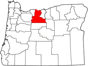 Wasco County map | |
| CDPs | ||
| Unincorporated communities | ||
| Ghost towns | ||
| Indian reservation | ||
| Footnotes | ‡This populated place also has portions in an adjacent county or counties | |
| ||
| People | |
|---|---|
| Locations | |
| Incidents | |
| Legal cases | |
| In media and culture | |
| |
| Authority control |
|---|