Apac
Apac is a town in Apac District, Northern Uganda. It is the 'chief town' of the district and the district headquarters are located there. The district is named after the town.
Apac | |
|---|---|
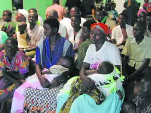 Patients at Apac Hospital | |
 Apac Location in Uganda | |
| Coordinates: 01°59′06″N 32°32′06″E | |
| Country | |
| Region | Northern Uganda |
| Sub-region | Lango sub-region |
| District | Apac District |
| Elevation | 3,350 ft (1,020 m) |
| Population (2014 Census) | |
| • Total | 14,503[1] |
Location
Apac is located approximately 118 kilometres (73 mi), by road, south of Gulu, the largest city in Northern Uganda.[2] This location lies approximately 62 kilometres (39 mi), by road, southwest of Lira, the largest city in the Lango sub-region.[3] The coordinates of the town are:1°59'06.0"N, 32°32'06.0"E (Latitude:1.9850; Longitude:32.5350).[4]
Population
The 2002 national census estimated the population of the town at about 10,140. In 2010, the population of Apac was estimated at about 13,300, by the Uganda Bureau of Statistics (UBOS). In 2011, UBOS estimated the mid-year population of Apac at approximately 13,700.[5] In August 2014, the national population census put the population of Apac at 14,503.[1]
Points of interest
The following points of interest lie in the town or near the town limits:
- The headquarters of Apac District Administration
- The offices of Apac Town Council
- Apac Hospital - A 120-bed public hospital, administered by the Uganda Ministry of Health
- Alenga Primary School - A public elementary school on the outskirts of town
- Apac Central Market
Notable people
- Milton Obote, former President and Prime Minister
Photos
See also
References
- UBOS, . (27 August 2014). "The Population of The Regions of the Republic of Uganda And All Cities And Towns of More Than 15,000 Inhabitants". Citypopulation.de Quoting Uganda Bureau of Statistics (UBOS). Retrieved 22 February 2015.CS1 maint: numeric names: authors list (link)
- Google (31 December 2020). "Road Distance Between Gulu, Uganda And Apac, Uganda" (Map). Google Maps. Google. Retrieved 31 December 2020.
- Google (31 December 2020). "Road Distance Between Apac And Lira In Uganda" (Map). Google Maps. Google. Retrieved 31 December 2020.
- Google (2 July 2015). "Location of Apac, Northern Region, Uganda" (Map). Google Maps. Google. Retrieved 2 July 2015.
- UBOS, . "Estimated Population of Apac In 2002, 2010 And 2011" (PDF). Uganda Bureau of Statistics (UBOS). Archived from the original (PDF) on 7 July 2014. Retrieved 2 June 2014.CS1 maint: numeric names: authors list (link)
External links
Capital: Apac | ||
| Towns and villages | 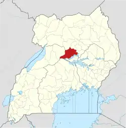 | |
| Geography | ||
| Transport | ||
| Economy | ||
| Notable landmarks |
| |
| Education |
| |
| Health | ||
| Notable people | ||