Arcanum, Ohio
Arcanum is a village in Darke County, Ohio, United States. The population was 2,129 at the 2010 census.
Arcanum, Ohio | |
|---|---|
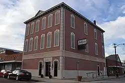 Arcanum Municipal Center | |
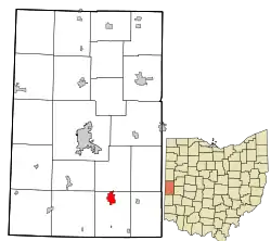 Location in Darke County and the state of Ohio | |
| Coordinates: 39°59′30″N 84°33′17″W | |
| Country | United States |
| State | Ohio |
| County | Darke |
| Government | |
| • Mayor | Gregory T. Baumle |
| Area | |
| • Total | 1.27 sq mi (3.29 km2) |
| • Land | 1.27 sq mi (3.29 km2) |
| • Water | 0.00 sq mi (0.00 km2) |
| Elevation | 1,050 ft (320 m) |
| Population | |
| • Total | 2,129 |
| • Estimate (2019)[4] | 2,008 |
| • Density | 1,578.62/sq mi (609.49/km2) |
| Time zone | UTC-5 (Eastern (EST)) |
| • Summer (DST) | UTC-4 (EDT) |
| ZIP code | 45304 |
| Area codes | 937, 326 |
| FIPS code | 39-02330[5] |
| GNIS feature ID | 1066324[2] |
| Website | http://villageofarcanum.com/ |
History
Arcanum was laid out in 1849.[6] The railroad arrived to Arcanum in 1852.[7] A post office has been in operation at Arcanum since 1852.[8]
Geography
Arcanum is located at 39°59′30″N 84°33′17″W (39.991714, -84.554797).[9]
According to the United States Census Bureau, the village has a total area of 1.30 square miles (3.37 km2), all land.[10]
Demographics
| Historical population | |||
|---|---|---|---|
| Census | Pop. | %± | |
| 1870 | 450 | — | |
| 1880 | 778 | 72.9% | |
| 1890 | 1,134 | 45.8% | |
| 1900 | 1,225 | 8.0% | |
| 1910 | 1,361 | 11.1% | |
| 1920 | 1,311 | −3.7% | |
| 1930 | 1,149 | −12.4% | |
| 1940 | 1,188 | 3.4% | |
| 1950 | 1,530 | 28.8% | |
| 1960 | 1,678 | 9.7% | |
| 1970 | 1,993 | 18.8% | |
| 1980 | 2,002 | 0.5% | |
| 1990 | 1,953 | −2.4% | |
| 2000 | 2,076 | 6.3% | |
| 2010 | 2,129 | 2.6% | |
| 2019 (est.) | 2,008 | [4] | −5.7% |
| U.S. Decennial Census[11] | |||
2010 census
As of the census[3] of 2010, there were 2,129 people, 888 households, and 608 families living in the village. The population density was 1,637.7 inhabitants per square mile (632.3/km2). There were 980 housing units at an average density of 753.8 per square mile (291.0/km2). The racial makeup of the village was 98.8% White, 0.1% African American, 0.2% Asian, 0.1% from other races, and 0.7% from two or more races. Hispanic or Latino of any race were 0.3% of the population.
There were 888 households, of which 35.8% had children under the age of 18 living with them, 53.5% were married couples living together, 11.5% had a female householder with no husband present, 3.5% had a male householder with no wife present, and 31.5% were non-families. 28.0% of all households were made up of individuals, and 13.2% had someone living alone who was 65 years of age or older. The average household size was 2.40, and the average family size was 2.94.
The median age in the village was 37.4 years. 26.5% of residents were under the age of 18; 7.4% were between the ages of 18 and 24; 26.7% were from 25 to 44; 22.6% were from 45 to 64, and 17.1% were 65 years of age or older. The gender makeup of the village was 47.3% male and 52.7% female.
2000 census
As of the census[5] of 2000, there were 2,076 people, 853 households, and 603 families living in the village. The population density was 1,789.8 people per square mile (691.0/km2). There were 891 housing units at an average density of 768.2 per square mile (296.6/km2). The racial makeup of the village was 98.75% White, 0.05% Native American, 0.19% Asian, and 1.01% from two or more races. Hispanic or Latino of any race were 0.39% of the population. There were 853 households, out of which 34.0% had children under the age of 18 living with them, 58.9% were married couples living together, 9.3% had a female householder with no husband present, and 29.3% were non-families. 25.9% of all households were made up of individuals, and 14.7% had someone living alone who was 65 years of age or older. The average household size was 2.43, and the average family size was 2.92.
In the village, the population was spread out, with 26.4% under the age of 18, 8.2% from 18 to 24, 28.1% from 25 to 44, 19.8% from 45 to 64, and 17.4% who were 65 years of age or older. The median age was 35 years. For every 100 females, there were 89.8 males. For every 100 females age 18 and over, there were 84.3 males.
The median income for a household in the village was $42,649, and the median income for a family was $51,429. Males had a median income of $36,850 versus $21,597 for females. The per capita income for the village was $19,597. About 2.5% of families and 3.5% of the population were below the poverty line, including 2.0% of those under age 18 and 5.9% of those age 65 or over.
Government
The Village of Arcanum functions as a Mayor and Council form of government, meaning that the mayor will cast a vote only in the case of a tie amongst the council. The Village Administrator oversees all of the operations of the Arcanum utilities, as well as anything about the water and sewer systems.[12]
Current elected officials of the village of Arcanum include:
- Mayor: Bonnie L Millard
- Council president: Bonnie Millard
- Council members: Tim Philpot, Rick Genovesi, Jerry Boolman, Blaine Vencill, Bonnie Millard, Eric VanHoose
Education
High School Men's basketball state champions 1969.
References
- "2019 U.S. Gazetteer Files". United States Census Bureau. Retrieved July 27, 2020.
- "US Board on Geographic Names". United States Geological Survey. 2007-10-25. Retrieved 2008-01-31.
- "U.S. Census website". United States Census Bureau. Retrieved 2013-01-06.
- "Population and Housing Unit Estimates". Retrieved May 21, 2020.
- "U.S. Census website". United States Census Bureau. Retrieved 2008-01-31.
- The History of Darke County, Ohio. W. H. Beers & Company. 1880. p. 461.
- Wilson, Frazer Ells (1914). History of Darke County, Ohio, from its earliest settlement to the present time, Vol. 1. Milford, Ohio: Hobart Publishing Company. p. 597.
- "Darke County". Jim Forte Postal History. Retrieved 25 December 2015.
- "US Gazetteer files: 2010, 2000, and 1990". United States Census Bureau. 2011-02-12. Retrieved 2011-04-23.
- "US Gazetteer files 2010". United States Census Bureau. Archived from the original on 2012-01-25. Retrieved 2013-01-06.
- "Census of Population and Housing". Census.gov. Retrieved June 4, 2015.
- Arcanum, Ohio Archived April 30, 2008, at the Wayback Machine
Municipalities and communities of Darke County, Ohio, United States | ||
|---|---|---|
| City |  Map of Ohio highlighting Darke County | |
| Villages | ||
| Townships | ||
| Unincorporated communities | ||
| Footnotes | ‡This populated place also has portions in an adjacent county or counties | |
| ||