Ariake Sea
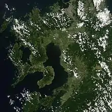
The Ariake Sea (有明海, Ariake-kai) is a body of salt water surrounded by Fukuoka, Saga, Nagasaki, and Kumamoto Prefectures, all of which lie on the island of Kyūshū in Japan. It is the largest bay in Kyūshū. Its deepest point is only about 50 meters (165 ft) deep, and extreme tides exceed 4 meters (13 ft), covering roughly 1,700 square kilometres (660 sq mi). Isahaya Bay is a branch of the Ariake Sea. Across the Amakusa Islands lies the Yatsushiro Sea.
Many harbors are located on the coast of the Ariake Sea. Among them are Misumi (in the city of Uki, Kumamoto Prefecture), Shimabara (Shimabara, Nagasaki), Taira (Unzen, Nagasaki), Nagasu (Nagasu, Kumamoto), Kumamoto (Kumamoto, Kumamoto), Miike (Omuta, Fukuoka), Kuchinotsu (Minamishimabara, Nagasaki), and Oniike (Amakusa, Kumamoto). Five ferry routes cross the Ariake Sea.
Various species of fauna, including mudskippers, pen shells (Atrina pectinata), and fiddler crabs, live in the Ariake Sea. In autumn, the Suaeda halophyte shichimenso (Suaeda japonica) grows along the shore.
The Ariake Sea is used for aquaculture, with nori being a major product. Recent years have brought increasing pollution, with resultant red tides. There is ongoing land reclamation, as evidenced by satellite imagery, despite government attempts to dissuade farmers from carrying out the activity.
Sources
- 有明海 (Japanese Wikipedia, including map)
External links
- 有明海総合研究プロジェクト "Ariake Sea General Research Project" (Saga University, in Japanese)
- 有明海等環境情報・研究ネットワーク "Environmental Information on Ariake Etc.: Research Network" (Japan Fisheries Resource Conservation Association, in Japanese)
| Authority control |
|---|
